- Includes realistic navigation features showing everything from shaded depth contours and coastlines to spot soundings, navaids, port plans, wrecks, obstructions, intertidal zones, restricted areas, IALA symbols and more.
- Features smooth displays, including seamless transitions between zoom levels and more continuity across chart boundaries.
- Allows users to choose between standard 2-D direct overhead or 3-D "over the bow" map perspective to make chart reading and orientation easier.
- Provides Safety Shading (in compatible units), allowing mariners to enable contour shading for all depth contours shallower than user-defined safe depths.
- Provides Fishing Charts (in compatible units), allowing mariners to scope out bottom contours and depth soundings with less visual clutter on the display.
- Allows users to conveniently plan and organize routes, from your computer, before your trip with HomePort™, compatible trip-planning software (sold separately).
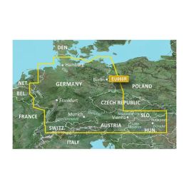
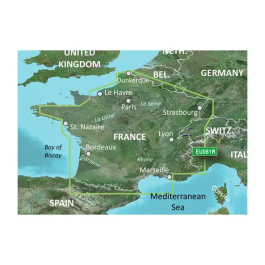
Coverage:
Detailed coverage of coastal and interior France including the coast from Marseille to St. Cyprien, Bayonne to St-Nazaire and La Havre to Dunkirk. Coverage of interior waterways include the Adour, Garonne, Charente, Loire, Seine and Rhone River systems. The Sevre-Nantaise, Somme, Meuse, Moselle, and Saone Rivers, the Rhine from Basel, CH to Karlsruhe, DE; Lake Leman (Geneva), Lake Neuchatel, Lake Biel, Lake Morat, the Canal du Midi, the Canal du Centre and the Rhine-Rhone Canal are also covered.