Garmin GPSMAP 742 (010-01738-01)
Garmin GPSMAP 742 (010-01738-01)
Model Number: 010-01738-01
Out of stock
 View full details
 WhatsApp
 SMS - Text us!
 Email Us!
 Help Desk
Tech Specs
Garmin GPSMAP 742 (010-01738-01) - Your Ultimate Navigation Companion
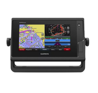
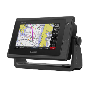
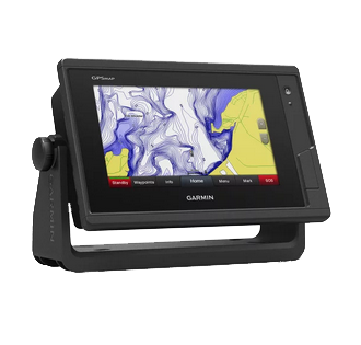
Experience unparalleled navigation on the water with the Garmin GPSMAP 742. This state-of-the-art chartplotter features a crystal-clear 7-inch touchscreen that enhances your boating experience. Merging advanced technology with user-friendly functionalities, the Garmin GPSMAP 742 is an indispensable tool for marine enthusiasts seeking precision and connectivity on the water.
Key Features
- Next-Generation Connectivity: Integrated Wi-Fi for access to the ActiveCaptain™ app, enabling remote management of marine experiences.
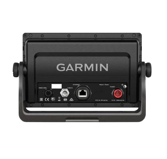
- Robust Networking Capabilities: Supports Garmin Marine Network and NMEA 2000 for connecting autopilots, weather sensors, and more.
- Fast Position Refresh Rate: 10 Hz GPS and GLONASS receiver refreshes position and heading 10 times per second, ensuring smooth navigation.
- Exceptional Cartography: Preloaded with LakeVü g3 and BlueChart® g3 maps for comprehensive coverage and detailed clarity.
- Personalized Mapping: Quickdraw Contours feature allows custom HD fishing maps with 1-foot contours.
- Sailing Features: Built-in SailAssist tools optimize sailing performance with enhanced wind data and pre-race guidance.
Data Insights
The Garmin GPSMAP 742 is designed for optimal performance, boasting a position refresh rate that enhances real-time navigation accuracy. With the ability to store up to 5,000 waypoints, it provides extensive mapping capabilities that are vital for both leisure and competitive sailing activities.
Usage Instructions
To get the most out of your Garmin GPSMAP 742, start by connecting it to power and mounting it securely. Use the touchscreen interface to access charts and features, and take advantage of the ActiveCaptain™ app for real-time updates and notifications. Customize your maps using Quickdraw Contours for tailored fishing experiences.
Design & Material
The design of the Garmin GPSMAP 742 is sleek and modern, built for durability and ease of use in marine environments. Its high-resolution display ensures visibility under various lighting conditions, making navigation simple and intuitive.
- Durable Construction: Designed to withstand harsh marine conditions.
- High-Resolution Display: 7-inch touchscreen offers exceptional clarity.
- Intuitive Interface: User-friendly layout simplifies navigation and feature access.
- Weather Resistant: Built to endure moisture and splashes.
- Compact Design: Space-saving structure ideal for any boat.
- Easy Mounting: Versatile installation options for convenience.
Final Verdict
Upgrade your boating experience with the Garmin GPSMAP 742 (010-01738-01). This advanced chartplotter not only enhances navigation but also facilitates a connected experience on the water. Don’t miss out on the opportunity to elevate your marine adventures—order your Garmin GPSMAP 742 today!
In The Box
- GPSMAP 742 chartplotter
- Power cable
- Bail mount kit with knobs
- Flush mount kit with gasket
- Protective cover
- Trim piece snap covers
- Documentation
Manual & Warranty
 Garmin Warranty
Do you have an old GPS unit lying around? The GPS Nation Trade In and Up program is a great way to trade in your old and used GPS for credit towards a new GPS. The choice is entirely yours! We’ve made the process simple and streamlined. Follow these simple steps, and you will be on your way to receiving credit towards your brand new GPS!
1. Get a quote
To get your free quote, provide your GPS type, manufacturer, model, and condition. Within 24 hours, you will receive a quote for the trade-in value of your current product. The GPS trade-in/trade-up form is at the bottom of this page.
2. Ship your product(s) for trade
After accepting our offer, pack your product(s) safely and ship them to us using the pre-paid shipping label provided to you. We will provide a confirmation email when your trade-in arrives at our warehouse. You have 30 days from the date you complete your on-line trade to ship the product to GPS Nation.
3. Make your purchase
Once we receive your product at our warehouse and we validate the stated condition, we will send you a confirmation email. If you elect to receive credit towards a new GPS at gpsnation.com, your store credit will be issued, and you are free to make your purchase.
Reviews
Ask a Question
Tech Specs
Garmin GPSMAP 742 (010-01738-01) - Your Ultimate Navigation Companion
Experience unparalleled navigation on the water with the Garmin GPSMAP 742. This state-of-the-art chartplotter features a crystal-clear 7-inch touchscreen that enhances your boating experience. Merging advanced technology with user-friendly functionalities, the Garmin GPSMAP 742 is an indispensable tool for marine enthusiasts seeking precision and connectivity on the water.
Key Features
- Next-Generation Connectivity: Integrated Wi-Fi for access to the ActiveCaptain™ app, enabling remote management of marine experiences.
- Robust Networking Capabilities: Supports Garmin Marine Network and NMEA 2000 for connecting autopilots, weather sensors, and more.
- Fast Position Refresh Rate: 10 Hz GPS and GLONASS receiver refreshes position and heading 10 times per second, ensuring smooth navigation.
- Exceptional Cartography: Preloaded with LakeVü g3 and BlueChart® g3 maps for comprehensive coverage and detailed clarity.
- Personalized Mapping: Quickdraw Contours feature allows custom HD fishing maps with 1-foot contours.
- Sailing Features: Built-in SailAssist tools optimize sailing performance with enhanced wind data and pre-race guidance.
Data Insights
The Garmin GPSMAP 742 is designed for optimal performance, boasting a position refresh rate that enhances real-time navigation accuracy. With the ability to store up to 5,000 waypoints, it provides extensive mapping capabilities that are vital for both leisure and competitive sailing activities.
Usage Instructions
To get the most out of your Garmin GPSMAP 742, start by connecting it to power and mounting it securely. Use the touchscreen interface to access charts and features, and take advantage of the ActiveCaptain™ app for real-time updates and notifications. Customize your maps using Quickdraw Contours for tailored fishing experiences.
Design & Material
The design of the Garmin GPSMAP 742 is sleek and modern, built for durability and ease of use in marine environments. Its high-resolution display ensures visibility under various lighting conditions, making navigation simple and intuitive.
- Durable Construction: Designed to withstand harsh marine conditions.
- High-Resolution Display: 7-inch touchscreen offers exceptional clarity.
- Intuitive Interface: User-friendly layout simplifies navigation and feature access.
- Weather Resistant: Built to endure moisture and splashes.
- Compact Design: Space-saving structure ideal for any boat.
- Easy Mounting: Versatile installation options for convenience.
Final Verdict
Upgrade your boating experience with the Garmin GPSMAP 742 (010-01738-01). This advanced chartplotter not only enhances navigation but also facilitates a connected experience on the water. Don’t miss out on the opportunity to elevate your marine adventures—order your Garmin GPSMAP 742 today!
In The Box
- GPSMAP 742 chartplotter
- Power cable
- Bail mount kit with knobs
- Flush mount kit with gasket
- Protective cover
- Trim piece snap covers
- Documentation
Manual & Warranty
Trade-In
Do you have an old GPS unit lying around? The GPS Nation Trade In and Up program is a great way to trade in your old and used GPS for credit towards a new GPS. The choice is entirely yours! We’ve made the process simple and streamlined. Follow these simple steps, and you will be on your way to receiving credit towards your brand new GPS!
1. Get a quote
To get your free quote, provide your GPS type, manufacturer, model, and condition. Within 24 hours, you will receive a quote for the trade-in value of your current product. The GPS trade-in/trade-up form is at the bottom of this page.
2. Ship your product(s) for trade
After accepting our offer, pack your product(s) safely and ship them to us using the pre-paid shipping label provided to you. We will provide a confirmation email when your trade-in arrives at our warehouse. You have 30 days from the date you complete your on-line trade to ship the product to GPS Nation.
3. Make your purchase
Once we receive your product at our warehouse and we validate the stated condition, we will send you a confirmation email. If you elect to receive credit towards a new GPS at gpsnation.com, your store credit will be issued, and you are free to make your purchase.
Overview
Garmin GPSMAP 742 (010-01738-01) - Your Ultimate Navigation Companion
Experience unparalleled navigation on the water with the Garmin GPSMAP 742. This state-of-the-art chartplotter features a crystal-clear 7-inch touchscreen that enhances your boating experience. Merging advanced technology with user-friendly functionalities, the Garmin GPSMAP 742 is an indispensable tool for marine enthusiasts seeking precision and connectivity on the water.
Key Features
- Next-Generation Connectivity: Integrated Wi-Fi for access to the ActiveCaptain™ app, enabling remote management of marine experiences.
- Robust Networking Capabilities: Supports Garmin Marine Network and NMEA 2000 for connecting autopilots, weather sensors, and more.
- Fast Position Refresh Rate: 10 Hz GPS and GLONASS receiver refreshes position and heading 10 times per second, ensuring smooth navigation.
- Exceptional Cartography: Preloaded with LakeVü g3 and BlueChart® g3 maps for comprehensive coverage and detailed clarity.
- Personalized Mapping: Quickdraw Contours feature allows custom HD fishing maps with 1-foot contours.
- Sailing Features: Built-in SailAssist tools optimize sailing performance with enhanced wind data and pre-race guidance.
Data Insights
The Garmin GPSMAP 742 is designed for optimal performance, boasting a position refresh rate that enhances real-time navigation accuracy. With the ability to store up to 5,000 waypoints, it provides extensive mapping capabilities that are vital for both leisure and competitive sailing activities.
Usage Instructions
To get the most out of your Garmin GPSMAP 742, start by connecting it to power and mounting it securely. Use the touchscreen interface to access charts and features, and take advantage of the ActiveCaptain™ app for real-time updates and notifications. Customize your maps using Quickdraw Contours for tailored fishing experiences.
Design & Material
The design of the Garmin GPSMAP 742 is sleek and modern, built for durability and ease of use in marine environments. Its high-resolution display ensures visibility under various lighting conditions, making navigation simple and intuitive.
- Durable Construction: Designed to withstand harsh marine conditions.
- High-Resolution Display: 7-inch touchscreen offers exceptional clarity.
- Intuitive Interface: User-friendly layout simplifies navigation and feature access.
- Weather Resistant: Built to endure moisture and splashes.
- Compact Design: Space-saving structure ideal for any boat.
- Easy Mounting: Versatile installation options for convenience.
Final Verdict
Upgrade your boating experience with the Garmin GPSMAP 742 (010-01738-01). This advanced chartplotter not only enhances navigation but also facilitates a connected experience on the water. Don’t miss out on the opportunity to elevate your marine adventures—order your Garmin GPSMAP 742 today!