

Garmin Worldwide Coastal Charts BlueChart g3 HXWW001G microSD/SD (010-C1137-20)
Garmin Worldwide Coastal Charts BlueChart g3 HXWW001G microSD/SD (010-C1137-20)
SKU: 010-C1137-20
Bajas existencias
 Ver todos los detalles
 WhatsApp
 SMS - Text us!
 Email Us!
 Help Desk
Reseñas
Especificaciones
Garmin Worldwide Coastal Charts BlueChart g3 HXWW001G microSD/SD (010-C1137-20)
Introduction
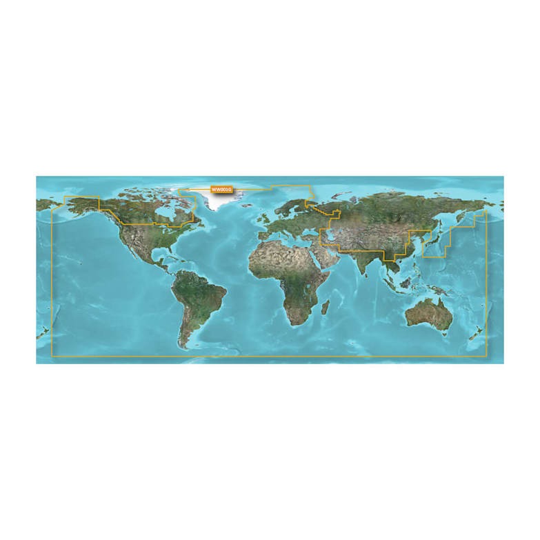
The Garmin BlueChart g3 HXWW001G Worldwide Coastal Charts microSD/SD card is designed to provide mariners with extensive global coastal mapping and navigation data. Built for use with compatible Garmin chartplotters, this chart package combines information from official hydrographic sources and trusted private data providers to create detailed and reliable marine charts.
Whether cruising coastal waters, navigating unfamiliar harbors, or planning offshore routes, BlueChart g3 delivers valuable navigational information including depth contours, spot soundings, navigational aids, tides, currents, marinas, and harbor details. Advanced chart features help improve situational awareness and support safer navigation in a wide range of marine environments.
With worldwide coastal coverage and enhanced chart presentation, the HXWW001G card offers an excellent solution for boaters seeking dependable navigation information across global waterways.
Key Features
Worldwide Coastal Coverage
- Provides extensive global coastal chart coverage.
- Supports navigation across a wide range of marine regions.
- Ideal for recreational and professional mariners.
- Helps simplify route planning and voyage preparation.
Detailed Marine Cartography
- Derived from official chart sources and trusted private data.
- Displays navigational aids and marine landmarks.
- Includes detailed harbor and marina information.
- Supports confident navigation in coastal waters.
Spot Soundings and Depth Contours
- Displays detailed underwater depth information.
- Helps identify channels, shoals, and underwater hazards.
- Improves route planning and situational awareness.
- Supports safer operation in changing water depths.
Tides and Currents Information
- Includes tidal and current data where available.
- Assists with navigation and trip planning.
- Helps mariners account for changing water conditions.
- Supports more informed decision-making on the water.
Shallow Water Shading
- User-defined depth shading feature.
- Highlights shallow areas for easier identification.
- Enhances awareness of potential navigation hazards.
- Simplifies operation in coastal and nearshore environments.
Advanced Chart Detail
- Detailed chart presentation for improved readability.
- Assists with port approaches and harbor navigation.
- Supports safer maneuvering in confined waterways.
- Enhances overall navigation confidence.
Navigation Insights
BlueChart® g3 charts provide a detailed view of the marine environment, helping mariners better understand surrounding waters and potential hazards. The inclusion of depth contours, spot soundings, tides, and currents allows users to make more informed navigational decisions while improving route efficiency.
The shallow water shading feature is particularly valuable for boaters operating in unfamiliar areas, as it visually highlights selected depth ranges to improve awareness of shallow zones. Combined with detailed harbor and marina information, the charts help streamline navigation from open water to port entry.
Whether planning long coastal passages or local boating trips, BlueChart g3 offers the chart detail needed to navigate with greater confidence.
Usage Instructions
Insert the BlueChart® g3 HXWW001G microSD/SD card into a compatible Garmin chartplotter according to the device's instructions. Once installed, access chart settings through the chartplotter menu to customize display preferences such as depth shading and chart overlays.
Use the included chart information for route planning, harbor approaches, navigation monitoring, and identifying underwater features. Regularly verify navigation information and follow safe boating practices when operating in marine environments.
Design & Compatibility
The Garmin BlueChart® g3 HXWW001G is supplied on a microSD/SD memory card for convenient installation and use with compatible Garmin marine electronics. The digital chart package is designed to integrate seamlessly with supported chartplotters, providing quick access to advanced marine mapping features.
Design Highlights
- Worldwide coastal chart coverage
- BlueChart® g3 marine mapping
- microSD/SD card format
- Compatible with supported Garmin chartplotters
- Official chart source integration
- Trusted private-source chart data
- Detailed harbor information
- Marina location details
- Navigational aid information
- Spot soundings and depth contours
- Tides and currents data
- User-defined shallow water shading
- Enhanced coastal navigation support
- Advanced chart detail presentation
- Improved route planning capabilities
- Designed for recreational and professional boating
Final Verdict
The Garmin BlueChart® g3 HXWW001G Worldwide Coastal Charts microSD/SD card is an excellent navigation solution for boaters who require reliable global coastal mapping. With detailed chart data, harbor information, depth contours, tidal information, and customizable shallow water shading, it provides the tools needed for confident marine navigation.
Whether you're cruising local coastlines, exploring new waterways, or planning extended voyages, BlueChart® g3 delivers comprehensive chart coverage and advanced navigation features that help make every journey safer and more efficient.
En la caja
Manual y garantía
¿Tiene una unidad GPS vieja por ahí? El programa Trade In and Up de GPS Nation es una excelente manera de canjear su GPS viejo y usado por crédito para un nuevo GPS. ¡La decisión es completamente suya! Hemos simplificado y optimizado el proceso. Siga estos sencillos pasos y estará en camino de recibir crédito para su nuevo GPS.
1. Obtenga una cotización
Para obtener una cotización gratuita, proporcione el tipo, el fabricante, el modelo y el estado de su GPS. En un plazo de 24 horas, recibirá una cotización por el valor de intercambio de su producto actual. El formulario de intercambio de GPS se encuentra en la parte inferior de esta página.
2. Envíe su(s) producto(s) para comercializarlos
Después de aceptar nuestra oferta, empaquete sus productos de forma segura y envíenoslos utilizando la etiqueta de envío prepaga que le proporcionamos. Le enviaremos un correo electrónico de confirmación cuando su canje llegue a nuestro almacén. Tiene 30 días a partir de la fecha en que complete su canje en línea para enviar el producto a GPS Nation.
3. Realiza tu compra
Una vez que recibamos su producto en nuestro almacén y validemos la condición indicada, le enviaremos un correo electrónico de confirmación. Si elige recibir crédito para un nuevo GPS en gpsnation.com, se emitirá su crédito de la tienda y podrá realizar su compra.
Reseñas
Haz una pregunta
Especificaciones
Garmin Worldwide Coastal Charts BlueChart g3 HXWW001G microSD/SD (010-C1137-20)
Introduction
The Garmin BlueChart g3 HXWW001G Worldwide Coastal Charts microSD/SD card is designed to provide mariners with extensive global coastal mapping and navigation data. Built for use with compatible Garmin chartplotters, this chart package combines information from official hydrographic sources and trusted private data providers to create detailed and reliable marine charts.
Whether cruising coastal waters, navigating unfamiliar harbors, or planning offshore routes, BlueChart g3 delivers valuable navigational information including depth contours, spot soundings, navigational aids, tides, currents, marinas, and harbor details. Advanced chart features help improve situational awareness and support safer navigation in a wide range of marine environments.
With worldwide coastal coverage and enhanced chart presentation, the HXWW001G card offers an excellent solution for boaters seeking dependable navigation information across global waterways.
Key Features
Worldwide Coastal Coverage
- Provides extensive global coastal chart coverage.
- Supports navigation across a wide range of marine regions.
- Ideal for recreational and professional mariners.
- Helps simplify route planning and voyage preparation.
Detailed Marine Cartography
- Derived from official chart sources and trusted private data.
- Displays navigational aids and marine landmarks.
- Includes detailed harbor and marina information.
- Supports confident navigation in coastal waters.
Spot Soundings and Depth Contours
- Displays detailed underwater depth information.
- Helps identify channels, shoals, and underwater hazards.
- Improves route planning and situational awareness.
- Supports safer operation in changing water depths.
Tides and Currents Information
- Includes tidal and current data where available.
- Assists with navigation and trip planning.
- Helps mariners account for changing water conditions.
- Supports more informed decision-making on the water.
Shallow Water Shading
- User-defined depth shading feature.
- Highlights shallow areas for easier identification.
- Enhances awareness of potential navigation hazards.
- Simplifies operation in coastal and nearshore environments.
Advanced Chart Detail
- Detailed chart presentation for improved readability.
- Assists with port approaches and harbor navigation.
- Supports safer maneuvering in confined waterways.
- Enhances overall navigation confidence.
Navigation Insights
BlueChart® g3 charts provide a detailed view of the marine environment, helping mariners better understand surrounding waters and potential hazards. The inclusion of depth contours, spot soundings, tides, and currents allows users to make more informed navigational decisions while improving route efficiency.
The shallow water shading feature is particularly valuable for boaters operating in unfamiliar areas, as it visually highlights selected depth ranges to improve awareness of shallow zones. Combined with detailed harbor and marina information, the charts help streamline navigation from open water to port entry.
Whether planning long coastal passages or local boating trips, BlueChart g3 offers the chart detail needed to navigate with greater confidence.
Usage Instructions
Insert the BlueChart® g3 HXWW001G microSD/SD card into a compatible Garmin chartplotter according to the device's instructions. Once installed, access chart settings through the chartplotter menu to customize display preferences such as depth shading and chart overlays.
Use the included chart information for route planning, harbor approaches, navigation monitoring, and identifying underwater features. Regularly verify navigation information and follow safe boating practices when operating in marine environments.
Design & Compatibility
The Garmin BlueChart® g3 HXWW001G is supplied on a microSD/SD memory card for convenient installation and use with compatible Garmin marine electronics. The digital chart package is designed to integrate seamlessly with supported chartplotters, providing quick access to advanced marine mapping features.
Design Highlights
- Worldwide coastal chart coverage
- BlueChart® g3 marine mapping
- microSD/SD card format
- Compatible with supported Garmin chartplotters
- Official chart source integration
- Trusted private-source chart data
- Detailed harbor information
- Marina location details
- Navigational aid information
- Spot soundings and depth contours
- Tides and currents data
- User-defined shallow water shading
- Enhanced coastal navigation support
- Advanced chart detail presentation
- Improved route planning capabilities
- Designed for recreational and professional boating
Final Verdict
The Garmin BlueChart® g3 HXWW001G Worldwide Coastal Charts microSD/SD card is an excellent navigation solution for boaters who require reliable global coastal mapping. With detailed chart data, harbor information, depth contours, tidal information, and customizable shallow water shading, it provides the tools needed for confident marine navigation.
Whether you're cruising local coastlines, exploring new waterways, or planning extended voyages, BlueChart® g3 delivers comprehensive chart coverage and advanced navigation features that help make every journey safer and more efficient.
En la caja
Manual y garantía
Programa de canje
¿Tiene una unidad GPS vieja por ahí? El programa Trade In and Up de GPS Nation es una excelente manera de canjear su GPS viejo y usado por crédito para un nuevo GPS. ¡La decisión es completamente suya! Hemos simplificado y optimizado el proceso. Siga estos sencillos pasos y estará en camino de recibir crédito para su nuevo GPS.
1. Obtenga una cotización
Para obtener una cotización gratuita, proporcione el tipo, el fabricante, el modelo y el estado de su GPS. En un plazo de 24 horas, recibirá una cotización por el valor de intercambio de su producto actual. El formulario de intercambio de GPS se encuentra en la parte inferior de esta página.
2. Envíe su(s) producto(s) para comercializarlos
Después de aceptar nuestra oferta, empaquete sus productos de forma segura y envíenoslos utilizando la etiqueta de envío prepaga que le proporcionamos. Le enviaremos un correo electrónico de confirmación cuando su canje llegue a nuestro almacén. Tiene 30 días a partir de la fecha en que complete su canje en línea para enviar el producto a GPS Nation.
3. Realiza tu compra
Una vez que recibamos su producto en nuestro almacén y validemos la condición indicada, le enviaremos un correo electrónico de confirmación. Si elige recibir crédito para un nuevo GPS en gpsnation.com, se emitirá su crédito de la tienda y podrá realizar su compra.
Descripción general
Garmin Worldwide Coastal Charts BlueChart g3 HXWW001G microSD/SD (010-C1137-20)
Introduction
The Garmin BlueChart g3 HXWW001G Worldwide Coastal Charts microSD/SD card is designed to provide mariners with extensive global coastal mapping and navigation data. Built for use with compatible Garmin chartplotters, this chart package combines information from official hydrographic sources and trusted private data providers to create detailed and reliable marine charts.
Whether cruising coastal waters, navigating unfamiliar harbors, or planning offshore routes, BlueChart g3 delivers valuable navigational information including depth contours, spot soundings, navigational aids, tides, currents, marinas, and harbor details. Advanced chart features help improve situational awareness and support safer navigation in a wide range of marine environments.
With worldwide coastal coverage and enhanced chart presentation, the HXWW001G card offers an excellent solution for boaters seeking dependable navigation information across global waterways.
Key Features
Worldwide Coastal Coverage
- Provides extensive global coastal chart coverage.
- Supports navigation across a wide range of marine regions.
- Ideal for recreational and professional mariners.
- Helps simplify route planning and voyage preparation.
Detailed Marine Cartography
- Derived from official chart sources and trusted private data.
- Displays navigational aids and marine landmarks.
- Includes detailed harbor and marina information.
- Supports confident navigation in coastal waters.
Spot Soundings and Depth Contours
- Displays detailed underwater depth information.
- Helps identify channels, shoals, and underwater hazards.
- Improves route planning and situational awareness.
- Supports safer operation in changing water depths.
Tides and Currents Information
- Includes tidal and current data where available.
- Assists with navigation and trip planning.
- Helps mariners account for changing water conditions.
- Supports more informed decision-making on the water.
Shallow Water Shading
- User-defined depth shading feature.
- Highlights shallow areas for easier identification.
- Enhances awareness of potential navigation hazards.
- Simplifies operation in coastal and nearshore environments.
Advanced Chart Detail
- Detailed chart presentation for improved readability.
- Assists with port approaches and harbor navigation.
- Supports safer maneuvering in confined waterways.
- Enhances overall navigation confidence.
Navigation Insights
BlueChart® g3 charts provide a detailed view of the marine environment, helping mariners better understand surrounding waters and potential hazards. The inclusion of depth contours, spot soundings, tides, and currents allows users to make more informed navigational decisions while improving route efficiency.
The shallow water shading feature is particularly valuable for boaters operating in unfamiliar areas, as it visually highlights selected depth ranges to improve awareness of shallow zones. Combined with detailed harbor and marina information, the charts help streamline navigation from open water to port entry.
Whether planning long coastal passages or local boating trips, BlueChart g3 offers the chart detail needed to navigate with greater confidence.
Usage Instructions
Insert the BlueChart® g3 HXWW001G microSD/SD card into a compatible Garmin chartplotter according to the device's instructions. Once installed, access chart settings through the chartplotter menu to customize display preferences such as depth shading and chart overlays.
Use the included chart information for route planning, harbor approaches, navigation monitoring, and identifying underwater features. Regularly verify navigation information and follow safe boating practices when operating in marine environments.
Design & Compatibility
The Garmin BlueChart® g3 HXWW001G is supplied on a microSD/SD memory card for convenient installation and use with compatible Garmin marine electronics. The digital chart package is designed to integrate seamlessly with supported chartplotters, providing quick access to advanced marine mapping features.
Design Highlights
- Worldwide coastal chart coverage
- BlueChart® g3 marine mapping
- microSD/SD card format
- Compatible with supported Garmin chartplotters
- Official chart source integration
- Trusted private-source chart data
- Detailed harbor information
- Marina location details
- Navigational aid information
- Spot soundings and depth contours
- Tides and currents data
- User-defined shallow water shading
- Enhanced coastal navigation support
- Advanced chart detail presentation
- Improved route planning capabilities
- Designed for recreational and professional boating
Final Verdict
The Garmin BlueChart® g3 HXWW001G Worldwide Coastal Charts microSD/SD card is an excellent navigation solution for boaters who require reliable global coastal mapping. With detailed chart data, harbor information, depth contours, tidal information, and customizable shallow water shading, it provides the tools needed for confident marine navigation.
Whether you're cruising local coastlines, exploring new waterways, or planning extended voyages, BlueChart® g3 delivers comprehensive chart coverage and advanced navigation features that help make every journey safer and more efficient.


