

Garmin GPSMAP 1243xsv US+Canada GN+ w/18HD+ (010-02367-80)
Garmin GPSMAP 1243xsv US+Canada GN+ w/18HD+ (010-02367-80)
SKU: 010-02367-80
En rupture de stock
 WhatsApp
 SMS - Text us!
 Email Us!
 Help Desk
Avis
Spécifications
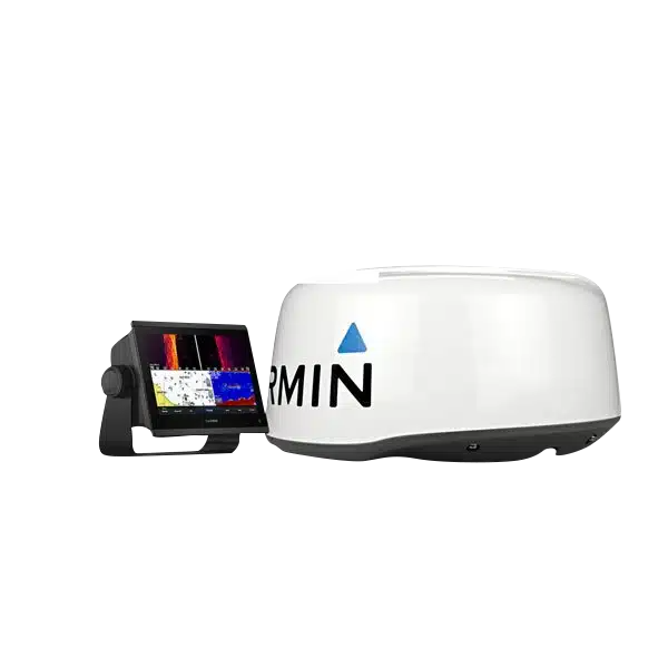
Garmin GPSMAP 1243xsv US+Canada Marine Chartplotter with 18HD+ Radar Integration
Introduction
The Garmin GPSMAP 1243xsv is a 12-inch chartplotter and fishfinder system engineered for serious anglers and commercial operators who demand real-time sonar performance and precision navigation. This integrated unit combines advanced scanning sonar, GNSS positioning, and marine-grade connectivity into a single touchscreen display, eliminating the need for multiple standalone devices while delivering consistent depth tracking, fish detection, and waypoint navigation across US and Canadian waters.
Key Features
- 12-inch IPS touchscreen display with edge-to-edge glass and sunlight-readable visibility in direct sunlight conditions
- Ultra High-Definition SideVü™ and ClearVü™ scanning sonar for 270-degree horizontal and vertical fish and structure detection
- 1 kW CHIRP traditional sonar with exceptional target separation and depth capabilities to 5,000 feet
- 10 Hz GNSS receiver supporting GPS, GLONASS, and Galileo satellite systems for multi-constellation positioning
- Real-time software updates and smart notifications via integrated Wi-Fi and ActiveCaptain® app connectivity
- Dual NMEA 2000® and NMEA 0183 connections for networking with marine electronics and compatible radar systems including GMR 18HD+ integration
Data Insights
The 10 Hz GNSS update rate on the GPSMAP 1243xsv delivers positioning accuracy within 9 feet across most operating conditions, significantly improving waypoint precision and route tracking compared to standard 1 Hz GPS receivers. The 1 kW CHIRP sonar transmitter produces real-time target separation that distinguishes individual fish from structure at depths up to 5,000 feet, while the dual-frequency scanning sonar provides simultaneous side and forward viewing capability for comprehensive water column analysis during both shallow and deep-water operations.
Usage Instructions
Install the unit in a secure, protected mounting location with clear visibility of the touchscreen. Connect NMEA 2000® and power connections according to manufacturer specifications, then configure your navigation maps and sonar frequency settings through the on-screen menu system. Enable ActiveCaptain® Wi-Fi connectivity to receive automatic software updates, weather alerts, and real-time data overlays. Regularly update your chart data to ensure accurate coastal and inland waterway information for your region.
Design & Material
The GPSMAP 1243xsv features a marine-grade construction designed to operate reliably in saltwater, freshwater, and varying climate conditions. The compact form factor accommodates aftermarket or factory dashboard installations without requiring major structural modifications, while the integrated antenna and sealed electronics protect against salt spray, vibration, and moisture exposure inherent in marine environments.
- Corrosion-resistant housing with black and white exterior finish rated for extended saltwater exposure
- Reinforced touchscreen panel with responsive input sensitivity and anti-glare treatment for extended daylight visibility
- Integrated single-cable sonar transducer connection reducing installation complexity and deck clutter
- Compact profile measuring approximately 15 inches wide and 12 inches deep for streamlined dashboard integration
- Weather-sealed connectors for NMEA 2000®, NMEA 0183, and auxiliary sensor inputs preventing corrosion and water intrusion
- Factory-installed US and Canada chart data covering coastal waters, the Great Lakes, and major river systems with regular update availability
Final Verdict
The Garmin GPSMAP 1243xsv delivers professional-grade chartplotting and sonar performance in a single integrated display unit, eliminating compatibility concerns and reducing overall system cost compared to separate GPS and fishfinder purchases. The combination of 10 Hz precision navigation, real-time sonar imaging, and seamless connectivity to advanced radar systems makes this unit essential for anyone navigating and fishing US and Canadian waters where accuracy and reliability directly impact success. Upgrade your marine electronics package now and gain the situational awareness that separates occasional boaters from consistent performers on the water.
Dans la boîte
microSD preinstalled
Power cable
NMEA 2000 T-connector
NMEA 2000 drop cable
Bail mount with knobs
Flush mount kit with gasket
Protective cover
Trim piece snap covers
Documentation
GPSMAP x3 chartplotters are preloaded with Garmin Navionics+ offshore, coastal, and inland water charts for the U.S. and Canada
Vous avez un vieux GPS qui traîne ? Le programme Trade In and Up de GPS Nation est un excellent moyen d'échanger votre ancien GPS usagé contre un crédit pour l'achat d'un nouveau GPS. Le choix vous appartient entièrement ! Nous avons simplifié et rationalisé le processus. Suivez ces étapes simples et vous serez sur la bonne voie pour recevoir un crédit pour votre tout nouveau GPS !
1. Obtenez un devis
Pour obtenir votre devis gratuit, indiquez le type, le fabricant, le modèle et l'état de votre GPS. Dans les 24 heures, vous recevrez un devis correspondant à la valeur de reprise de votre produit actuel. Le formulaire de reprise/d'échange de GPS se trouve au bas de cette page.
2. Expédiez votre/vos produit(s) pour le commerce
Après avoir accepté notre offre, emballez votre ou vos produits en toute sécurité et expédiez-les-nous à l'aide de l'étiquette d'expédition prépayée qui vous a été fournie. Nous vous enverrons un e-mail de confirmation lorsque votre échange arrivera à notre entrepôt. Vous disposez de 30 jours à compter de la date à laquelle vous avez terminé votre échange en ligne pour expédier le produit à GPS Nation.
3. Effectuez votre achat
Une fois que nous aurons reçu votre produit à notre entrepôt et que nous aurons validé l'état indiqué, nous vous enverrons un e-mail de confirmation. Si vous choisissez de recevoir un crédit pour un nouveau GPS sur gpsnation.com, votre crédit de magasin sera émis et vous serez libre de procéder à votre achat.
Manuel et garantie
 Garmin Warranty
Avis
Poser une question
Spécifications
Garmin GPSMAP 1243xsv US+Canada Marine Chartplotter with 18HD+ Radar Integration
Introduction
The Garmin GPSMAP 1243xsv is a 12-inch chartplotter and fishfinder system engineered for serious anglers and commercial operators who demand real-time sonar performance and precision navigation. This integrated unit combines advanced scanning sonar, GNSS positioning, and marine-grade connectivity into a single touchscreen display, eliminating the need for multiple standalone devices while delivering consistent depth tracking, fish detection, and waypoint navigation across US and Canadian waters.
Key Features
- 12-inch IPS touchscreen display with edge-to-edge glass and sunlight-readable visibility in direct sunlight conditions
- Ultra High-Definition SideVü™ and ClearVü™ scanning sonar for 270-degree horizontal and vertical fish and structure detection
- 1 kW CHIRP traditional sonar with exceptional target separation and depth capabilities to 5,000 feet
- 10 Hz GNSS receiver supporting GPS, GLONASS, and Galileo satellite systems for multi-constellation positioning
- Real-time software updates and smart notifications via integrated Wi-Fi and ActiveCaptain® app connectivity
- Dual NMEA 2000® and NMEA 0183 connections for networking with marine electronics and compatible radar systems including GMR 18HD+ integration
Data Insights
The 10 Hz GNSS update rate on the GPSMAP 1243xsv delivers positioning accuracy within 9 feet across most operating conditions, significantly improving waypoint precision and route tracking compared to standard 1 Hz GPS receivers. The 1 kW CHIRP sonar transmitter produces real-time target separation that distinguishes individual fish from structure at depths up to 5,000 feet, while the dual-frequency scanning sonar provides simultaneous side and forward viewing capability for comprehensive water column analysis during both shallow and deep-water operations.
Usage Instructions
Install the unit in a secure, protected mounting location with clear visibility of the touchscreen. Connect NMEA 2000® and power connections according to manufacturer specifications, then configure your navigation maps and sonar frequency settings through the on-screen menu system. Enable ActiveCaptain® Wi-Fi connectivity to receive automatic software updates, weather alerts, and real-time data overlays. Regularly update your chart data to ensure accurate coastal and inland waterway information for your region.
Design & Material
The GPSMAP 1243xsv features a marine-grade construction designed to operate reliably in saltwater, freshwater, and varying climate conditions. The compact form factor accommodates aftermarket or factory dashboard installations without requiring major structural modifications, while the integrated antenna and sealed electronics protect against salt spray, vibration, and moisture exposure inherent in marine environments.
- Corrosion-resistant housing with black and white exterior finish rated for extended saltwater exposure
- Reinforced touchscreen panel with responsive input sensitivity and anti-glare treatment for extended daylight visibility
- Integrated single-cable sonar transducer connection reducing installation complexity and deck clutter
- Compact profile measuring approximately 15 inches wide and 12 inches deep for streamlined dashboard integration
- Weather-sealed connectors for NMEA 2000®, NMEA 0183, and auxiliary sensor inputs preventing corrosion and water intrusion
- Factory-installed US and Canada chart data covering coastal waters, the Great Lakes, and major river systems with regular update availability
Final Verdict
The Garmin GPSMAP 1243xsv delivers professional-grade chartplotting and sonar performance in a single integrated display unit, eliminating compatibility concerns and reducing overall system cost compared to separate GPS and fishfinder purchases. The combination of 10 Hz precision navigation, real-time sonar imaging, and seamless connectivity to advanced radar systems makes this unit essential for anyone navigating and fishing US and Canadian waters where accuracy and reliability directly impact success. Upgrade your marine electronics package now and gain the situational awareness that separates occasional boaters from consistent performers on the water.
Dans la boîte
microSD preinstalled
Power cable
NMEA 2000 T-connector
NMEA 2000 drop cable
Bail mount with knobs
Flush mount kit with gasket
Protective cover
Trim piece snap covers
Documentation
GPSMAP x3 chartplotters are preloaded with Garmin Navionics+ offshore, coastal, and inland water charts for the U.S. and Canada
Programme d'échange
Vous avez un vieux GPS qui traîne ? Le programme Trade In and Up de GPS Nation est un excellent moyen d'échanger votre ancien GPS usagé contre un crédit pour l'achat d'un nouveau GPS. Le choix vous appartient entièrement ! Nous avons simplifié et rationalisé le processus. Suivez ces étapes simples et vous serez sur la bonne voie pour recevoir un crédit pour votre tout nouveau GPS !
1. Obtenez un devis
Pour obtenir votre devis gratuit, indiquez le type, le fabricant, le modèle et l'état de votre GPS. Dans les 24 heures, vous recevrez un devis correspondant à la valeur de reprise de votre produit actuel. Le formulaire de reprise/d'échange de GPS se trouve au bas de cette page.
2. Expédiez votre/vos produit(s) pour le commerce
Après avoir accepté notre offre, emballez votre ou vos produits en toute sécurité et expédiez-les-nous à l'aide de l'étiquette d'expédition prépayée qui vous a été fournie. Nous vous enverrons un e-mail de confirmation lorsque votre échange arrivera à notre entrepôt. Vous disposez de 30 jours à compter de la date à laquelle vous avez terminé votre échange en ligne pour expédier le produit à GPS Nation.
3. Effectuez votre achat
Une fois que nous aurons reçu votre produit à notre entrepôt et que nous aurons validé l'état indiqué, nous vous enverrons un e-mail de confirmation. Si vous choisissez de recevoir un crédit pour un nouveau GPS sur gpsnation.com, votre crédit de magasin sera émis et vous serez libre de procéder à votre achat.
Manuel et garantie
Aperçu
Garmin GPSMAP 1243xsv US+Canada Marine Chartplotter with 18HD+ Radar Integration
Introduction
The Garmin GPSMAP 1243xsv is a 12-inch chartplotter and fishfinder system engineered for serious anglers and commercial operators who demand real-time sonar performance and precision navigation. This integrated unit combines advanced scanning sonar, GNSS positioning, and marine-grade connectivity into a single touchscreen display, eliminating the need for multiple standalone devices while delivering consistent depth tracking, fish detection, and waypoint navigation across US and Canadian waters.
Key Features
- 12-inch IPS touchscreen display with edge-to-edge glass and sunlight-readable visibility in direct sunlight conditions
- Ultra High-Definition SideVü™ and ClearVü™ scanning sonar for 270-degree horizontal and vertical fish and structure detection
- 1 kW CHIRP traditional sonar with exceptional target separation and depth capabilities to 5,000 feet
- 10 Hz GNSS receiver supporting GPS, GLONASS, and Galileo satellite systems for multi-constellation positioning
- Real-time software updates and smart notifications via integrated Wi-Fi and ActiveCaptain® app connectivity
- Dual NMEA 2000® and NMEA 0183 connections for networking with marine electronics and compatible radar systems including GMR 18HD+ integration
Data Insights
The 10 Hz GNSS update rate on the GPSMAP 1243xsv delivers positioning accuracy within 9 feet across most operating conditions, significantly improving waypoint precision and route tracking compared to standard 1 Hz GPS receivers. The 1 kW CHIRP sonar transmitter produces real-time target separation that distinguishes individual fish from structure at depths up to 5,000 feet, while the dual-frequency scanning sonar provides simultaneous side and forward viewing capability for comprehensive water column analysis during both shallow and deep-water operations.
Usage Instructions
Install the unit in a secure, protected mounting location with clear visibility of the touchscreen. Connect NMEA 2000® and power connections according to manufacturer specifications, then configure your navigation maps and sonar frequency settings through the on-screen menu system. Enable ActiveCaptain® Wi-Fi connectivity to receive automatic software updates, weather alerts, and real-time data overlays. Regularly update your chart data to ensure accurate coastal and inland waterway information for your region.
Design & Material
The GPSMAP 1243xsv features a marine-grade construction designed to operate reliably in saltwater, freshwater, and varying climate conditions. The compact form factor accommodates aftermarket or factory dashboard installations without requiring major structural modifications, while the integrated antenna and sealed electronics protect against salt spray, vibration, and moisture exposure inherent in marine environments.
- Corrosion-resistant housing with black and white exterior finish rated for extended saltwater exposure
- Reinforced touchscreen panel with responsive input sensitivity and anti-glare treatment for extended daylight visibility
- Integrated single-cable sonar transducer connection reducing installation complexity and deck clutter
- Compact profile measuring approximately 15 inches wide and 12 inches deep for streamlined dashboard integration
- Weather-sealed connectors for NMEA 2000®, NMEA 0183, and auxiliary sensor inputs preventing corrosion and water intrusion
- Factory-installed US and Canada chart data covering coastal waters, the Great Lakes, and major river systems with regular update availability
Final Verdict
The Garmin GPSMAP 1243xsv delivers professional-grade chartplotting and sonar performance in a single integrated display unit, eliminating compatibility concerns and reducing overall system cost compared to separate GPS and fishfinder purchases. The combination of 10 Hz precision navigation, real-time sonar imaging, and seamless connectivity to advanced radar systems makes this unit essential for anyone navigating and fishing US and Canadian waters where accuracy and reliability directly impact success. Upgrade your marine electronics package now and gain the situational awareness that separates occasional boaters from consistent performers on the water.


