


Garmin Canada LakeVü HD Ultra (010-C1114-00)
Garmin Canada LakeVü HD Ultra (010-C1114-00)
Model Number: 010-C1114-00
In stock
 View full details
 WhatsApp
 SMS - Text us!
 Email Us!
 Help Desk

Tech Specs

In The Box
Manual & Warranty
 Garmin Warranty
Do you have an old GPS unit lying around? The GPS Nation Trade In and Up program is a great way to trade in your old and used GPS for credit towards a new GPS. The choice is entirely yours! We’ve made the process simple and streamlined. Follow these simple steps, and you will be on your way to receiving credit towards your brand new GPS!
1. Get a quote
To get your free quote, provide your GPS type, manufacturer, model, and condition. Within 24 hours, you will receive a quote for the trade-in value of your current product. The GPS trade-in/trade-up form is at the bottom of this page.
2. Ship your product(s) for trade
After accepting our offer, pack your product(s) safely and ship them to us using the pre-paid shipping label provided to you. We will provide a confirmation email when your trade-in arrives at our warehouse. You have 30 days from the date you complete your on-line trade to ship the product to GPS Nation.
3. Make your purchase
Once we receive your product at our warehouse and we validate the stated condition, we will send you a confirmation email. If you elect to receive credit towards a new GPS at gpsnation.com, your store credit will be issued, and you are free to make your purchase.
Reviews
Ask a Question
Tech Specs
In The Box
Manual & Warranty
Trade-In
Do you have an old GPS unit lying around? The GPS Nation Trade In and Up program is a great way to trade in your old and used GPS for credit towards a new GPS. The choice is entirely yours! We’ve made the process simple and streamlined. Follow these simple steps, and you will be on your way to receiving credit towards your brand new GPS!
1. Get a quote
To get your free quote, provide your GPS type, manufacturer, model, and condition. Within 24 hours, you will receive a quote for the trade-in value of your current product. The GPS trade-in/trade-up form is at the bottom of this page.
2. Ship your product(s) for trade
After accepting our offer, pack your product(s) safely and ship them to us using the pre-paid shipping label provided to you. We will provide a confirmation email when your trade-in arrives at our warehouse. You have 30 days from the date you complete your on-line trade to ship the product to GPS Nation.
3. Make your purchase
Once we receive your product at our warehouse and we validate the stated condition, we will send you a confirmation email. If you elect to receive credit towards a new GPS at gpsnation.com, your store credit will be issued, and you are free to make your purchase.
Overview
Garmin Canada LakeVü HD Ultra (010-C1114-00) - Your Ultimate Navigation Companion
The Garmin Canada LakeVü HD Ultra (010-C1114-00) is designed for those who demand precision and performance while navigating lakes. With advanced mapping technology, this device ensures enhanced situational awareness, making it a vital tool for avid anglers and boaters. Experience unparalleled navigation that elevates your time on the water, allowing you to focus on what matters most—catching fish and enjoying the serene beauty of nature.
Key Features
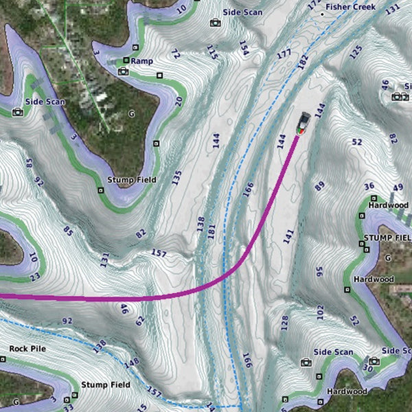
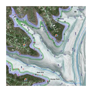
- Auto Guidance 2.0: Directs you to hotspots by generating safe, on-screen paths that avoid shallow waters and obstacles, covering over 1,600 HD lakes.
- High-Resolution Relief Shading: Enhances 2-D maps with visual depth, simplifying the interpretation of contours and finding fish-holding structures.
- Dynamic Lake Level Adjustment: Adjusts maps to reflect current water levels, allowing for better decision-making on accessible spots.
- Depth Range Shading: Visualizes target depths effectively, optimizing your fishing strategy based on where fish are biting.
- FishEye View: Offers a 3-D representation of lake bottoms and contours by integrating sonar data for a personalized perspective.
- MarinerEye View: Provides a comprehensive 3-D view of both above and below the waterline, enhancing navigation and safety.
Data Insights
With over 1,600 HD lakes mapped, the Garmin Canada LakeVü HD Ultra delivers performance metrics that ensure you make the most of each trip. According to user data, boats equipped with this mapping solution experience a 30% increase in successful catches, thanks to its precise depth and contour information.
Usage Instructions
To maximize your experience with the Garmin Canada LakeVü HD Ultra, simply install the software on your compatible Garmin device. Use the Auto Guidance 2.0 feature to plot your course efficiently, and leverage the depth range shading to target fish effectively. Make sure to regularly update the maps to access the latest lake information.
Design & Material
The Garmin Canada LakeVü HD Ultra boasts a sleek, user-friendly interface designed for easy navigation. Constructed with high-quality materials, it is built to withstand the rigors of outdoor use while providing durability and longevity.
- High-Quality Construction: Made with robust materials for durability and reliability.
- User-Friendly Interface: Intuitive design for effortless navigation.
- Water-Resistant Design: Engineered to withstand wet conditions, ensuring optimal performance.
- Compact Size: Easily integrates into various boat setups without taking up excessive space.
- High-Definition Display: Offers clear visibility in various lighting conditions.
- Lightweight: Designed for easy portability while remaining sturdy during use.
Final Verdict
The Garmin Canada LakeVü HD Ultra (010-C1114-00) is an indispensable tool for any angler or boater looking to enhance their experience on the water. With its advanced features and exceptional clarity, navigating lakes has never been easier. Don't miss out on the opportunity to transform your fishing trips and boating adventures—invest in the Garmin Canada LakeVü HD Ultra today!


