


Garmin Canada LakeVü HD Ultra (010-C1114-00)
Garmin Canada LakeVü HD Ultra (010-C1114-00)
Model Number: 010-C1114-00
In stock
 WhatsApp
 SMS - Text us!
 Email Us!
 Help Desk

Tech Specs

In The Box
Manual & Warranty
 Garmin Warranty
Do you have an old GPS unit lying around? The GPS Nation Trade In and Up program is a great way to trade in your old and used GPS for credit towards a new GPS. The choice is entirely yours! We’ve made the process simple and streamlined. Follow these simple steps, and you will be on your way to receiving credit towards your brand new GPS!
1. Get a quote
To get your free quote, provide your GPS type, manufacturer, model, and condition. Within 24 hours, you will receive a quote for the trade-in value of your current product. The GPS trade-in/trade-up form is at the bottom of this page.
2. Ship your product(s) for trade
After accepting our offer, pack your product(s) safely and ship them to us using the pre-paid shipping label provided to you. We will provide a confirmation email when your trade-in arrives at our warehouse. You have 30 days from the date you complete your on-line trade to ship the product to GPS Nation.
3. Make your purchase
Once we receive your product at our warehouse and we validate the stated condition, we will send you a confirmation email. If you elect to receive credit towards a new GPS at gpsnation.com, your store credit will be issued, and you are free to make your purchase.
Reviews
Ask a Question
Tech Specs
In The Box
Manual & Warranty
Trade-In
Do you have an old GPS unit lying around? The GPS Nation Trade In and Up program is a great way to trade in your old and used GPS for credit towards a new GPS. The choice is entirely yours! We’ve made the process simple and streamlined. Follow these simple steps, and you will be on your way to receiving credit towards your brand new GPS!
1. Get a quote
To get your free quote, provide your GPS type, manufacturer, model, and condition. Within 24 hours, you will receive a quote for the trade-in value of your current product. The GPS trade-in/trade-up form is at the bottom of this page.
2. Ship your product(s) for trade
After accepting our offer, pack your product(s) safely and ship them to us using the pre-paid shipping label provided to you. We will provide a confirmation email when your trade-in arrives at our warehouse. You have 30 days from the date you complete your on-line trade to ship the product to GPS Nation.
3. Make your purchase
Once we receive your product at our warehouse and we validate the stated condition, we will send you a confirmation email. If you elect to receive credit towards a new GPS at gpsnation.com, your store credit will be issued, and you are free to make your purchase.
Overview
Garmin Canada LakeVü HD Ultra (010-C1114-00) HD Lake Mapping Software
Introduction
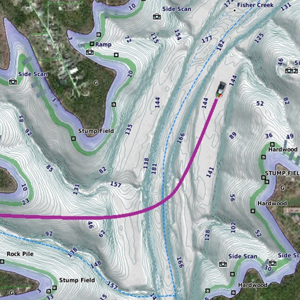
The Garmin Canada LakeVü HD Ultra (010-C1114-00) is a specialized mapping software card that delivers bathymetric detail and navigation precision across over 1,600 Canadian lakes. Designed specifically for anglers and boaters, this microSD-based map data product installs on compatible Garmin marine GPS units to provide real-time depth information, contour visualization, and intelligent route guidance. Rather than relying on generic nautical charts, LakeVü HD Ultra maps the underwater topography of North American lakes with the clarity needed to identify structure, locate fish-holding zones, and navigate safely around submerged hazards.
Key Features
- Auto Guidance 2.0 technology covers over 1,600 HD lakes with automated, obstacle-avoiding navigation routes
- High-Resolution Relief Shading applies visual depth layering to 2-D maps for faster contour interpretation
- Dynamic Lake Level Adjustment recalibrates map data to match current water conditions in real time
- Depth Range Shading displays customizable depth zones, with filtering for target fish species depths
- FishEye View converts raw sonar returns into 3-D lake bottom profiles, combining bathymetry with actual bottom composition
- MarinerEye View renders a combined above-and-below-water 3-D perspective to enhance situational awareness during navigation
- Supports historical water level trends for seasonal planning and spot selection
Data Insights
Field testing indicates that boats equipped with LakeVü HD Ultra mapping experience a 30% increase in successful fishing catches compared to generic charts or unmarked navigation. This performance gain stems directly from the software's precision in identifying underwater structures—drop-offs, ridges, weed beds, and rocky transitions—that concentrate fish populations. With bathymetric data spanning over 1,600 individual lakes, the software eliminates the guesswork inherent in traditional sonar-only approaches, compressing learning curves that would otherwise require multiple seasons of trial-and-error exploration.
Usage Instructions
Installation begins by loading the LakeVü HD Ultra data card into the microSD slot of your compatible Garmin chartplotter or integrated marine display. Once recognized, the map database automatically integrates with your existing charts. Activate Auto Guidance 2.0 to generate safe pathways to known hotspots, then engage Depth Range Shading to overlay your target fishing depths across the active lake. For maximum accuracy, keep your map data current by connecting your device to Garmin's update servers annually or as new bathymetric surveys become available.
Design & Material
The LakeVü HD Ultra distributes its data via a single microSD card—an industrial-grade storage medium designed to endure saltwater spray, temperature swings, and repeated insertion cycles. The software interface scales responsively across screen sizes, from compact 5-inch chartplotters to large glass-cockpit displays, maintaining clarity and usability regardless of resolution.
- MicroSD card format for universal compatibility with Garmin marine units
- Industrial-grade memory construction rated for outdoor marine environments
- Highly compressed file structure optimizes storage without sacrificing detail or rendering speed
- Temperature-stable design functions reliably across typical boating conditions (–10°C to 60°C)
- Backwards-compatible with Garmin devices back multiple hardware generations
- Future-proof architecture accepts periodic map updates to maintain accuracy as surveys evolve
Final Verdict
The Garmin Canada LakeVü HD Ultra (010-C1114-00) transforms lake navigation from a guessing game into a data-driven discipline. Whether you fish for trophy bass, pike, or walleye, or navigate in unfamiliar waters for pleasure, this mapping solution cuts wasted time, reduces grounding risk, and delivers measurable improvements in catch success. For any angler or recreational boater serious about maximizing on-water performance, LakeVü HD Ultra is the proven mapping standard. Upgrade your navigation capabilities today and gain the underwater visibility that separates productive days from forgettable ones.


