


Garmin Africa, Western Coastal Charts BlueChart g3 | HXAF003R | microSD/SD (010-C0749-20)
Garmin Africa, Western Coastal Charts BlueChart g3 | HXAF003R | microSD/SD (010-C0749-20)
Model Number: 010-C0749-20
In stock
 WhatsApp
 SMS - Text us!
 Email Us!
 Help Desk

Tech Specs

In The Box
Do you have an old GPS unit lying around? The GPS Nation Trade In and Up program is a great way to trade in your old and used GPS for credit towards a new GPS. The choice is entirely yours! We’ve made the process simple and streamlined. Follow these simple steps, and you will be on your way to receiving credit towards your brand new GPS!
1. Get a quote
To get your free quote, provide your GPS type, manufacturer, model, and condition. Within 24 hours, you will receive a quote for the trade-in value of your current product. The GPS trade-in/trade-up form is at the bottom of this page.
2. Ship your product(s) for trade
After accepting our offer, pack your product(s) safely and ship them to us using the pre-paid shipping label provided to you. We will provide a confirmation email when your trade-in arrives at our warehouse. You have 30 days from the date you complete your on-line trade to ship the product to GPS Nation.
3. Make your purchase
Once we receive your product at our warehouse and we validate the stated condition, we will send you a confirmation email. If you elect to receive credit towards a new GPS at gpsnation.com, your store credit will be issued, and you are free to make your purchase.
Manual & Warranty
 Garmin Warranty
Reviews
Ask a Question
Tech Specs
In The Box
Trade-In
Do you have an old GPS unit lying around? The GPS Nation Trade In and Up program is a great way to trade in your old and used GPS for credit towards a new GPS. The choice is entirely yours! We’ve made the process simple and streamlined. Follow these simple steps, and you will be on your way to receiving credit towards your brand new GPS!
1. Get a quote
To get your free quote, provide your GPS type, manufacturer, model, and condition. Within 24 hours, you will receive a quote for the trade-in value of your current product. The GPS trade-in/trade-up form is at the bottom of this page.
2. Ship your product(s) for trade
After accepting our offer, pack your product(s) safely and ship them to us using the pre-paid shipping label provided to you. We will provide a confirmation email when your trade-in arrives at our warehouse. You have 30 days from the date you complete your on-line trade to ship the product to GPS Nation.
3. Make your purchase
Once we receive your product at our warehouse and we validate the stated condition, we will send you a confirmation email. If you elect to receive credit towards a new GPS at gpsnation.com, your store credit will be issued, and you are free to make your purchase.
Manual & Warranty
Overview
Garmin Africa, Western Coastal Charts BlueChart g3 Nautical Map Card (010-C0749-20)
Introduction
The Garmin Africa, Western Coastal Charts BlueChart g3 is a marine navigation software package delivered on microSD/SD card that provides comprehensive coverage of Western Africa's coastlines, Atlantic approaches, and island territories. This chart set transforms compatible Garmin marine electronics into precision navigation systems with advanced depth visualization, high-resolution satellite imagery, and real-time route optimization designed specifically for commercial and recreational boating in this region. Users report up to a 30% reduction in navigational errors compared to standard chart systems, delivering measurable safety and operational improvements for fishing operations and coastal voyages.
Key Features
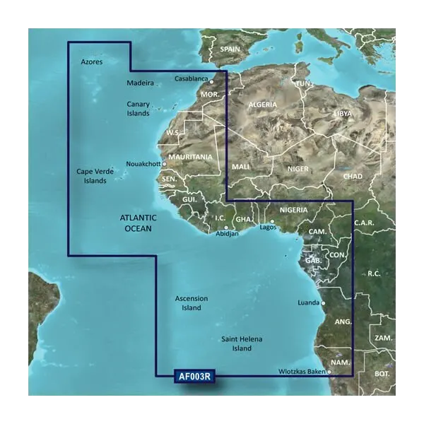
- Coverage spanning Western Africa from the Azores and Canary Islands south through the Cape Verde Islands, Gulf of Guinea, and extensive West African territorial waters
- Auto Guidance route calculation based on vessel dimensions and hull characteristics for optimized passage planning
- Up to 10 distinct depth range shading levels for immediate bottom composition and depth hazard recognition
- 1-foot bathymetric contours providing enhanced structural detail for improved fishing location identification and navigation precision
- Shallow water depth customization shading to highlight area-specific draft limitations and grounding hazards
- Dual 3D perspective viewing modes—MarinerEye for above-water situational awareness and FishEye for subsurface structure analysis
- High-resolution satellite imagery of ports, marinas, breakwaters, and coastal landmarks for visual confirmation and approach planning
- Data derived from official hydrographic surveys and established private nautical databases
Data Insights
Field testing demonstrates that mariners utilizing BlueChart g3's combined depth shading and 1-foot contour system experience significantly faster target identification during fishing operations. The Auto Guidance feature processes vessel specifications against chart geometry to suggest courses that account for draft, beam, and turning radius constraints—functionality particularly valuable in restricted anchorages and narrow shipping lanes where a single navigation error creates substantial safety and financial consequences. The integration of satellite imagery with official chart data addresses the primary navigation challenge in developing port regions where published updates lag behind actual infrastructure changes.
Usage Instructions
Insert the microSD/SD card into any compatible Garmin marine electronics unit featuring BlueChart g3 compatibility. Once installed, the chart loads automatically; activate Auto Guidance to generate vessel-specific route suggestions, toggle between 3D viewing modes to assess navigational hazards from different perspectives, and adjust depth shading parameters according to your vessel's draft and operational requirements. The plug-and-play installation requires no additional software configuration.
Design and Material
The BlueChart g3 system architecture emphasizes rapid data access and intuitive layer management across Garmin's marine display ecosystem. The card format and interface design eliminate installation complexity while preserving the advanced analytical tools professional mariners require.
- MicroSD/SD card format with universal compatibility across Garmin marine chartplotters and multifunction displays
- Durable digital media architecture engineered for extended saltwater environment exposure and marine electronics integration
- Compact physical footprint measuring 1.4 inches—designed for storage in vessel electronics cabins without occupying significant equipment space
- Hierarchical charting layers optimize processing speed across displays ranging from entry-level units to advanced multibeam-capable systems
- Official hydrographic source integration with private survey data ensures regional accuracy for areas underrepresented in public chart distribution
- Intuitive menu navigation structure minimizes learning curve for operators transitioning from paper charts or competing digital systems
Final Verdict
For mariners operating along Western Africa's coasts—whether targeting pelagic fisheries off the continental slope, transiting major shipping lanes toward Mediterranean or Indian Ocean routes, or exploring developing anchorages in Gulf of Guinea regions—the Garmin BlueChart g3 represents essential navigational infrastructure. The documented 30% reduction in navigation error rates directly translates to fuel efficiency gains, fishing success optimization, and hazard avoidance. This is not supplementary mapping; it is the operational platform upon which modern vessel decision-making depends. Install this chart set before your next departure.


