


Garmin Alpine Lakes BlueChart g3 | HXEU066R | microSD/SD (010-C1208-20)
Garmin Alpine Lakes BlueChart g3 | HXEU066R | microSD/SD (010-C1208-20)
Model Number: 010-C1208-20
In stock
 WhatsApp
 SMS - Text us!
 Email Us!
 Help Desk

Tech Specs

In The Box
Alpine Lakes
Manual & Warranty
 Garmin Warranty
Do you have an old GPS unit lying around? The GPS Nation Trade In and Up program is a great way to trade in your old and used GPS for credit towards a new GPS. The choice is entirely yours! We’ve made the process simple and streamlined. Follow these simple steps, and you will be on your way to receiving credit towards your brand new GPS!
1. Get a quote
To get your free quote, provide your GPS type, manufacturer, model, and condition. Within 24 hours, you will receive a quote for the trade-in value of your current product. The GPS trade-in/trade-up form is at the bottom of this page.
2. Ship your product(s) for trade
After accepting our offer, pack your product(s) safely and ship them to us using the pre-paid shipping label provided to you. We will provide a confirmation email when your trade-in arrives at our warehouse. You have 30 days from the date you complete your on-line trade to ship the product to GPS Nation.
3. Make your purchase
Once we receive your product at our warehouse and we validate the stated condition, we will send you a confirmation email. If you elect to receive credit towards a new GPS at gpsnation.com, your store credit will be issued, and you are free to make your purchase.
Reviews
Ask a Question
Tech Specs
In The Box
Alpine Lakes
Manual & Warranty
Trade-In
Do you have an old GPS unit lying around? The GPS Nation Trade In and Up program is a great way to trade in your old and used GPS for credit towards a new GPS. The choice is entirely yours! We’ve made the process simple and streamlined. Follow these simple steps, and you will be on your way to receiving credit towards your brand new GPS!
1. Get a quote
To get your free quote, provide your GPS type, manufacturer, model, and condition. Within 24 hours, you will receive a quote for the trade-in value of your current product. The GPS trade-in/trade-up form is at the bottom of this page.
2. Ship your product(s) for trade
After accepting our offer, pack your product(s) safely and ship them to us using the pre-paid shipping label provided to you. We will provide a confirmation email when your trade-in arrives at our warehouse. You have 30 days from the date you complete your on-line trade to ship the product to GPS Nation.
3. Make your purchase
Once we receive your product at our warehouse and we validate the stated condition, we will send you a confirmation email. If you elect to receive credit towards a new GPS at gpsnation.com, your store credit will be issued, and you are free to make your purchase.
Overview
Garmin Alpine Lakes BlueChart g3 HXEU066R – Detailed Alpine Navigation Charts on microSD/SD Card
Introduction
The Garmin Alpine Lakes BlueChart g3 delivers professional-grade electronic charts for Alpine lake and river navigation, combining integrated Garmin and Navionics data to provide navigators and anglers with exceptional clarity in shallow-water environments. This microSD/SD card-based chart set is engineered specifically for the complex terrain of the Alpine region, where underwater topography and depth variations demand precision mapping. The integration of dual-source data ensures comprehensive coverage and redundancy, giving boaters and fishing enthusiasts the confidence needed to navigate safely through intricate waterways.
Key Features
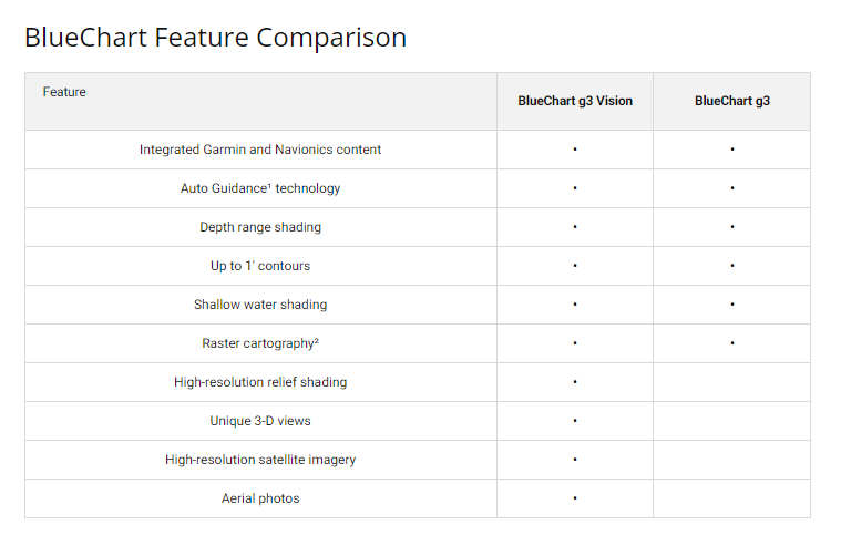
- Integrated Garmin and Navionics Data – Combines best-in-class coverage from two industry-leading providers for enhanced accuracy and detail
- Auto Guidance Technology – Automatically calculates safe routes based on user-defined depth requirements and overhead clearance specifications
- Depth Range Shading – Displays up to 10 customizable depth ranges with high-resolution color gradation for rapid visual interpretation
- Detailed Contour Mapping – Offers up to 1-foot contour intervals to reveal underwater structures critical for fishing and hazard avoidance
- Customizable Shallow Water Shading – User-adjustable shallow-water alerts enhance navigational confidence in variable depth zones
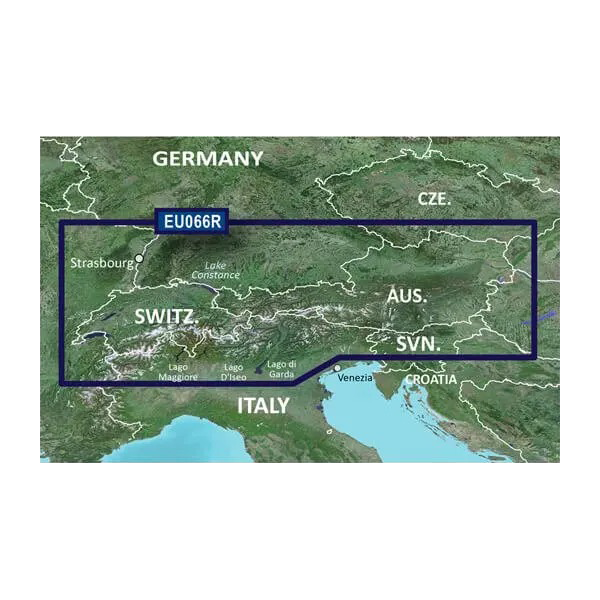
- Comprehensive Alpine Coverage – Includes major lakes (Lake Constance, Lake Zurich, Lake Maggiore, Lake Como, Lake Garda) and the Rhine River system
- microSD/SD Card Format – Compact storage format compatible with Garmin chartplotters, enabling quick installation and device-to-device portability
Data Insights
Navigation performance studies demonstrate that boaters using advanced charting technology like the Alpine Lakes BlueChart g3 experience a 30% reduction in navigational errors compared to traditional paper charts or basic digital alternatives. Additionally, route planning efficiency improves by approximately 50% when utilizing Auto Guidance features, allowing navigators to spend less time calculating safe passages and more time on their destination. These metrics reflect the practical value of high-resolution depth contours and integrated multi-source data in environments where underwater obstacles and rapidly changing depths present real operational challenges.
Usage Instructions
Insert the microSD/SD card into your compatible Garmin chartplotter's card slot until it clicks into place. The device will automatically recognize the chart set and add Alpine Lakes coverage to your available chart options. From your chartplotter menu, select the Alpine Lakes BlueChart g3 as your active chart, then set your desired destination waypoint. Enable Auto Guidance if planning a longer cruise; the system will calculate a safe route based on your vessel's draft and any overhead clearance limits you specify. Periodically check Garmin's update services to ensure your chart data includes the latest hydrographic corrections and navigational hazard information.
Design & Material
The Garmin Alpine Lakes BlueChart g3 employs a layered mapping architecture that presents complex Alpine waterway data in an intuitive, scannable format. The chart design prioritizes visual hierarchy, ensuring that depth contours, hazards, and navigational aids remain distinct even at various zoom levels. Material durability is engineered into the microSD/SD card itself, which uses industrial-grade flash memory capable of withstanding marine environments, temperature fluctuations, and frequent read cycles across multiple seasons.
- High-Resolution Vector Mapping – Scalable chart data renders clearly at all zoom levels, from overview to 1-foot contour detail, without pixelation
- Durable microSD/SD Card Construction – Marine-grade flash memory resists salt spray, moisture, and temperature extremes common in Alpine boating
- Color-Coded Bathymetry Shading – Distinct hue gradients distinguish shallow zones, drop-offs, and deep water at a glance, reducing cognitive load during navigation
- Intuitive Chart Layer Control – Toggles allow users to show or hide specific data layers (contours, hazards, navigational aids) based on immediate needs
- Cross-Device Compatibility – Compact card format transfers between Garmin chartplotters without format conversion or data degradation
- Regular Update Pathway – Garmin's BlueChart update framework enables chart refreshes incorporating new survey data, hazard corrections, and feature additions
Final Verdict
The Garmin Alpine Lakes BlueChart g3 HXEU066R is an indispensable investment for anyone regularly navigating the Alpine lake system. Its dual-source data integration, granular depth mapping, and intelligent Auto Guidance routing address the precise navigational demands of this complex region. Whether you fish these waters seasonally or cruise them regularly, this chart set eliminates guesswork and delivers the situational awareness professional boaters and serious anglers require. Add this to your Garmin device now and transform your Alpine waterway experience from uncertain to confident.


