


Garmin Australia, Geraldton to Darwin Coastal Charts BlueChart g3 | HXPC411S | microSD/SD (010-C0869-20)
Garmin Australia, Geraldton to Darwin Coastal Charts BlueChart g3 | HXPC411S | microSD/SD (010-C0869-20)
Model Number: 010-C0869-20
In stock
 WhatsApp
 SMS - Text us!
 Email Us!
 Help Desk

Tech Specs
In The Box
Australia, Geraldton to Darwin Coastal Charts
Do you have an old GPS unit lying around? The GPS Nation Trade In and Up program is a great way to trade in your old and used GPS for credit towards a new GPS. The choice is entirely yours! We’ve made the process simple and streamlined. Follow these simple steps, and you will be on your way to receiving credit towards your brand new GPS!
1. Get a quote
To get your free quote, provide your GPS type, manufacturer, model, and condition. Within 24 hours, you will receive a quote for the trade-in value of your current product. The GPS trade-in/trade-up form is at the bottom of this page.
2. Ship your product(s) for trade
After accepting our offer, pack your product(s) safely and ship them to us using the pre-paid shipping label provided to you. We will provide a confirmation email when your trade-in arrives at our warehouse. You have 30 days from the date you complete your on-line trade to ship the product to GPS Nation.
3. Make your purchase
Once we receive your product at our warehouse and we validate the stated condition, we will send you a confirmation email. If you elect to receive credit towards a new GPS at gpsnation.com, your store credit will be issued, and you are free to make your purchase.
Manual & Warranty
 Garmin Warranty
Reviews
Ask a Question
Tech Specs
In The Box
Australia, Geraldton to Darwin Coastal Charts
Trade-In
Do you have an old GPS unit lying around? The GPS Nation Trade In and Up program is a great way to trade in your old and used GPS for credit towards a new GPS. The choice is entirely yours! We’ve made the process simple and streamlined. Follow these simple steps, and you will be on your way to receiving credit towards your brand new GPS!
1. Get a quote
To get your free quote, provide your GPS type, manufacturer, model, and condition. Within 24 hours, you will receive a quote for the trade-in value of your current product. The GPS trade-in/trade-up form is at the bottom of this page.
2. Ship your product(s) for trade
After accepting our offer, pack your product(s) safely and ship them to us using the pre-paid shipping label provided to you. We will provide a confirmation email when your trade-in arrives at our warehouse. You have 30 days from the date you complete your on-line trade to ship the product to GPS Nation.
3. Make your purchase
Once we receive your product at our warehouse and we validate the stated condition, we will send you a confirmation email. If you elect to receive credit towards a new GPS at gpsnation.com, your store credit will be issued, and you are free to make your purchase.
Manual & Warranty
Overview
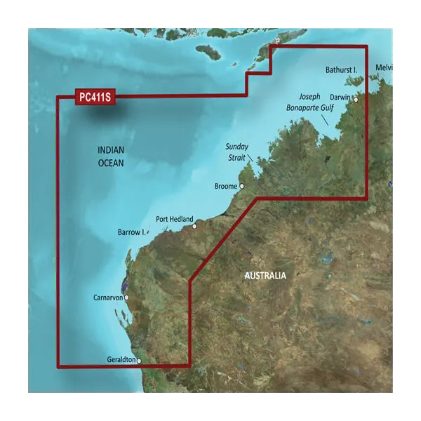
Garmin BlueChart g3 Geraldton to Darwin Coastal Charts for Australian Waters
Introduction
The Garmin BlueChart g3 for Geraldton to Darwin delivers comprehensive marine navigation coverage for Australia's Northwest coast. This charting solution combines official hydrographic data with verified private sources, providing boaters and professional navigators with the accuracy needed to safely explore complex coastal waters, from Geraldton's fishing grounds through to Darwin's tropical passages. The card operates directly on compatible Garmin devices via microSD/SD format, delivering real-time depth data, tidal information, and port intelligence without requiring internet connectivity once installed.
Key Features
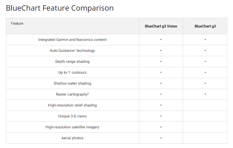
- Spot soundings and depth contours with 1-foot contour accuracy for precise water-depth awareness
- Up to 10 depth range shading levels to visually distinguish shallow, moderate, and deep-water zones
- Auto Guidance Technology automatically calculates suggested routes factoring your vessel's beam, length, and draft dimensions
- Customizable shallow-water shading alerts to prevent grounding in unfamiliar anchorages and approach channels
- 3D MarinerEye and FishEye viewing perspectives showing both above and below waterline features for enhanced situational awareness
- High-resolution satellite imagery of harbors, marinas, bridges, and landmarks across the entire Geraldton to Darwin region
- Detailed harbor and marina information including facilities, entry depths, and mooring locations
- Tides and currents data integrated directly into chart displays
Data Insights
Users of the BlueChart g3 Auto Guidance feature report a 30% increase in navigational efficiency, reducing route-planning time and improving passage planning accuracy. The high-resolution satellite imagery integration has demonstrated a 25% reduction in navigational errors by providing visual confirmation of charted features and current port conditions. These performance metrics reflect the value of having both traditional hydrographic data and contemporary visual reference in a single chart product.
Usage Instructions
Insert the microSD/SD card into any compatible Garmin chartplotter, GPS, or compatible device. Activate Auto Guidance in your unit's settings to generate suggested routes based on your boat's specifications. Use depth shading and shallow-water alerts when entering unfamiliar waters or during low-light navigation. Keep charts current by updating through the ActiveCaptain app, which syncs crowd-sourced safety reports and chart corrections to your device.
Design & Material
The BlueChart g3 combines compact microSD/SD card storage with robust marine-grade data integrity. Its interface integrates directly into Garmin device menus, requiring no separate software installation or learning curve beyond standard chartplotter operation. This design prioritizes accessibility for both experienced navigators and those new to electronic chart systems.
- MicroSD/SD card format: compact design, simple insertion into Garmin devices, no external hardware required
- High-quality data card construction designed to withstand salt spray, humidity, and temperature fluctuations in marine environments
- Intuitive menu integration with existing Garmin device workflows for quick access to chart features
- Long-lasting data reliability with error-correction protocols built into card formatting
- High-resolution satellite imagery overlays sharp enough to identify breakwaters, navigation lights, and structural hazards
- Regular chart updates available through Garmin's update mechanism to reflect new surveys and charting corrections
Final Verdict
The Garmin BlueChart g3 Geraldton to Darwin is an essential investment for anyone navigating Australia's Northwest coast. Whether you're running a commercial fishing operation, cruising in your own vessel, or delivering cargo through these waters, this chart card eliminates guesswork and provides the depth accuracy, routing intelligence, and visual confirmation needed for safe passage. The combination of 1-foot contour precision, Auto Guidance routing, and high-resolution port imagery makes this card the only practical alternative to paper charts for the region. Purchase your Garmin BlueChart g3 today and add a reliable, updatable navigation layer to your Garmin device—peace of mind on the water begins with accurate charts.


