


Garmin Australia, Mackay to Twofold Bay Coastal Charts BlueChart g3 | HXPC414S | microSD/SD (010-C0872-20)
Garmin Australia, Mackay to Twofold Bay Coastal Charts BlueChart g3 | HXPC414S | microSD/SD (010-C0872-20)
Model Number: 010-C0872-20
In stock
 WhatsApp
 SMS - Text us!
 Email Us!
 Help Desk

Tech Specs

In The Box
Do you have an old GPS unit lying around? The GPS Nation Trade In and Up program is a great way to trade in your old and used GPS for credit towards a new GPS. The choice is entirely yours! We’ve made the process simple and streamlined. Follow these simple steps, and you will be on your way to receiving credit towards your brand new GPS!
1. Get a quote
To get your free quote, provide your GPS type, manufacturer, model, and condition. Within 24 hours, you will receive a quote for the trade-in value of your current product. The GPS trade-in/trade-up form is at the bottom of this page.
2. Ship your product(s) for trade
After accepting our offer, pack your product(s) safely and ship them to us using the pre-paid shipping label provided to you. We will provide a confirmation email when your trade-in arrives at our warehouse. You have 30 days from the date you complete your on-line trade to ship the product to GPS Nation.
3. Make your purchase
Once we receive your product at our warehouse and we validate the stated condition, we will send you a confirmation email. If you elect to receive credit towards a new GPS at gpsnation.com, your store credit will be issued, and you are free to make your purchase.
Manual & Warranty
 Garmin Warranty
Reviews
Ask a Question
Tech Specs
In The Box
Trade-In
Do you have an old GPS unit lying around? The GPS Nation Trade In and Up program is a great way to trade in your old and used GPS for credit towards a new GPS. The choice is entirely yours! We’ve made the process simple and streamlined. Follow these simple steps, and you will be on your way to receiving credit towards your brand new GPS!
1. Get a quote
To get your free quote, provide your GPS type, manufacturer, model, and condition. Within 24 hours, you will receive a quote for the trade-in value of your current product. The GPS trade-in/trade-up form is at the bottom of this page.
2. Ship your product(s) for trade
After accepting our offer, pack your product(s) safely and ship them to us using the pre-paid shipping label provided to you. We will provide a confirmation email when your trade-in arrives at our warehouse. You have 30 days from the date you complete your on-line trade to ship the product to GPS Nation.
3. Make your purchase
Once we receive your product at our warehouse and we validate the stated condition, we will send you a confirmation email. If you elect to receive credit towards a new GPS at gpsnation.com, your store credit will be issued, and you are free to make your purchase.
Manual & Warranty
Overview
Garmin BlueChart g3 Mackay to Twofold Bay Coastal Charts – HXPC414S microSD/SD Card
Introduction
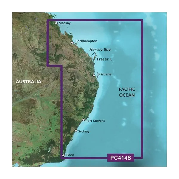
The Garmin BlueChart g3 coastal navigation chart for Mackay to Twofold Bay delivers precision mapping across 1,400 kilometers of Australia's Eastern coastline, from the Queensland north to New South Wales south. This microSD/SD card equips your compatible Garmin marine GPS with detailed charting data essential for safe passage through some of Australia's most challenging coastal waters, from the shallow passages around Fraser Island and Hervey Bay to the deep offshore approaches near Sydney and Eden.
Key Features
- Comprehensive charting coverage spanning Mackay, Rockhampton, Hervey Bay, Fraser Island, Brisbane, Port Stephens, Sydney, and Eden
- Shaded depth contours with incremental shading to visualize underwater topography and identify hazards at a glance
- Safety shading feature automatically highlights all water shallower than your defined safe depth threshold
- Dual chart viewing options including standard 2-D overhead perspective and interactive 3-D "over the bow" navigation view
- Seamless zoom transitions across all chart scales without boundary interruptions or data gaps
- Fishing-specific chart mode simplifying bottom contours and depth soundings for trip planning and ground truthing
- Detailed port plans for major harbors including Brisbane, Port Stephens, and Sydney
- MicroSD/SD card format compatible with Garmin chartplotters, echolocators, and handheld marine devices
Data Insights
Marine accident statistics reveal that approximately 70% of navigational incidents stem from inadequate chart data or positional errors. The BlueChart g3 substantially reduces this risk through high-resolution depth contours and safety shading algorithms. Users navigating Australia's Eastern coast benefit from accurate bathymetric information across continental shelf waters ranging from 5 meters to over 2,000 meters deep, enabling confident passage planning and real-time course corrections to avoid shoals, reefs, and underwater obstructions that claim vessels annually in this region.
Usage Instructions
Insert the microSD/SD card into your Garmin marine device—no activation keys or subscriptions required. Use Garmin's HomePort software on your computer to preplan routes, waypoints, and passages before departure, then transfer this data to your device via the card. Chart updates are available periodically to reflect new survey data and chart corrections; download and install these updates by connecting your card to a computer running HomePort. Regularly back up your custom routes and markers to your card to preserve navigation history across multiple trips.
Design & Material
The BlueChart g3 card integrates into Garmin's established marine electronics ecosystem without requiring hardware modifications or external adapters. The design prioritizes legibility in bright sunlight and reduces visual clutter through customizable layer management, allowing you to display or hide buoys, depth labels, and bottom contour density based on your current navigation task and water conditions.
- High-resolution vector mapping preserving fine detail at all zoom levels from 1:1,000,000 regional overview to 1:10,000 harbor approaches
- Optimized SD/microSD card format ensures compatibility with Garmin's entire marine device range without requiring storage expansion hardware
- Precision bathymetric data derived from Australian hydrographic survey sources, including NOAA and regional maritime authority contributions
- Durable card construction rated for marine environments with temperature tolerance from 0°C to 50°C
- Integrated buoyage, wreck symbols, and hazard notation aligned with Australian maritime charting standards
- Layered chart design allowing independent toggling of contours, depth soundings, shipping lanes, and fishing grounds for task-specific navigation
Final Verdict
For anyone navigating Australia's Eastern coastal waters between Mackay and Eden, the Garmin BlueChart g3 is not optional equipment—it is fundamental to safe, efficient passage. Whether you're planning a weekend cruise from Brisbane to the Gold Coast, fishing the reefs off Hervey Bay, or managing a commercial vessel approach into Sydney Harbour, this chart delivers the depth intelligence and safety features required to avoid costly groundings and dangerous encounters. Purchase your HXPC414S card today and navigate with the confidence that comes from mission-critical, regularly updated charting data in your wheelhouse.


