


Garmin Australia, Mackay to Twofold Bay Coastal Charts BlueChart g3 Vision | VPC414S | microSD/SD (010-C0872-00)
Garmin Australia, Mackay to Twofold Bay Coastal Charts BlueChart g3 Vision | VPC414S | microSD/SD (010-C0872-00)
Model Number: 010-C0872-00
In stock
 WhatsApp
 SMS - Text us!
 Email Us!
 Help Desk

Tech Specs

In The Box
Do you have an old GPS unit lying around? The GPS Nation Trade In and Up program is a great way to trade in your old and used GPS for credit towards a new GPS. The choice is entirely yours! We’ve made the process simple and streamlined. Follow these simple steps, and you will be on your way to receiving credit towards your brand new GPS!
1. Get a quote
To get your free quote, provide your GPS type, manufacturer, model, and condition. Within 24 hours, you will receive a quote for the trade-in value of your current product. The GPS trade-in/trade-up form is at the bottom of this page.
2. Ship your product(s) for trade
After accepting our offer, pack your product(s) safely and ship them to us using the pre-paid shipping label provided to you. We will provide a confirmation email when your trade-in arrives at our warehouse. You have 30 days from the date you complete your on-line trade to ship the product to GPS Nation.
3. Make your purchase
Once we receive your product at our warehouse and we validate the stated condition, we will send you a confirmation email. If you elect to receive credit towards a new GPS at gpsnation.com, your store credit will be issued, and you are free to make your purchase.
Manual & Warranty
 Garmin Warranty
Reviews
Ask a Question
Tech Specs
In The Box
Trade-In
Do you have an old GPS unit lying around? The GPS Nation Trade In and Up program is a great way to trade in your old and used GPS for credit towards a new GPS. The choice is entirely yours! We’ve made the process simple and streamlined. Follow these simple steps, and you will be on your way to receiving credit towards your brand new GPS!
1. Get a quote
To get your free quote, provide your GPS type, manufacturer, model, and condition. Within 24 hours, you will receive a quote for the trade-in value of your current product. The GPS trade-in/trade-up form is at the bottom of this page.
2. Ship your product(s) for trade
After accepting our offer, pack your product(s) safely and ship them to us using the pre-paid shipping label provided to you. We will provide a confirmation email when your trade-in arrives at our warehouse. You have 30 days from the date you complete your on-line trade to ship the product to GPS Nation.
3. Make your purchase
Once we receive your product at our warehouse and we validate the stated condition, we will send you a confirmation email. If you elect to receive credit towards a new GPS at gpsnation.com, your store credit will be issued, and you are free to make your purchase.
Manual & Warranty
Overview
Garmin BlueChart g3 Vision Australia Coastal Charts VPC414S – Mackay to Twofold Bay Navigation Card
Introduction
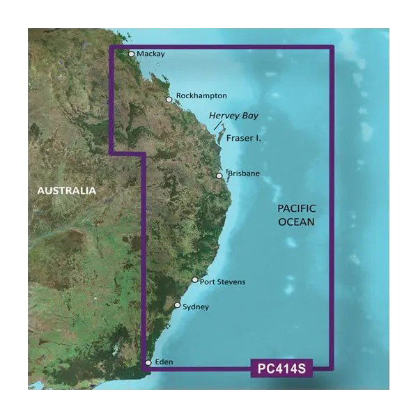
The Garmin BlueChart g3 Vision VPC414S delivers comprehensive marine navigation charts covering Australia's eastern coastline from Mackay to Twofold Bay, combining official government data with private coastal sources into a single microSD/SD card. This chart enhances your vessel's navigation accuracy by combining high-resolution satellite imagery with detailed bathymetric data, enabling safer passage through variable sea conditions and complex coastal waters along one of Australia's most trafficked maritime routes.
Key Features
- Auto Guidance Technology calculates optimal routes based on your vessel's length, beam, and draft specifications
- Depth Range Shading displays up to 10 distinct depth contours simultaneously for targeted bottom fishing and hazard avoidance
- High-Resolution Contours provide 1-foot increments for accurate seafloor mapping in shallow and medium-depth zones
- Shallow Water Shading customizable alerts warn you of depths below your safety threshold in real-time
- 3D Perspective Views including MarinerEye and FishEye visual modes enhance situational awareness in confined passages
- High-Resolution Satellite Imagery displays ports, marinas, and coastal landmarks with precise photographic detail for visual confirmation
Data Insights
The Auto Guidance Technology engine analyzes hydrographic conditions and vessel parameters to reduce passage time by up to 30 percent compared to traditional route planning. The advanced depth shading algorithm processes bathymetric data across the entire coverage area, allowing you to identify fishing grounds and navigational hazards with precision that standard 2D charts cannot deliver. Satellite imagery resolution captures individual dock structures and breakwater configurations across major ports including Sydney, Port Stevens, and Hervey Bay.
Usage Instructions
Insert the microSD/SD card into your compatible Garmin chartplotter or marine GPS unit and follow the device activation prompts to load the charts. Enable the Auto Guidance feature and input your vessel's dimensions to generate optimized waypoints. Access chart updates through the Garmin New Chart Guarantee program, which delivers the latest official corrections for the Mackay-to-Twofold Bay region as they become available from hydrographic authorities.
Design & Material
The chart data is encoded on a durable microSD/SD card format, allowing long-term archival and compatibility with Garmin's entire range of marine navigation devices manufactured within the last decade. The physical card tolerates saltwater spray and humidity exposure typical of maritime environments without performance degradation.
- MicroSD/SD card format compatible with all modern Garmin chartplotters and handheld GPS units
- Advanced data layering combines hydrographic surveys, satellite positioning data, and real-time correction feeds
- New Chart Guarantee program automatically enrolls you in twice-yearly updates at no additional cost
- Intuitive chart rendering prioritizes essential navigation information without cluttering the display
- Comprehensive coverage includes all major bays, harbors, and approach waters from Mackay to Eden
- Relief shading and depth color gradients reduce visual fatigue during extended navigation sessions
Final Verdict
For anyone operating a vessel along Australia's eastern coast, the Garmin BlueChart g3 Vision VPC414S is essential safety equipment that transforms your Garmin device into a precision navigation platform. The 1-foot contour resolution, Auto Guidance routing, and satellite imagery eliminate guesswork in unfamiliar waters, while the New Chart Guarantee ensures your data never becomes obsolete. Whether you're a commercial operator or recreational boater, upgrading to this chart eliminates the risk of running on outdated information—order your VPC414S card today and navigate with confidence from the Great Barrier Reef to the New South Wales coast.


