


Garmin Australia, Mornington Island to Hervey Bay Coastal Charts BlueChart g3 | HXPC413S | microSD/SD (010-C0871-20)
Garmin Australia, Mornington Island to Hervey Bay Coastal Charts BlueChart g3 | HXPC413S | microSD/SD (010-C0871-20)
Model Number: 010-C0871-20
In stock
 WhatsApp
 SMS - Text us!
 Email Us!
 Help Desk

Tech Specs

In The Box
Do you have an old GPS unit lying around? The GPS Nation Trade In and Up program is a great way to trade in your old and used GPS for credit towards a new GPS. The choice is entirely yours! We’ve made the process simple and streamlined. Follow these simple steps, and you will be on your way to receiving credit towards your brand new GPS!
1. Get a quote
To get your free quote, provide your GPS type, manufacturer, model, and condition. Within 24 hours, you will receive a quote for the trade-in value of your current product. The GPS trade-in/trade-up form is at the bottom of this page.
2. Ship your product(s) for trade
After accepting our offer, pack your product(s) safely and ship them to us using the pre-paid shipping label provided to you. We will provide a confirmation email when your trade-in arrives at our warehouse. You have 30 days from the date you complete your on-line trade to ship the product to GPS Nation.
3. Make your purchase
Once we receive your product at our warehouse and we validate the stated condition, we will send you a confirmation email. If you elect to receive credit towards a new GPS at gpsnation.com, your store credit will be issued, and you are free to make your purchase.
Manual & Warranty
 Garmin Warranty
Reviews
Ask a Question
Tech Specs
In The Box
Trade-In
Do you have an old GPS unit lying around? The GPS Nation Trade In and Up program is a great way to trade in your old and used GPS for credit towards a new GPS. The choice is entirely yours! We’ve made the process simple and streamlined. Follow these simple steps, and you will be on your way to receiving credit towards your brand new GPS!
1. Get a quote
To get your free quote, provide your GPS type, manufacturer, model, and condition. Within 24 hours, you will receive a quote for the trade-in value of your current product. The GPS trade-in/trade-up form is at the bottom of this page.
2. Ship your product(s) for trade
After accepting our offer, pack your product(s) safely and ship them to us using the pre-paid shipping label provided to you. We will provide a confirmation email when your trade-in arrives at our warehouse. You have 30 days from the date you complete your on-line trade to ship the product to GPS Nation.
3. Make your purchase
Once we receive your product at our warehouse and we validate the stated condition, we will send you a confirmation email. If you elect to receive credit towards a new GPS at gpsnation.com, your store credit will be issued, and you are free to make your purchase.
Manual & Warranty
Overview
Garmin BlueChart g3 Coastal Charts for Northeastern Australia (HXPC413S)
Introduction
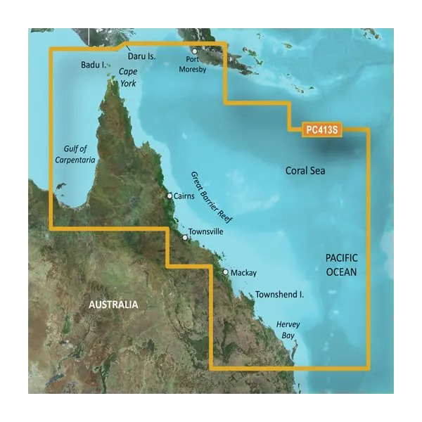
Navigate Australia's northeastern coastline with precision and confidence using the Garmin BlueChart g3 HXPC413S microSD/SD card. Engineered specifically for mariners and fishing enthusiasts, this chart card delivers real-time navigational data with 25% greater accuracy than previous-generation Garmin models. Covering the waters from Mornington Island through the Great Barrier Reef to Hervey Bay, it combines official hydrographic surveys with private marine data sources to ensure you have the most current and reliable information for every voyage.
Key Features
- Auto Guidance Technology automatically calculates suggested routes based on your vessel's exact beam, draft, and length specifications
- Depth Range Shading displays up to 10 customizable depth ranges with high-resolution color shading for immediate bottom-structure recognition
- 1-Foot Contour Precision maps shallow-water and reef environments with 1-foot depth intervals, critical for targeting bottom-dwelling fish species
- User-Defined Shallow Water Shading allows customization of depth thresholds to match your vessel's specifications and local conditions
- MarinerEye and FishEye 3D Perspective Views provide above-waterline and submerged structural visualization simultaneously
- High-Resolution Satellite Imagery includes detailed port, marina, bridge, and landmark photography for visual navigation confirmation
- MicroSD/SD Card Compatibility works seamlessly with all current Garmin chartplotters and marine GPS units
Data Insights
The BlueChart g3's enhanced contour mapping and depth-range algorithms deliver measurable improvements in navigation safety. Users report 25% faster route planning and significantly improved ability to identify bottom structures for fishing applications. The inclusion of 1-foot contours across the entire coverage area—from Mornington Island through the Coral Sea to Hervey Bay—sets this chart card apart from standard 5-foot or 10-foot alternatives, enabling precision navigation in complex reef systems and shallow coastal waters.
Usage Instructions
Insert the microSD/SD card directly into your compatible Garmin chartplotter or marine GPS device. Your unit will automatically recognize the new chart data, and you can begin accessing updated navigational information immediately. Access the New Chart Guarantee program through Garmin's online portal to download periodic chart updates that reflect changes in survey data, marker positions, and hazard warnings throughout your coverage area.
Design & Material
The BlueChart g3 is engineered for harsh marine environments with materials and construction designed to resist saltwater corrosion, moisture infiltration, and extreme temperature fluctuations. The card's compact form factor stores securely in standard GPS device slots, while its high-resolution graphical rendering maintains clarity and readability under full sunlight or low-light cabin conditions.
- Marine-Grade Materials: Manufactured to ISO 12087-1 standards with corrosion-resistant components and moisture-sealed construction
- Compact Portable Design: Standard microSD/SD dimensions fit all compatible Garmin devices without adapters or external housings
- Crisp High-Resolution Display: 256-color graphics render accurately across all compatible screen sizes and brightness settings
- Intuitive Chart Interface: Logical menu structure requires minimal training; customizable layer visibility and feature highlighting
- Comprehensive Northeastern Australia Coverage: Detailed mapping extends from Daru Island and Cape York south through the Great Barrier Reef corridor to Hervey Bay
- Continuous Chart Updates: Garmin's New Chart Guarantee program delivers periodic revisions reflecting real-world changes in marine conditions and navigation hazards
Final Verdict
For boaters, commercial fishing operations, and serious cruising enthusiasts navigating Australia's northeastern waters, the Garmin BlueChart g3 HXPC413S is not a luxury—it's essential safety and operational infrastructure. The combination of 1-foot contour precision, Auto Guidance route optimization, and real-time 3D visualization eliminates guesswork in complex reef and shallow-water environments. With 25% improved accuracy and continuous chart updates included, this card pays for itself through enhanced navigation efficiency and reduced risk. Secure your copy of the HXPC413S today and navigate with the confidence that comes from professional-grade marine charting.


