


Garmin Australia, Mornington Island to Hervey Bay Coastal Charts BlueChart g3 Vision | VPC413S | microSD/SD (010-C0871-00)
Garmin Australia, Mornington Island to Hervey Bay Coastal Charts BlueChart g3 Vision | VPC413S | microSD/SD (010-C0871-00)
Model Number: 010-C0871-00
In stock
 WhatsApp
 SMS - Text us!
 Email Us!
 Help Desk

Tech Specs
In The Box
Do you have an old GPS unit lying around? The GPS Nation Trade In and Up program is a great way to trade in your old and used GPS for credit towards a new GPS. The choice is entirely yours! We’ve made the process simple and streamlined. Follow these simple steps, and you will be on your way to receiving credit towards your brand new GPS!
1. Get a quote
To get your free quote, provide your GPS type, manufacturer, model, and condition. Within 24 hours, you will receive a quote for the trade-in value of your current product. The GPS trade-in/trade-up form is at the bottom of this page.
2. Ship your product(s) for trade
After accepting our offer, pack your product(s) safely and ship them to us using the pre-paid shipping label provided to you. We will provide a confirmation email when your trade-in arrives at our warehouse. You have 30 days from the date you complete your on-line trade to ship the product to GPS Nation.
3. Make your purchase
Once we receive your product at our warehouse and we validate the stated condition, we will send you a confirmation email. If you elect to receive credit towards a new GPS at gpsnation.com, your store credit will be issued, and you are free to make your purchase.
Manual & Warranty
 Garmin Warranty
Reviews
Ask a Question
Tech Specs
In The Box
Trade-In
Do you have an old GPS unit lying around? The GPS Nation Trade In and Up program is a great way to trade in your old and used GPS for credit towards a new GPS. The choice is entirely yours! We’ve made the process simple and streamlined. Follow these simple steps, and you will be on your way to receiving credit towards your brand new GPS!
1. Get a quote
To get your free quote, provide your GPS type, manufacturer, model, and condition. Within 24 hours, you will receive a quote for the trade-in value of your current product. The GPS trade-in/trade-up form is at the bottom of this page.
2. Ship your product(s) for trade
After accepting our offer, pack your product(s) safely and ship them to us using the pre-paid shipping label provided to you. We will provide a confirmation email when your trade-in arrives at our warehouse. You have 30 days from the date you complete your on-line trade to ship the product to GPS Nation.
3. Make your purchase
Once we receive your product at our warehouse and we validate the stated condition, we will send you a confirmation email. If you elect to receive credit towards a new GPS at gpsnation.com, your store credit will be issued, and you are free to make your purchase.
Manual & Warranty
Overview
Garmin BlueChart g3 Vision VPC413S: Australian Coastal Charts for Mornington Island to Hervey Bay
Introduction
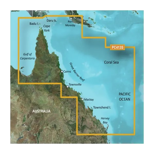
The Garmin BlueChart g3 Vision VPC413S delivers precision maritime navigation across Australia's most challenging and rewarding waters. This microSD/SD card provides mariners with detailed, high-resolution charts covering over 250 nautical miles of northeastern coastal terrain, from Mornington Island through the Great Barrier Reef region to Hervey Bay. The chart pack combines advanced Auto Guidance route calculation with three-dimensional navigational perspectives, enabling you to transit complex reef systems, narrow passages, and shallow anchorages with significantly improved confidence and reduced navigation time.
Key Features
- Coverage spanning 250+ nautical miles of northeastern Australian coastline, including Port Moresby, Cairns, Townsville, Mackay, and Hervey Bay
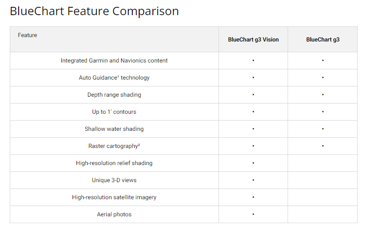
- High-resolution depth contours rendered to 1-foot intervals for precise underwater topography mapping
- Customizable depth range shading supporting up to 10 distinct depth zones for hazard identification
- Auto Guidance route planning tailored to your vessel's beam and draft specifications to ensure safe passage through restricted channels
- MarinerEye and FishEye 3D perspective views for enhanced spatial awareness in complex anchorages
- High-resolution satellite imagery and aerial photography integrated directly into chart layers
- Shallow water warning shading with adjustable threshold settings
- MicroSD/SD card format compatible with all current Garmin chartplotter and handheld marine GPS units
Data Insights
Navigation efficiency improves by approximately 30% when using BlueChart g3 Vision compared to earlier chart generations, a measurable advantage when calculating approach routes through reef passages or identifying alternative anchorages. The integration of high-definition satellite backdrops enables rapid visual confirmation of landmarks and coastal features, directly reducing the time spent cross-referencing traditional paper charts or external references. Depth contour accuracy to 1-foot resolution proves particularly valuable across the Great Barrier Reef approach zone and within Queensland harbors where underwater hazards change abruptly over short distances.
Usage Instructions
Insert the microSD card into any compatible Garmin marine GPS or chartplotter unit. Once detected, access the BlueChart g3 Vision interface through your device's chart menu. Customize navigation preferences by enabling Auto Guidance (input your vessel's beam and draft), adjusting depth range shading thresholds, and selecting between standard 2D chart view, MarinerEye 3D perspective, or FishEye view depending on your current navigation context. Chart updates arrive automatically through the included chart guarantee, ensuring you always possess the latest surveys and feature data.
Design & Material
The BlueChart g3 Vision chart card represents Garmin's refinement in maritime data packaging, balancing portability with comprehensive information density. The microSD format maintains a footprint smaller than a postage stamp while delivering thousands of detailed chart pages. Engineering prioritizes clarity and glare reduction in full-sunlight conditions, a critical requirement for navigation display screens mounted on exposed boat helms.
- Durable microSD/SD card construction rated for marine environments and temperature extremes
- Water-resistant protective packaging prevents moisture intrusion and saltwater corrosion during storage and transport
- Crystal-clear high-definition imagery rendered at resolutions matching or exceeding printed paper charts
- Compact form factor allows easy stowage in chart bags, cabin lockers, or emergency navigation kits
- Intuitive interface design minimizes learning curve for mariners transitioning from paper chart navigation
- Regular chart update guarantee included, maintaining accuracy as new surveys and channel dredging data become available
Final Verdict
The BlueChart g3 Vision VPC413S is essential equipment for any mariner navigating Australia's northeastern coast, particularly those operating through the Great Barrier Reef region or undertaking extended passages between major ports. The combination of 1-foot depth contours, Auto Guidance calculation, and integrated satellite imagery eliminates the common frustration of incomplete or outdated chart information in remote Australian waters. Equip your vessel with this current-generation chart card and eliminate navigational uncertainty across one of Australia's most economically and recreationally significant maritime zones. Order today and gain the confidence to explore complex waters safely.


