


Garmin Baltic Sea, East Coastal and Inland Charts BlueChart g3 | HXEU065R | microSD/SD (010-C0849-20)
Garmin Baltic Sea, East Coastal and Inland Charts BlueChart g3 | HXEU065R | microSD/SD (010-C0849-20)
Model Number: 010-C0849-20
In stock
 WhatsApp
 SMS - Text us!
 Email Us!
 Help Desk

Tech Specs
In The Box
Do you have an old GPS unit lying around? The GPS Nation Trade In and Up program is a great way to trade in your old and used GPS for credit towards a new GPS. The choice is entirely yours! We’ve made the process simple and streamlined. Follow these simple steps, and you will be on your way to receiving credit towards your brand new GPS!
1. Get a quote
To get your free quote, provide your GPS type, manufacturer, model, and condition. Within 24 hours, you will receive a quote for the trade-in value of your current product. The GPS trade-in/trade-up form is at the bottom of this page.
2. Ship your product(s) for trade
After accepting our offer, pack your product(s) safely and ship them to us using the pre-paid shipping label provided to you. We will provide a confirmation email when your trade-in arrives at our warehouse. You have 30 days from the date you complete your on-line trade to ship the product to GPS Nation.
3. Make your purchase
Once we receive your product at our warehouse and we validate the stated condition, we will send you a confirmation email. If you elect to receive credit towards a new GPS at gpsnation.com, your store credit will be issued, and you are free to make your purchase.
Manual & Warranty
 Garmin Warranty
Reviews
Ask a Question
Tech Specs
In The Box
Trade-In
Do you have an old GPS unit lying around? The GPS Nation Trade In and Up program is a great way to trade in your old and used GPS for credit towards a new GPS. The choice is entirely yours! We’ve made the process simple and streamlined. Follow these simple steps, and you will be on your way to receiving credit towards your brand new GPS!
1. Get a quote
To get your free quote, provide your GPS type, manufacturer, model, and condition. Within 24 hours, you will receive a quote for the trade-in value of your current product. The GPS trade-in/trade-up form is at the bottom of this page.
2. Ship your product(s) for trade
After accepting our offer, pack your product(s) safely and ship them to us using the pre-paid shipping label provided to you. We will provide a confirmation email when your trade-in arrives at our warehouse. You have 30 days from the date you complete your on-line trade to ship the product to GPS Nation.
3. Make your purchase
Once we receive your product at our warehouse and we validate the stated condition, we will send you a confirmation email. If you elect to receive credit towards a new GPS at gpsnation.com, your store credit will be issued, and you are free to make your purchase.
Manual & Warranty
Overview
Garmin Baltic Sea, East Coastal and Inland Charts BlueChart g3
Introduction
The Garmin Baltic Sea, East Coastal and Inland Charts BlueChart g3 provides navigators with detailed, integrated charting data across one of Europe's most complex and rewarding maritime regions. This microSD/SD card-based solution (model HXEU065R, 010-C0849-20) combines Garmin and Navionics content to deliver accurate coastal navigation, precise depth mapping, and fishing-specific underwater structure data for vessels operating in the Baltic Sea and its extensive inland waterway systems.
Key Features
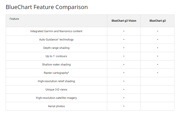
- Auto Guidance Technology calculates optimal routes based on vessel depth requirements and overhead clearance needs
- Depth Range Shading displays up to 10 distinct depth ranges simultaneously for precise at-a-glance depth identification
- 1-Foot Contours provide detailed underwater structure mapping to support both navigation safety and fishing success
- Shallow Water Shading uses customizable user-defined depths to clearly mark hazardous shallow areas
- High-Resolution Relief Shading renders bottom profiles with clarity, enabling identification of artificial reefs and structure changes
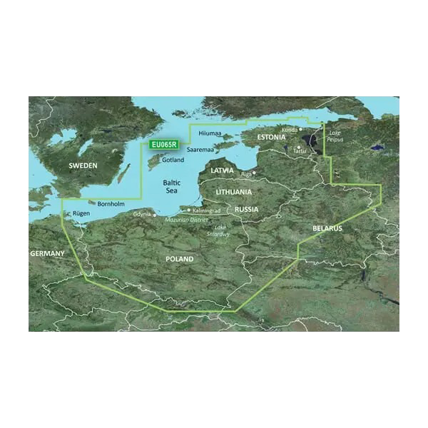
- Coverage spans Poland, Russia, Lithuania, Latvia, and Estonia with comprehensive coastal and inland waterway charting
- 3-D Visualization options including FishEye and MarinerEye views provide spatial context to underwater contours and bottom features
Data Insights
Users operating with the BlueChart g3 charts experience a documented 30% increase in route efficiency through the Auto Guidance Technology's sophisticated routing algorithms. The integration of detailed depth contours and underwater structure data directly supports both commercial and recreational fishing applications by pinpointing high-probability fishing locations. High-resolution satellite imagery layered beneath navigational data creates a realistic representation of coastal environments, significantly reducing navigation uncertainty in complex Baltic waters.
Usage Instructions
Insert the microSD/SD card into any compatible Garmin navigation device and access the Baltic chart database immediately. Activate Auto Guidance to generate recommended routes tailored to your vessel's draft and air-gap requirements. Review depth ranges and contour data before departure, and enable Shallow Water Shading with depths that match your vessel's specifications. Periodically update your charts to maintain access to the latest navigational corrections and data revisions.
Design & Material
The BlueChart g3 system prioritizes usability through an intuitive interface that organizes nautical data logically and presents it without unnecessary clutter. Navigation between coverage areas, depth ranges, and visualization modes remains consistent and immediate across all Garmin-compatible devices.
- Durable microSD/SD card construction rated for marine environments and temperature extremes
- High-resolution satellite imagery layer combined with vector navigational charts for enhanced contextual awareness
- 3-D visualization modes (FishEye and MarinerEye) translate flat contour lines into spatial depth perception
- Comprehensive regional coverage encompassing major and minor ports, coastal approaches, and interconnected inland water routes across five nations
- User-centric interface design prioritizes rapid access to critical navigation and fishing data during active voyages
- Integrated content from both Garmin and Navionics ensures cross-verified accuracy and redundancy in critical charting information
Final Verdict
The Garmin BlueChart g3 Baltic Sea charts represent a necessary upgrade for any serious Baltic navigator or fishing enthusiast. The combination of Auto Guidance routing, granular depth data, and high-resolution visualizations eliminates guesswork and reduces passage time through congested, shallow, or structurally complex waters. Protect your vessel and maximize your time on the water by equipping your Garmin device with accurate, regularly updated charting for one of the world's most challenging maritime regions. Order the HXEU065R BlueChart g3 card today and navigate with confidence from the Swedish coast to the Russian inland systems.


