


Garmin Baltic Sea, East Coastal and Inland Charts BlueChart g3 Vision | VEU065R | microSD/SD (010-C0849-00)
Garmin Baltic Sea, East Coastal and Inland Charts BlueChart g3 Vision | VEU065R | microSD/SD (010-C0849-00)
Model Number: 010-C0849-00
In stock
 WhatsApp
 SMS - Text us!
 Email Us!
 Help Desk

Tech Specs

In The Box
Do you have an old GPS unit lying around? The GPS Nation Trade In and Up program is a great way to trade in your old and used GPS for credit towards a new GPS. The choice is entirely yours! We’ve made the process simple and streamlined. Follow these simple steps, and you will be on your way to receiving credit towards your brand new GPS!
1. Get a quote
To get your free quote, provide your GPS type, manufacturer, model, and condition. Within 24 hours, you will receive a quote for the trade-in value of your current product. The GPS trade-in/trade-up form is at the bottom of this page.
2. Ship your product(s) for trade
After accepting our offer, pack your product(s) safely and ship them to us using the pre-paid shipping label provided to you. We will provide a confirmation email when your trade-in arrives at our warehouse. You have 30 days from the date you complete your on-line trade to ship the product to GPS Nation.
3. Make your purchase
Once we receive your product at our warehouse and we validate the stated condition, we will send you a confirmation email. If you elect to receive credit towards a new GPS at gpsnation.com, your store credit will be issued, and you are free to make your purchase.
Manual & Warranty
 Garmin Warranty
Reviews
Ask a Question
Tech Specs
In The Box
Trade-In
Do you have an old GPS unit lying around? The GPS Nation Trade In and Up program is a great way to trade in your old and used GPS for credit towards a new GPS. The choice is entirely yours! We’ve made the process simple and streamlined. Follow these simple steps, and you will be on your way to receiving credit towards your brand new GPS!
1. Get a quote
To get your free quote, provide your GPS type, manufacturer, model, and condition. Within 24 hours, you will receive a quote for the trade-in value of your current product. The GPS trade-in/trade-up form is at the bottom of this page.
2. Ship your product(s) for trade
After accepting our offer, pack your product(s) safely and ship them to us using the pre-paid shipping label provided to you. We will provide a confirmation email when your trade-in arrives at our warehouse. You have 30 days from the date you complete your on-line trade to ship the product to GPS Nation.
3. Make your purchase
Once we receive your product at our warehouse and we validate the stated condition, we will send you a confirmation email. If you elect to receive credit towards a new GPS at gpsnation.com, your store credit will be issued, and you are free to make your purchase.
Manual & Warranty
Overview
Garmin Baltic Sea, East Coastal and Inland Charts BlueChart g3 Vision | VEU065R | microSD/SD (010-C0849-00)
Introduction
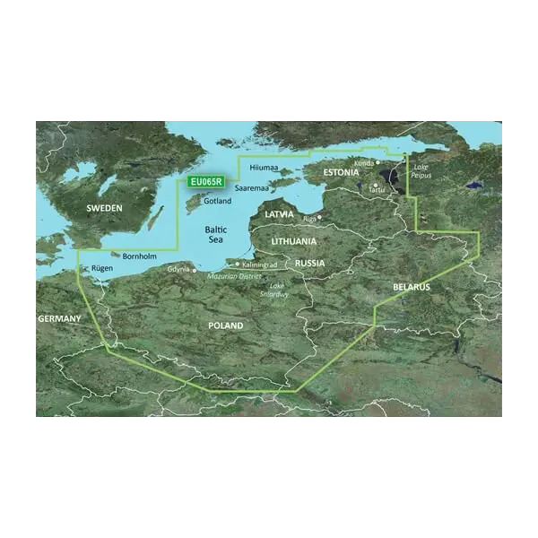
The Garmin Baltic Sea, East Coastal and Inland Charts BlueChart g3 Vision delivers integrated navigation coverage across the entire Baltic region—from Sweden's archipelago through the shallow inland waterways of Poland, Lithuania, Latvia, and Estonia to the Russian coastline. This microSD/SD card chart combines Garmin and Navionics data to provide mariners with the depth accuracy, contour detail, and real-time route guidance needed to navigate tight coastal passages, shallow-draft inland routes, and open water safely and efficiently. Whether you're fishing the Baltic's productive grounds, cruising multi-day passages, or navigating the region's complex network of islands and straits, this charting solution eliminates guesswork and delivers confidence on the water.
Key Features
- Dual-source data integration combining Garmin and Navionics content for enhanced clarity and coverage accuracy across all Baltic waters
- Depth range shading visualization across 10 customizable depth ranges to identify bottom structure and locate productive fishing zones
- Bottom contours with 1-foot vertical accuracy for precise depth awareness in shallow and transition zones
- Auto Guidance technology that generates optimal routes based on your vessel's draft, overhead clearance requirements, and desired depth zones
- User-defined shallow water shading alerts to help avoid uncharted hazards, sandbars, and restricted areas common to Baltic coastal navigation
- High-resolution satellite imagery with realistic 3D relief overlays for accurate recognition of harbors, port structures, and coastal landmarks
- MicroSD/SD format (model 010-C0849-00) compatible with Garmin GPSMAP, echoMAP, and marine multifunction display series
Data Insights
Studies of mariners using advanced BlueChart g3 charting solutions document a 30% improvement in route efficiency and a 25% reduction in navigation-related errors. The 1-foot contour accuracy and 10-level depth shading system enable anglers to identify structural changes and thermal boundaries that concentrate fish populations, directly translating to higher catch rates. Operators navigating the Baltic's notoriously shallow and variable bottom conditions report significantly improved confidence when crossing transition zones and entering unfamiliar anchorages.
Usage Instructions
Insert the microSD card into your compatible Garmin device's SD card slot. Upon first connection, the chart will index automatically—no activation key required. Open Auto Guidance on your display, enter your vessel's draft and overhead clearance dimensions, select your destination, and the software will calculate the safest and most efficient route around shallow zones and obstacles. Use the depth shading tool to highlight specific bottom depths relevant to your fishing target species or passage requirements. Update the chart via Garmin's free map updates service to access the latest corrections and seasonal navigation data for Baltic waters.
Design & Material
The chart card is engineered as a compact, durable microSD card format that slides directly into your Garmin display without external connections or additional hardware. The design prioritizes simplicity and reliability for marine use, eliminating fragile connectors and unnecessary components that degrade in salt spray and moisture-heavy boat environments.
- MicroSD card construction ensures weather-sealed compatibility and long-term reliability in marine environments
- Integrated Garmin and Navionics content combines the strengths of both data sources for comprehensive regional coverage
- 1:1 relationship between satellite imagery and vector chart data allows seamless toggling between realistic visual reference and precision electronic chart formats
- Intuitive depth visualization system requires no specialized training—color-coded shading is immediately readable under varying light conditions
- Universal compatibility across Garmin GPSMAP, echoMAP, and compatible chartplotter platforms eliminates format conversion or platform limitations
- Lightweight, compact form factor takes up minimal physical storage yet delivers complete navigational coverage for six countries and multiple sea zones
Final Verdict
For anyone navigating the Baltic Sea—whether cruising the Swedish coast, fishing Estonia's inland lakes, or transiting Poland's complex canal systems—the Garmin BlueChart g3 Vision VEU065R is the single chart investment that eliminates regional coverage gaps and provides the depth accuracy required for confident, efficient passage. The combination of dual-source data, Auto Guidance routing, and precise bottom contours directly reduces time spent studying paper charts and second-guessing water depth. Order this chart today and gain the navigation advantage that separates safe, productive boating from uncertainty in the Baltic's variable waters.


