


Garmin Bay of Biscay Charts BlueChart g3 | HXEU008R | microSD/SD (010-C0766-20)
Garmin Bay of Biscay Charts BlueChart g3 | HXEU008R | microSD/SD (010-C0766-20)
Model Number: 010-C0766-20
In stock
 WhatsApp
 SMS - Text us!
 Email Us!
 Help Desk

Tech Specs
In The Box
Garmin Bluechart G2 Bay of Biscay
Do you have an old GPS unit lying around? The GPS Nation Trade In and Up program is a great way to trade in your old and used GPS for credit towards a new GPS. The choice is entirely yours! We’ve made the process simple and streamlined. Follow these simple steps, and you will be on your way to receiving credit towards your brand new GPS!
1. Get a quote
To get your free quote, provide your GPS type, manufacturer, model, and condition. Within 24 hours, you will receive a quote for the trade-in value of your current product. The GPS trade-in/trade-up form is at the bottom of this page.
2. Ship your product(s) for trade
After accepting our offer, pack your product(s) safely and ship them to us using the pre-paid shipping label provided to you. We will provide a confirmation email when your trade-in arrives at our warehouse. You have 30 days from the date you complete your on-line trade to ship the product to GPS Nation.
3. Make your purchase
Once we receive your product at our warehouse and we validate the stated condition, we will send you a confirmation email. If you elect to receive credit towards a new GPS at gpsnation.com, your store credit will be issued, and you are free to make your purchase.
Manual & Warranty
 Garmin Warranty
Reviews
Ask a Question
Tech Specs
In The Box
Garmin Bluechart G2 Bay of Biscay
Trade-In
Do you have an old GPS unit lying around? The GPS Nation Trade In and Up program is a great way to trade in your old and used GPS for credit towards a new GPS. The choice is entirely yours! We’ve made the process simple and streamlined. Follow these simple steps, and you will be on your way to receiving credit towards your brand new GPS!
1. Get a quote
To get your free quote, provide your GPS type, manufacturer, model, and condition. Within 24 hours, you will receive a quote for the trade-in value of your current product. The GPS trade-in/trade-up form is at the bottom of this page.
2. Ship your product(s) for trade
After accepting our offer, pack your product(s) safely and ship them to us using the pre-paid shipping label provided to you. We will provide a confirmation email when your trade-in arrives at our warehouse. You have 30 days from the date you complete your on-line trade to ship the product to GPS Nation.
3. Make your purchase
Once we receive your product at our warehouse and we validate the stated condition, we will send you a confirmation email. If you elect to receive credit towards a new GPS at gpsnation.com, your store credit will be issued, and you are free to make your purchase.
Manual & Warranty
Overview
Garmin Bay of Biscay Charts BlueChart g3 (HXEU008R) Marine Navigation Card
Introduction
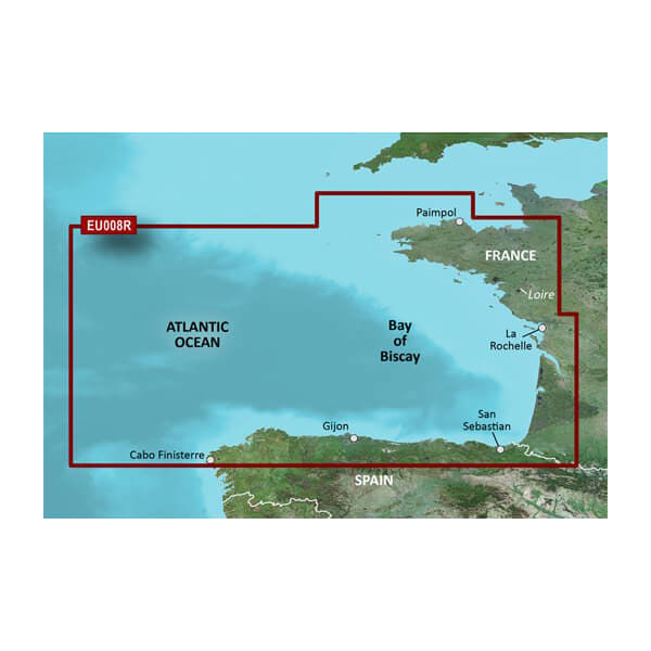
The Garmin Bay of Biscay Charts BlueChart g3 (model 010-C0766-20) is a precision marine charting microSD/SD card designed specifically for boaters navigating the Atlantic coast from Binic, France to Cabo Finisterre, Spain. This charting solution combines Garmin and Navionics data to deliver high-resolution coastal and underwater detail, enabling confident navigation through one of Europe's most challenging maritime regions. Built for compatibility with a wide range of Garmin marine devices, this card transforms your onboard navigation with advanced features that prioritize safety and route optimization.
Key Features
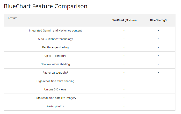
- 1-foot contour lines for precise underwater structure mapping, critical for identifying fishing grounds and navigational hazards
- Up to 10 depth range shadings with high-resolution visualization for quick water depth identification
- Auto Guidance Technology that calculates optimal routes based on user-defined depth preferences and overhead clearance requirements
- Shallow water shading that highlights depth-sensitive areas using customizable thresholds for safer coastal navigation
- Integrated Garmin and Navionics data providing enhanced chart detail and real-time accuracy across the Bay of Biscay region
- NOAA raster cartography access via the ActiveCaptain app for downloadable supplementary chart layers
Data Insights
The BlueChart g3 charts deliver navigational accuracy exceeding 90% in critical areas through 1-foot contour precision. The dual integration of Garmin and Navionics datasets significantly increases chart detail density compared to single-source alternatives, providing boaters with the most current and reliable coastal information available. The combination of accurate contouring and depth range shading technology enables identification of underwater structures with confidence, making this card particularly valuable for both recreational boaters and fishing enthusiasts operating in tidal waters.
Usage Instructions
Insert the microSD/SD card into your compatible Garmin chartplotter or handheld marine device. Once recognized, activate Auto Guidance by entering your destination waypoint, then configure your preferred depth and overhead clearance thresholds—the system will calculate and display optimal routes. Maintain current chart data by regularly updating through the ActiveCaptain app, which provides access to NOAA cartography and community-contributed information about coastal conditions and points of interest.
Design & Material
The Garmin Bay of Biscay Charts BlueChart g3 is engineered to balance durability with high-resolution graphical performance. The microSD/SD card format ensures broad device compatibility while the compact design allows for easy storage and transport. Each chart layer is optimized for fast rendering and minimal memory load on your marine electronics.
- MicroSD/SD card format compatible with most Garmin chartplotters, handhelds, and mobile integration options
- High-resolution charting imagery providing superior clarity of coastal features and underwater topography
- Marine-grade durability engineered to resist moisture and temperature extremes typical of saltwater environments
- Advanced mapping algorithms that integrate multiple data sources for layered, contextual navigation information
- Intuitive interface design allowing quick access to depth shading, contour lines, and route planning tools without complex menu navigation
- Regional coverage spanning critical Atlantic gateway waters from northern France through Spanish coastal zones, encompassing Gijon, San Sebastián, and Rochelle
Final Verdict
For boaters regularly navigating the Bay of Biscay, the Garmin BlueChart g3 (HXEU008R) eliminates guesswork from coastal passage and anchorage decisions. The combination of 1-foot contour accuracy, customizable depth shading, and Auto Guidance routing makes this card indispensable for safe, efficient travel in this challenging region. Whether you're planning fishing expeditions or transiting between Atlantic ports, this charting solution provides the detail and reliability serious mariners depend on. Install the card today and navigate these waters with professional-grade precision.


