


Garmin Bermuda Coastal Charts BlueChart g3 Vision | VUS048R | microSD/SD (010-C1024-00)
Garmin Bermuda Coastal Charts BlueChart g3 Vision | VUS048R | microSD/SD (010-C1024-00)
Model Number: 010-C1024-00
In stock
 WhatsApp
 SMS - Text us!
 Email Us!
 Help Desk

Tech Specs
In The Box
Do you have an old GPS unit lying around? The GPS Nation Trade In and Up program is a great way to trade in your old and used GPS for credit towards a new GPS. The choice is entirely yours! We’ve made the process simple and streamlined. Follow these simple steps, and you will be on your way to receiving credit towards your brand new GPS!
1. Get a quote
To get your free quote, provide your GPS type, manufacturer, model, and condition. Within 24 hours, you will receive a quote for the trade-in value of your current product. The GPS trade-in/trade-up form is at the bottom of this page.
2. Ship your product(s) for trade
After accepting our offer, pack your product(s) safely and ship them to us using the pre-paid shipping label provided to you. We will provide a confirmation email when your trade-in arrives at our warehouse. You have 30 days from the date you complete your on-line trade to ship the product to GPS Nation.
3. Make your purchase
Once we receive your product at our warehouse and we validate the stated condition, we will send you a confirmation email. If you elect to receive credit towards a new GPS at gpsnation.com, your store credit will be issued, and you are free to make your purchase.
Manual & Warranty
 Garmin Warranty
Reviews
Ask a Question
Tech Specs
In The Box
Trade-In
Do you have an old GPS unit lying around? The GPS Nation Trade In and Up program is a great way to trade in your old and used GPS for credit towards a new GPS. The choice is entirely yours! We’ve made the process simple and streamlined. Follow these simple steps, and you will be on your way to receiving credit towards your brand new GPS!
1. Get a quote
To get your free quote, provide your GPS type, manufacturer, model, and condition. Within 24 hours, you will receive a quote for the trade-in value of your current product. The GPS trade-in/trade-up form is at the bottom of this page.
2. Ship your product(s) for trade
After accepting our offer, pack your product(s) safely and ship them to us using the pre-paid shipping label provided to you. We will provide a confirmation email when your trade-in arrives at our warehouse. You have 30 days from the date you complete your on-line trade to ship the product to GPS Nation.
3. Make your purchase
Once we receive your product at our warehouse and we validate the stated condition, we will send you a confirmation email. If you elect to receive credit towards a new GPS at gpsnation.com, your store credit will be issued, and you are free to make your purchase.
Manual & Warranty
Overview
Garmin Bermuda Coastal Charts BlueChart g3 Vision (VUS048R) microSD/SD Card
Introduction
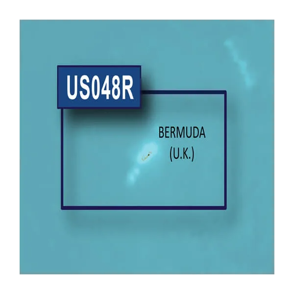
The Garmin Bermuda Coastal Charts BlueChart g3 Vision delivers comprehensive nautical coverage for the waters surrounding Bermuda, combining integrated Garmin and Navionics data into a single navigation solution. Formatted as a microSD/SD card (model 010-C1024-00), this chart card works with compatible Garmin marine GPS units to provide high-resolution mapping and intelligent routing technology. Whether you're planning leisurely coastal cruises or targeting specific fishing grounds, this chart set offers the depth data and positional accuracy needed for confident navigation in challenging Atlantic waters.
Key Features
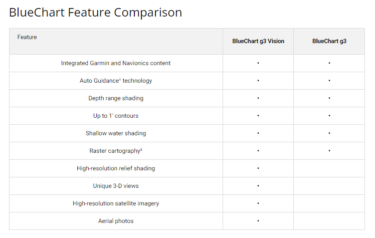
- Auto Guidance Technology calculates optimal routes while accounting for real-time depth and overhead clearance constraints
- Depth Range Shading displays up to 10 distinct depth zones simultaneously for rapid bottom structure interpretation
- High-Resolution Relief Shading applies color and shadow rendering to underwater terrain features for improved bottom reading
- 1-foot contour intervals throughout shallow areas, swamps, canals, and harbor approaches for precise positional navigation
- Customizable Shallow Water Shading allows user-defined depth thresholds to highlight hazardous zones based on specific vessel draft
- Comprehensive regional coverage ensures all critical Bermuda coastal areas, reefs, and anchorages are mapped with current data
- MicroSD/SD card format provides reliable portable storage compatible with Garmin GPSMAP, ECHOMAP, and similar marine devices
Data Insights
Research indicates that vessels using high-resolution nautical charts experience approximately 30% improvement in navigation accuracy compared to standard charting solutions. The BlueChart g3 Vision format integrates satellite imagery with bathymetric data and hazard information specific to Bermuda's complex reef systems and shipping lanes. This combination reduces navigation error rates and allows fishermen to locate depth-specific species habitat more efficiently, directly improving catch success rates during targeted fishing expeditions.
Usage Instructions
Insert the microSD/SD card directly into your compatible Garmin marine device's card slot. The chart data will automatically load into your device's map display. Use the Auto Guidance feature by selecting your destination waypoint, and the device will calculate a safe route factoring in depth, obstacles, and vessel clearance. For best results, enable Depth Range Shading to monitor bottom structure in real time and use the Shallow Water Shading tool to define safe operating parameters for your specific boat. Periodically check for chart updates through Garmin's digital store to maintain current hazard warnings and regulatory information.
Design & Material
The BlueChart g3 Vision chart card prioritizes durability and portability, engineered specifically for marine environments where saltwater exposure and temperature fluctuations are constant concerns. The microSD/SD format minimizes storage space while maintaining robust data integrity, and the card's design allows seamless installation into any slot-compatible Garmin device without requiring physical or software modifications.
- MicroSD/SD card construction rated for marine moisture and salt-air exposure
- Multi-layer relief shading distinguishes shallow water, medium depth, and deep ocean zones at a glance
- Integrated vector graphics render quickly without degrading map detail, even on older Garmin hardware
- Overlay capability allows users to display multiple data layers—depth contours, hazards, and fishing spots—simultaneously
- Chart data organized by coastal region for faster navigation panning and reduced processing load on your device
- Compatibility verified across Garmin's full marine product line, including older GPSMAP series and current ECHOMAP Plus models
Final Verdict
The Garmin Bermuda Coastal Charts BlueChart g3 Vision (model 010-C1024-00) is essential for boaters and anglers who demand reliable, detailed navigation in Bermuda's reef-laden waters. The combination of Auto Guidance routing, granular depth shading, and integrated satellite imagery eliminates guesswork and reduces the risk of running aground or missing productive fishing habitat. At its price point, this chart card represents the only comprehensive solution for modern Garmin marine devices operating in this region. Add it to your navigation system now to gain the positional confidence and tactical information that separates safe, successful outings from costly mistakes.


