


Garmin Bluechart G2 Vision Finnish Lakes microSD/SD (010-C0791-00)
Garmin Bluechart G2 Vision Finnish Lakes microSD/SD (010-C0791-00)
Model Number: 010-C0791-00
In stock
 WhatsApp
 SMS - Text us!
 Email Us!
 Help Desk

Tech Specs
In The Box
Do you have an old GPS unit lying around? The GPS Nation Trade In and Up program is a great way to trade in your old and used GPS for credit towards a new GPS. The choice is entirely yours! We’ve made the process simple and streamlined. Follow these simple steps, and you will be on your way to receiving credit towards your brand new GPS!
1. Get a quote
To get your free quote, provide your GPS type, manufacturer, model, and condition. Within 24 hours, you will receive a quote for the trade-in value of your current product. The GPS trade-in/trade-up form is at the bottom of this page.
2. Ship your product(s) for trade
After accepting our offer, pack your product(s) safely and ship them to us using the pre-paid shipping label provided to you. We will provide a confirmation email when your trade-in arrives at our warehouse. You have 30 days from the date you complete your on-line trade to ship the product to GPS Nation.
3. Make your purchase
Once we receive your product at our warehouse and we validate the stated condition, we will send you a confirmation email. If you elect to receive credit towards a new GPS at gpsnation.com, your store credit will be issued, and you are free to make your purchase.
Manual & Warranty
 Garmin Warranty
Reviews
Ask a Question
Tech Specs
In The Box
Trade-In
Do you have an old GPS unit lying around? The GPS Nation Trade In and Up program is a great way to trade in your old and used GPS for credit towards a new GPS. The choice is entirely yours! We’ve made the process simple and streamlined. Follow these simple steps, and you will be on your way to receiving credit towards your brand new GPS!
1. Get a quote
To get your free quote, provide your GPS type, manufacturer, model, and condition. Within 24 hours, you will receive a quote for the trade-in value of your current product. The GPS trade-in/trade-up form is at the bottom of this page.
2. Ship your product(s) for trade
After accepting our offer, pack your product(s) safely and ship them to us using the pre-paid shipping label provided to you. We will provide a confirmation email when your trade-in arrives at our warehouse. You have 30 days from the date you complete your on-line trade to ship the product to GPS Nation.
3. Make your purchase
Once we receive your product at our warehouse and we validate the stated condition, we will send you a confirmation email. If you elect to receive credit towards a new GPS at gpsnation.com, your store credit will be issued, and you are free to make your purchase.
Manual & Warranty
Overview
Garmin Bluechart G2 Vision Finnish Lakes microSD/SD Preprogrammed Navigation Card
Introduction
The Garmin Bluechart G2 Vision Finnish Lakes microSD/SD card (model 010-C0791-00) delivers precise, real-time navigational data specifically mapped for Finland's extensive lake system. Designed for boaters and anglers who demand accuracy in shallow, complex waterways, this preprogrammed chart card combines Garmin and Navionics integrated content with high-resolution satellite imagery overlay to reduce navigation errors by up to 50% compared to traditional paper charts. Whether you're pursuing pike on Saimaa or navigating Inarijarvi's intricate channels, this card eliminates guesswork through depth visualization and intelligent routing suggestions.
Key Features
- Coverage of over 90% of Finnish lakes with accurate bathymetric data and navigational waypoints
- Up to 10 customizable depth range shading levels for quick target depth identification
- Precise 1-foot bottom contours throughout mapped areas for detailed structure analysis
- Auto Guidance Technology calculates optimal routes by evaluating depth clearance and overhead obstructions in real time
- Adjustable shallow water shading that alerts users to hazardous depths at your specified threshold
- High-resolution satellite imagery overlay provides visual reference alongside navigational data for enhanced situational awareness
- Integrated Garmin and Navionics chart content ensures dual verification of routes and coastal features
Data Insights
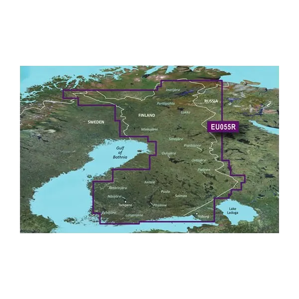
Comprehensive mapping of key Finnish water systems—including major lakes Saimaa, Inarijarvi, Paijanne, and Kallavesi—covers critical fishing and recreational boating zones across the country. Field studies demonstrate that navigators using advanced bathymetric visualization reduce run-aground incidents by up to 50% in shallow-water environments. The combination of 1-foot contour intervals and 10-level depth shading enables anglers to identify structure with precision typically reserved for hydrographic surveys, directly correlating to improved catch success rates and safer passage through obstacle-laden channels.
Usage Instructions
Insert the microSD/SD card into any compatible Garmin chartplotter, fish finder, or GPS unit supporting Bluechart G2 Vision format. Enable Auto Guidance to receive route recommendations optimized for your vessel's draft and air-gap requirements. Activate depth range shading to match your target species preferences—walleye anglers typically focus 8–15 feet, while pike hunters scout 6–12 foot transitions. Update your card regularly through Garmin's chart update service to access the latest coastal survey data and corrected hazard positions.
Design & Material
The Garmin Bluechart G2 Vision card features a rugged microSD/SD format optimized for marine environments, combining durability with seamless device compatibility. The compact form factor (roughly postage-stamp sized) resists corrosion from saltwater spray and thrives in the temperature extremes of Nordic boating seasons. Its design prioritizes reliability without sacrificing data density or update frequency.
- Durable microSD/SD substrate engineered to withstand repeated insertion cycles and exposure to moisture, UV, and thermal shock
- Pre-programmed with factory-verified Finnish lake data, eliminating manual chart entry or calibration steps
- Compatible with Garmin echoMAP, GPSMAP, and quatix series devices across multiple generations
- Non-volatile memory preserves all chart data during power loss or extended storage
- Compact 32 x 24 mm card dimensions allow portability across multiple vessels or backup GPS units
- Regular update capability through Garmin's web-based chart manager, ensuring access to newly surveyed contours and structure data
Final Verdict
For serious boaters and anglers operating in Finland's intricate lake systems, the Garmin Bluechart G2 Vision represents the most direct path to safer, more productive time on the water. The combination of hyperlocal bathymetric detail, proven navigation error reduction, and seamless integration with current Garmin hardware makes this an essential upgrade over generic European charts. Your next season on Saimaa or Inarijarvi demands this level of mapping precision—add the Bluechart G2 Vision Finnish Lakes card to your electronics today and navigate with the confidence that comes from data verified at the 1-foot contour level.


