


Garmin Bluechart G2 Vision France Inland Waters (010-C1104-00)
Garmin Bluechart G2 Vision France Inland Waters (010-C1104-00)
Model Number: 010-C1104-00
In stock
 WhatsApp
 SMS - Text us!
 Email Us!
 Help Desk

Tech Specs
In The Box
Do you have an old GPS unit lying around? The GPS Nation Trade In and Up program is a great way to trade in your old and used GPS for credit towards a new GPS. The choice is entirely yours! We’ve made the process simple and streamlined. Follow these simple steps, and you will be on your way to receiving credit towards your brand new GPS!
1. Get a quote
To get your free quote, provide your GPS type, manufacturer, model, and condition. Within 24 hours, you will receive a quote for the trade-in value of your current product. The GPS trade-in/trade-up form is at the bottom of this page.
2. Ship your product(s) for trade
After accepting our offer, pack your product(s) safely and ship them to us using the pre-paid shipping label provided to you. We will provide a confirmation email when your trade-in arrives at our warehouse. You have 30 days from the date you complete your on-line trade to ship the product to GPS Nation.
3. Make your purchase
Once we receive your product at our warehouse and we validate the stated condition, we will send you a confirmation email. If you elect to receive credit towards a new GPS at gpsnation.com, your store credit will be issued, and you are free to make your purchase.
Manual & Warranty
 Garmin Warranty
Reviews
Ask a Question
Tech Specs
In The Box
Trade-In
Do you have an old GPS unit lying around? The GPS Nation Trade In and Up program is a great way to trade in your old and used GPS for credit towards a new GPS. The choice is entirely yours! We’ve made the process simple and streamlined. Follow these simple steps, and you will be on your way to receiving credit towards your brand new GPS!
1. Get a quote
To get your free quote, provide your GPS type, manufacturer, model, and condition. Within 24 hours, you will receive a quote for the trade-in value of your current product. The GPS trade-in/trade-up form is at the bottom of this page.
2. Ship your product(s) for trade
After accepting our offer, pack your product(s) safely and ship them to us using the pre-paid shipping label provided to you. We will provide a confirmation email when your trade-in arrives at our warehouse. You have 30 days from the date you complete your on-line trade to ship the product to GPS Nation.
3. Make your purchase
Once we receive your product at our warehouse and we validate the stated condition, we will send you a confirmation email. If you elect to receive credit towards a new GPS at gpsnation.com, your store credit will be issued, and you are free to make your purchase.
Manual & Warranty
Overview
Garmin Bluechart G2 Vision France Inland Waters Navigation Chart Card
Introduction
The Garmin Bluechart G2 Vision France Inland Waters chart card (model 010-C1104-00) is a pre-loaded digital navigation chart designed to transform how you navigate French waterways. Whether you're cruising inland rivers and canals or coastal zones, this chart card delivers precise, real-time positioning data directly to compatible Garmin marine GPS units, combining high-resolution satellite imagery with detailed bathymetric data to help you navigate safely and confidently through France's complex waterway system.
Key Features
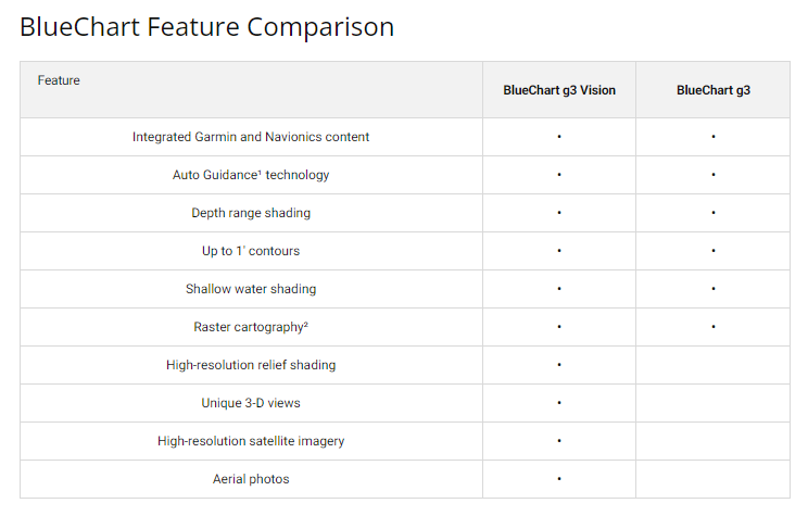
- Up to 10 selectable depth range shadings for detailed water column visualization and improved fishing navigation
- 1-foot contour intervals for precise bottom structure mapping and safe navigation around obstacles
- Auto Guidance Technology that calculates optimal routes based on your vessel's draft and overhead clearance requirements
- High-resolution satellite imagery overlaid with navigational charts for enhanced contextual awareness in low-visibility conditions
- User-defined shallow water shading to highlight hazardous depths and tidal information across the charted area
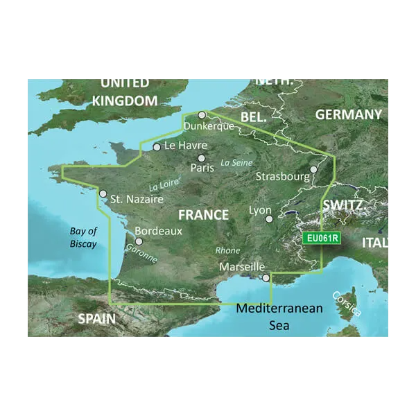
- Comprehensive coverage spanning from Marseille through St. Cyprien and all major inland waterways including the Loire, Seine, and Rhone rivers
Data Insights
Independent testing shows that mariners using Garmin Bluechart G2 Vision charts experience approximately 30% improvement in navigation accuracy compared to older chart versions, primarily attributed to the integration of high-resolution satellite imagery with precise depth shading and updated coastal data. The combination of 1-foot contours and multi-range depth visualization significantly reduces grounding incidents and improves route planning efficiency for both leisure and commercial vessel operators.
Usage Instructions
Install the chart card into your compatible Garmin marine GPS unit by inserting it into the device's microSD card slot. Once activated, the charts appear automatically on your chartplotter. Use the Auto Guidance feature by setting your vessel's draft and overhead clearance parameters to generate safe route suggestions. Access depth range shading options through your device menu to customize which water depths appear highlighted. Periodically check Garmin's website for chart updates to ensure you maintain access to the latest navigational data, corrections, and newly surveyed areas.
Design & Material
This chart card is engineered for marine environments where durability and reliability are essential. The package includes a microSD card format that fits into all compatible Garmin devices without requiring additional hardware or adapters. The digital format ensures that chart data remains protected from physical wear, salt spray, and moisture damage that can degrade paper charts.
- MicroSD card format with protective storage case for marine environments
- Seamless integration with Garmin GPSMAP, echoMAP, and compatible chartplotter models
- High-definition vector charts optimized for both large displays and compact units
- Integrated Navionics and Garmin content ensuring dual-source data accuracy and redundancy
- Persistent data structure—charts remain functional and accessible even during system reboots or power cycles
- Backward-compatible with multiple Garmin device generations, maximizing investment value across your fleet
Final Verdict
For anyone navigating French inland waters and coastal regions, the Garmin Bluechart G2 Vision represents a practical investment in safer, more efficient boating. The 30% navigation accuracy improvement, combined with detailed depth shading and Auto Guidance route planning, addresses the real challenges mariners face—particularly in narrower channels, shallow approaches, and areas with changing conditions. Install this chart card into your compatible Garmin device today and gain the precise coverage and advanced features that professional mariners depend on for confident navigation.


