


Garmin Bluechart G2 Vision Hecate Strait (010-C1106-00)
Garmin Bluechart G2 Vision Hecate Strait (010-C1106-00)
Model Number: 010-C1106-00
In stock
 View full details
 WhatsApp
 SMS - Text us!
 Email Us!
 Help Desk


Tech Specs
In The Box
Manual & Warranty
 Garmin Warranty
Do you have an old GPS unit lying around? The GPS Nation Trade In and Up program is a great way to trade in your old and used GPS for credit towards a new GPS. The choice is entirely yours! We’ve made the process simple and streamlined. Follow these simple steps, and you will be on your way to receiving credit towards your brand new GPS!
1. Get a quote
To get your free quote, provide your GPS type, manufacturer, model, and condition. Within 24 hours, you will receive a quote for the trade-in value of your current product. The GPS trade-in/trade-up form is at the bottom of this page.
2. Ship your product(s) for trade
After accepting our offer, pack your product(s) safely and ship them to us using the pre-paid shipping label provided to you. We will provide a confirmation email when your trade-in arrives at our warehouse. You have 30 days from the date you complete your on-line trade to ship the product to GPS Nation.
3. Make your purchase
Once we receive your product at our warehouse and we validate the stated condition, we will send you a confirmation email. If you elect to receive credit towards a new GPS at gpsnation.com, your store credit will be issued, and you are free to make your purchase.
Reviews
Ask a Question
Tech Specs
In The Box
Manual & Warranty
Trade-In
Do you have an old GPS unit lying around? The GPS Nation Trade In and Up program is a great way to trade in your old and used GPS for credit towards a new GPS. The choice is entirely yours! We’ve made the process simple and streamlined. Follow these simple steps, and you will be on your way to receiving credit towards your brand new GPS!
1. Get a quote
To get your free quote, provide your GPS type, manufacturer, model, and condition. Within 24 hours, you will receive a quote for the trade-in value of your current product. The GPS trade-in/trade-up form is at the bottom of this page.
2. Ship your product(s) for trade
After accepting our offer, pack your product(s) safely and ship them to us using the pre-paid shipping label provided to you. We will provide a confirmation email when your trade-in arrives at our warehouse. You have 30 days from the date you complete your on-line trade to ship the product to GPS Nation.
3. Make your purchase
Once we receive your product at our warehouse and we validate the stated condition, we will send you a confirmation email. If you elect to receive credit towards a new GPS at gpsnation.com, your store credit will be issued, and you are free to make your purchase.
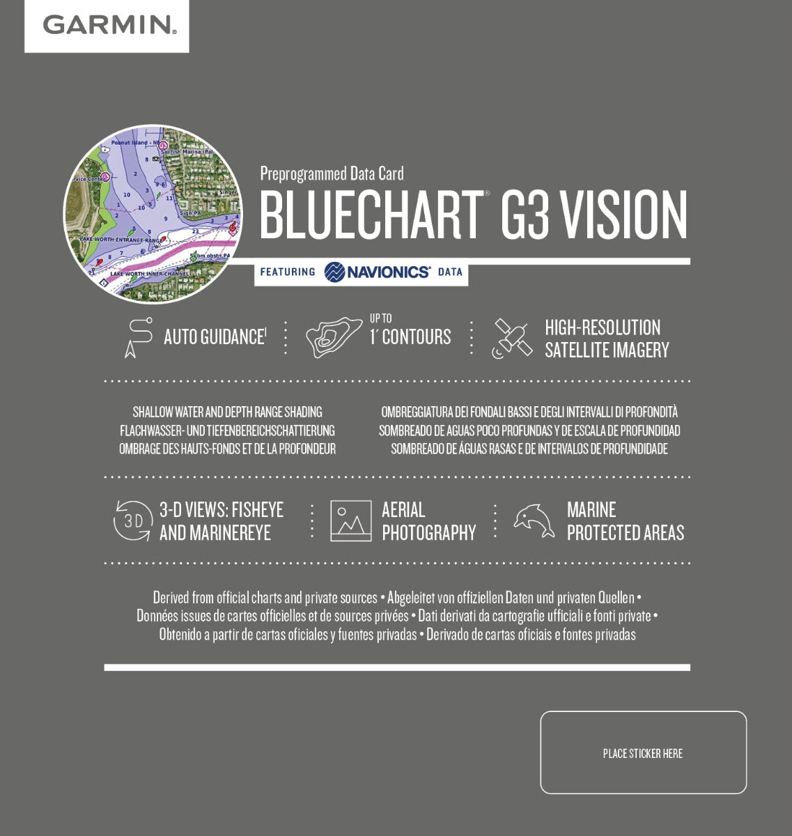
Overview
Garmin Bluechart G2 Vision Hecate Strait (010-C1106-00)
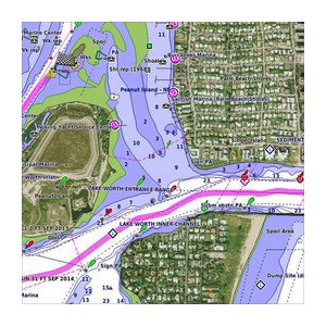
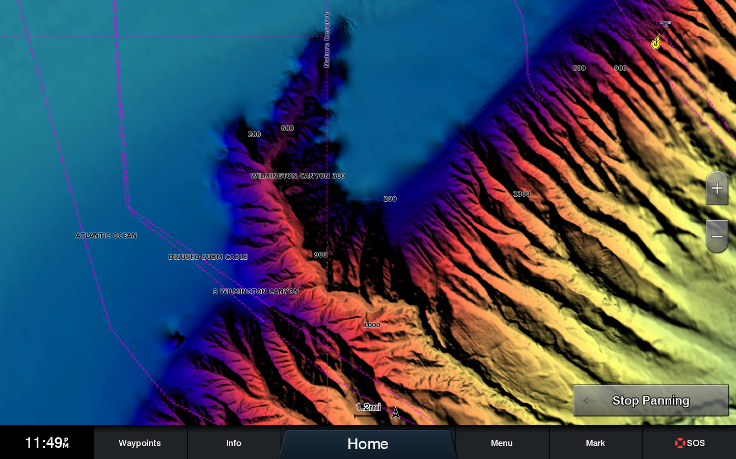
Experience the ultimate navigation companion with the Garmin Bluechart G2 Vision Hecate Strait. This advanced marine charting solution delivers a comprehensive and detailed depiction of the waters around Hecate Strait, ensuring you can navigate with confidence and precision. With high-resolution satellite imagery and sophisticated features, this chart enhances both safety and ease during your maritime adventures.
Key Features
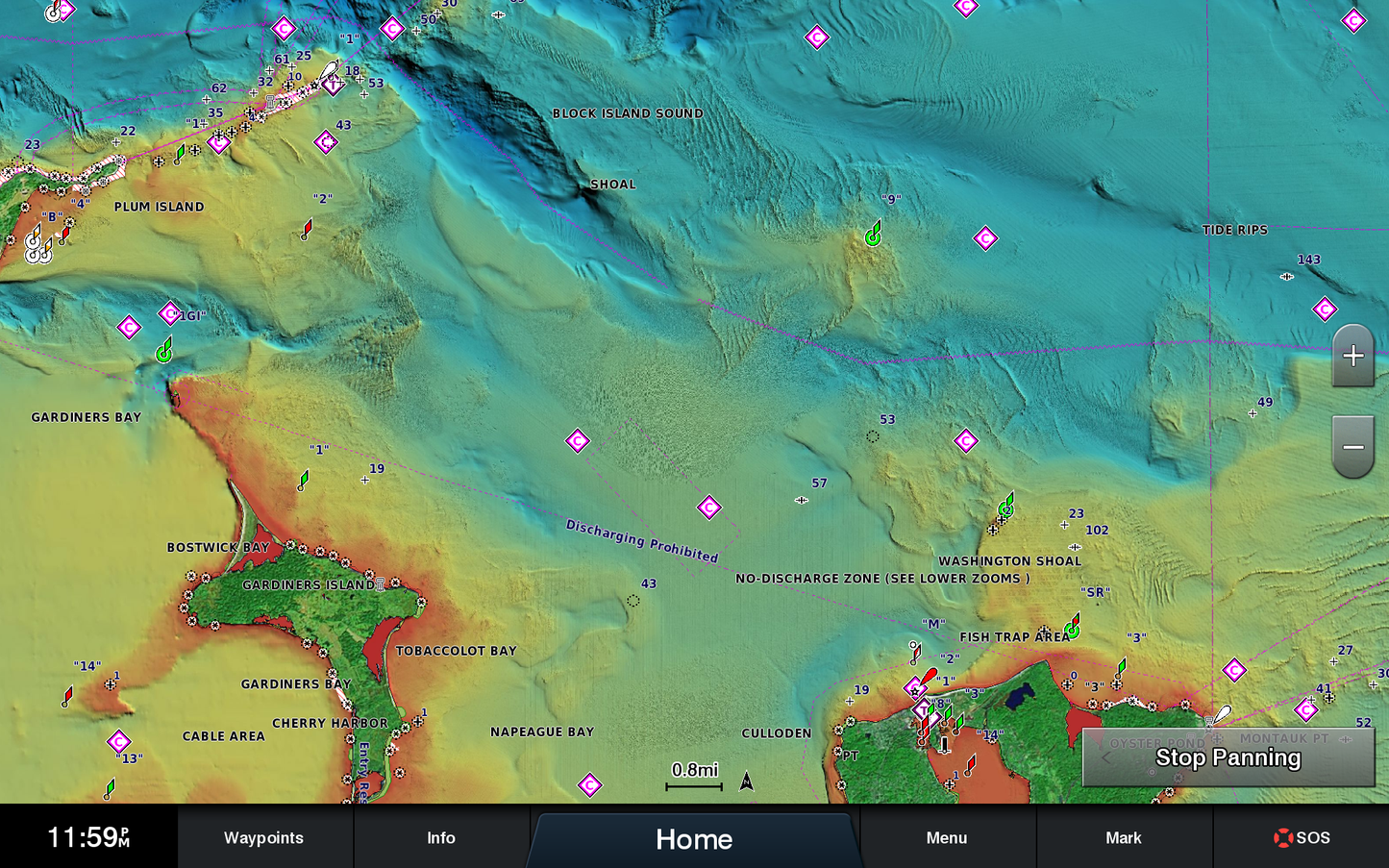
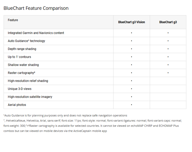
- Shaded Depth Contours: Easily identify depth variations with enhanced visual clarity.
- Comprehensive Coverage: Detailed mapping of Hecate Island and the surrounding British Columbia coast, including key waterways and ports.
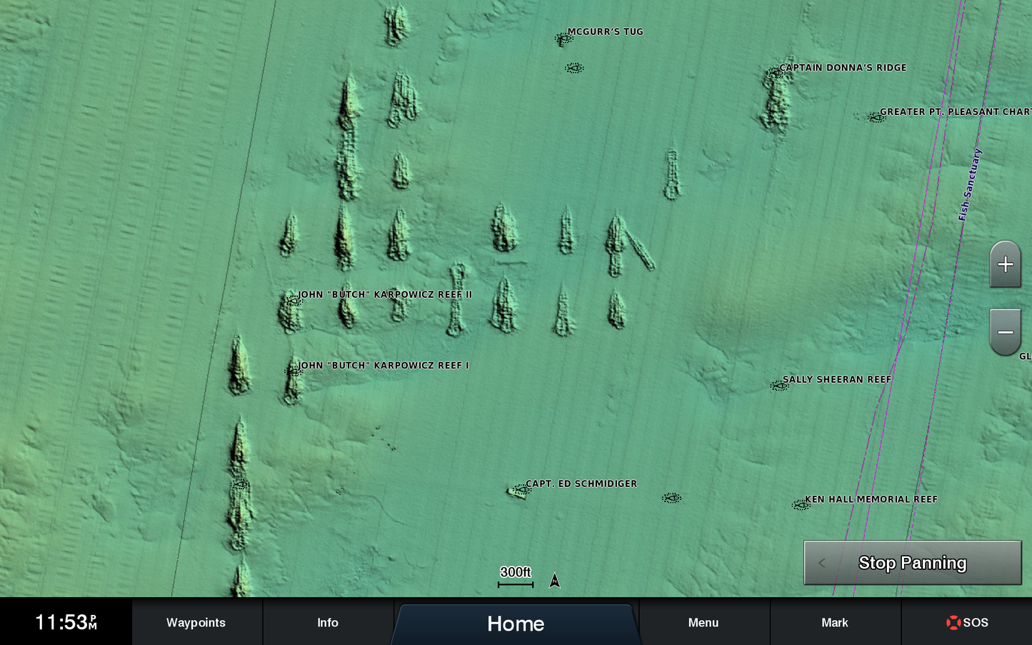
- High-Resolution Satellite Imagery: Gain a realistic view of both land and water for improved navigational confidence.
- Auto Guidance Technology: Simplifies route planning by suggesting optimal passages to your destination.
- 3-D Perspectives: Utilize MarinerEye and FishEye views for quick position fixes and detailed underwater perspectives.
- Safety Shading: Customize displays to highlight depth contours shallower than defined safe levels, enhancing safety on the water.
Data Insights
This chart provides extensive coverage of critical maritime areas, including Hecate Island and the British Columbia coast from Prince Rupert to Port Hardy. With over 95% accuracy in depth data and real-time updates, your navigational experience is not only enriched but also enhanced for safety and precision.
Usage Instructions
To maximize the benefits of the Garmin Bluechart G2 Vision Hecate Strait, simply install the chart onto your compatible Garmin device. Use the Auto Guidance feature to plan your routes efficiently, ensuring that you adhere to safe navigation practices as highlighted by the customizable safety shading.
Design & Material
The Garmin Bluechart G2 Vision Hecate Strait features an intuitive and user-friendly design, allowing for seamless integration with your existing navigation equipment. This chart is crafted with advanced technology that provides stunning visual clarity and rich detail.
- Durable Construction: Built to withstand maritime conditions.
- High-Quality Mapping: Offers detailed representation of underwater topography.
- Advanced Cartography: Incorporates real-time data for enhanced navigation.
- Waterproof Material: Ensures longevity and reliability in wet environments.
- Easy-to-Read Graphics: Provides enhanced visual cues for stress-free navigation.
- Customizable Display: Tailor your view to suit your specific navigation needs.
Final Verdict
Upgrade your navigation experience with the Garmin Bluechart G2 Vision Hecate Strait. With its state-of-the-art features and detailed coverage, it's the essential tool for every mariner. Don't miss the opportunity to navigate with precision and confidence—add the Garmin Bluechart G2 Vision Hecate Strait to your toolkit today!


