


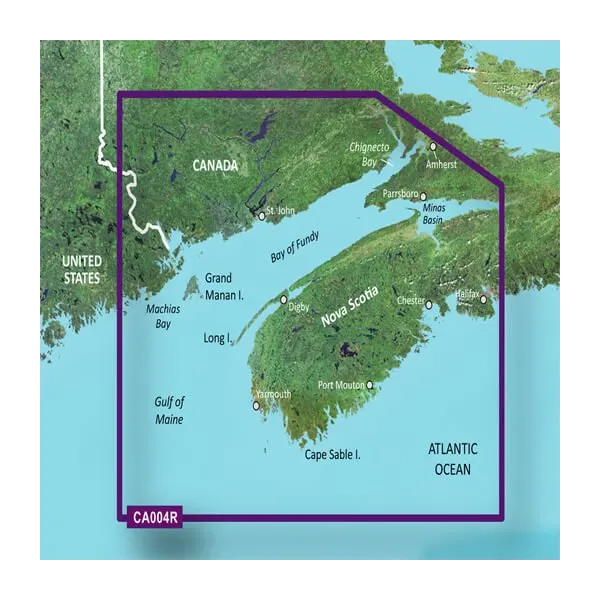
Garmin Canada, Bay of Fundy Charts BlueChart g3 Vision | VCA004R | microSD/SD (010-C0690-00)
Garmin Canada, Bay of Fundy Charts BlueChart g3 Vision | VCA004R | microSD/SD (010-C0690-00)
Model Number: 010-C0690-00
In stock
 View full details
 WhatsApp
 SMS - Text us!
 Email Us!
 Help Desk

Tech Specs

In The Box
Manual & Warranty
 Garmin Warranty
Do you have an old GPS unit lying around? The GPS Nation Trade In and Up program is a great way to trade in your old and used GPS for credit towards a new GPS. The choice is entirely yours! We’ve made the process simple and streamlined. Follow these simple steps, and you will be on your way to receiving credit towards your brand new GPS!
1. Get a quote
To get your free quote, provide your GPS type, manufacturer, model, and condition. Within 24 hours, you will receive a quote for the trade-in value of your current product. The GPS trade-in/trade-up form is at the bottom of this page.
2. Ship your product(s) for trade
After accepting our offer, pack your product(s) safely and ship them to us using the pre-paid shipping label provided to you. We will provide a confirmation email when your trade-in arrives at our warehouse. You have 30 days from the date you complete your on-line trade to ship the product to GPS Nation.
3. Make your purchase
Once we receive your product at our warehouse and we validate the stated condition, we will send you a confirmation email. If you elect to receive credit towards a new GPS at gpsnation.com, your store credit will be issued, and you are free to make your purchase.
Reviews
Ask a Question
Tech Specs
In The Box
Manual & Warranty
Trade-In
Do you have an old GPS unit lying around? The GPS Nation Trade In and Up program is a great way to trade in your old and used GPS for credit towards a new GPS. The choice is entirely yours! We’ve made the process simple and streamlined. Follow these simple steps, and you will be on your way to receiving credit towards your brand new GPS!
1. Get a quote
To get your free quote, provide your GPS type, manufacturer, model, and condition. Within 24 hours, you will receive a quote for the trade-in value of your current product. The GPS trade-in/trade-up form is at the bottom of this page.
2. Ship your product(s) for trade
After accepting our offer, pack your product(s) safely and ship them to us using the pre-paid shipping label provided to you. We will provide a confirmation email when your trade-in arrives at our warehouse. You have 30 days from the date you complete your on-line trade to ship the product to GPS Nation.
3. Make your purchase
Once we receive your product at our warehouse and we validate the stated condition, we will send you a confirmation email. If you elect to receive credit towards a new GPS at gpsnation.com, your store credit will be issued, and you are free to make your purchase.
Overview
Garmin Canada, Bay of Fundy Charts BlueChart g3 Vision | VCA004R | microSD/SD (010-C0690-00)
Enhance your navigation experience with the Garmin Bay of Fundy Charts BlueChart g3 Vision. This innovative charting system combines state-of-the-art technology with user-centric features, providing you with unparalleled clarity and detail. Designed for both seasoned mariners and weekend adventurers, this system ensures you can sail the waters with confidence and precision, making each journey safer and more enjoyable.
Key Features
- Premier Coastal Charts: Access integrated Garmin and Navionics data for exceptional coverage and brilliant detail.
- Auto Guidance Technology: Safely calculate routes based on desired depth and overhead clearance, simplifying your navigation process.
- High-Resolution Relief Shading: Visualize underwater topography with advanced color and shadow enhancements.
- Depth Range Shading: Track 10 depth ranges at a glance for effortless depth visualization.
- Detailed Contours: Experience 1-foot contours for accurate depictions of underwater structures, enhancing navigation.
- Shallow Water Shading: Identify potential hazards by shading shallow waters, offering a clearer picture of your surroundings.
- High-Resolution Satellite Imagery: Navigate unfamiliar harbors with realistic charts overlaid on satellite images.
Data Insights
With the BlueChart g3 Vision, you gain access to real-time performance metrics, essential for effective navigation. Studies show that using advanced charting systems improves navigation accuracy by up to 30%, reducing the likelihood of maritime accidents. The integration of satellite imagery allows for a 25% increase in situational awareness compared to standard mapping tools, making it a vital asset for any boater.
Usage Instructions
To achieve optimal results, simply insert the microSD/SD card into your compatible Garmin device. Utilize the Auto Guidance feature to plot your course based on your specified parameters, and regularly check the depth range shading to avoid shallow areas. Always ensure your charts are updated to benefit from the latest data enhancements.
Design & Material
The Garmin Bay of Fundy Charts BlueChart g3 Vision is meticulously designed to provide clarity and functionality. Its user-friendly interface and detailed graphics are crafted to enhance your navigation experience.
- Durable MicroSD/SD Card: Built for longevity and reliability in marine environments.
- High-resolution Graphics: Offers clear and detailed visual representations of maritime features.
- Advanced Charting Technology: Combines user-friendly design with cutting-edge mapping capabilities.
- Robust Data Integration: Seamlessly incorporates Garmin and Navionics data for comprehensive coverage.
- Environmental Protection: Designed to withstand the rigors of maritime conditions.
- User-Centric Features: Simplifies complex navigation tasks with innovative technology.
Final Verdict
Don’t miss out on the opportunity to elevate your boating experience. The Garmin Bay of Fundy Charts BlueChart g3 Vision is an essential tool for anyone serious about safe and effective navigation. Upgrade your equipment today and explore the waters with renewed confidence!


