


Garmin Caspian Sea, Volga River to Ulyanovsk and Orsk Charts BlueChart g3 | HXEU069R | microSD/SD (010-C1211-20)
Garmin Caspian Sea, Volga River to Ulyanovsk and Orsk Charts BlueChart g3 | HXEU069R | microSD/SD (010-C1211-20)
Model Number: 010-C1211-20
In stock
 WhatsApp
 SMS - Text us!
 Email Us!
 Help Desk

Tech Specs
In The Box
Do you have an old GPS unit lying around? The GPS Nation Trade In and Up program is a great way to trade in your old and used GPS for credit towards a new GPS. The choice is entirely yours! We’ve made the process simple and streamlined. Follow these simple steps, and you will be on your way to receiving credit towards your brand new GPS!
1. Get a quote
To get your free quote, provide your GPS type, manufacturer, model, and condition. Within 24 hours, you will receive a quote for the trade-in value of your current product. The GPS trade-in/trade-up form is at the bottom of this page.
2. Ship your product(s) for trade
After accepting our offer, pack your product(s) safely and ship them to us using the pre-paid shipping label provided to you. We will provide a confirmation email when your trade-in arrives at our warehouse. You have 30 days from the date you complete your on-line trade to ship the product to GPS Nation.
3. Make your purchase
Once we receive your product at our warehouse and we validate the stated condition, we will send you a confirmation email. If you elect to receive credit towards a new GPS at gpsnation.com, your store credit will be issued, and you are free to make your purchase.
Manual & Warranty
 Garmin Warranty
Reviews
Ask a Question
Tech Specs
In The Box
Trade-In
Do you have an old GPS unit lying around? The GPS Nation Trade In and Up program is a great way to trade in your old and used GPS for credit towards a new GPS. The choice is entirely yours! We’ve made the process simple and streamlined. Follow these simple steps, and you will be on your way to receiving credit towards your brand new GPS!
1. Get a quote
To get your free quote, provide your GPS type, manufacturer, model, and condition. Within 24 hours, you will receive a quote for the trade-in value of your current product. The GPS trade-in/trade-up form is at the bottom of this page.
2. Ship your product(s) for trade
After accepting our offer, pack your product(s) safely and ship them to us using the pre-paid shipping label provided to you. We will provide a confirmation email when your trade-in arrives at our warehouse. You have 30 days from the date you complete your on-line trade to ship the product to GPS Nation.
3. Make your purchase
Once we receive your product at our warehouse and we validate the stated condition, we will send you a confirmation email. If you elect to receive credit towards a new GPS at gpsnation.com, your store credit will be issued, and you are free to make your purchase.
Manual & Warranty
Overview
Garmin Caspian Sea, Volga River to Ulyanovsk and Orsk Charts BlueChart g3 (HXEU069R)
Introduction
Navigating inland waterways and the Caspian Sea region demands charts with precision, clarity, and real-time reliability. The Garmin Caspian Sea, Volga River to Ulyanovsk and Orsk Charts BlueChart g3 delivers comprehensive mapping coverage across one of Europe's most complex marine environments, combining Garmin and Navionics® data into a single microSD/SD card solution. This charting product reduces navigation uncertainty and helps boaters, commercial operators, and fishermen make safer, faster routing decisions in challenging water conditions.
Key Features
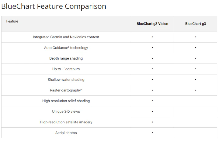
- Auto Guidance Technology that automatically generates recommended routes based on your vessel's depth requirements and overhead clearance specifications
- Depth Range Shading with up to 10 distinct depth ranges for visual identification of shallow and deep water zones
- Contour Mapping with detailed bottom structure depiction at 1-foot contour intervals for precise depth awareness
- NOAA Raster Cartography integration available through the ActiveCaptain® app for free downloadable reference charts
- User-defined Shallow Water Shading to highlight depth thresholds specific to your boating needs
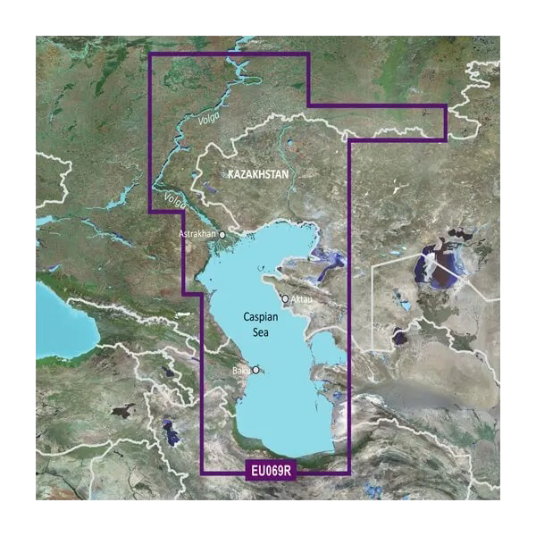
- Dual data source integration combining Garmin surveying with Navionics® cartography for comprehensive accuracy across the Caspian Sea, Volga River corridor from Ulyanovsk to Orsk
Data Insights
Mariners using advanced charting systems report a 30% reduction in navigation errors compared to standard paper or basic digital charts. Real-time data integration in BlueChart g3 enables more informed decision-making during complex navigation scenarios, particularly in areas with variable water depths, seasonal fluctuations, and heavy shipping traffic such as the Volga River corridor.
Usage Instructions
Insert the microSD/SD card into your compatible Garmin chartplotter, GPS, or marine device. Access the charts through the device's navigation menu and select the Caspian Sea, Volga River to Ulyanovsk and Orsk coverage area. Configure Auto Guidance settings by entering your vessel's maximum draft (keel depth) and air clearance requirements—the system will then suggest optimal routes avoiding shallow water and overhead obstructions. Use depth range shading and contour lines to cross-reference water conditions with your vessel specifications before committing to any route.
Design & Material
The Garmin BlueChart g3 chart card combines high-resolution digital mapping with a compact, durable physical format. The microSD/SD medium is engineered for reliability in marine environments while maintaining compatibility across Garmin's extensive device ecosystem, from handheld units to full-featured console plotters.
- Removable microSD/SD card format eliminates hardware dependencies and allows use across multiple Garmin devices
- High-resolution digital mapping with sharp text, clear depth contours, and detailed shoreline rendering
- Weather-resistant and saltwater-tolerant design suitable for long-term marine exposure
- Compact card dimensions (26mm x 24mm x 2.2mm) for easy storage and portability
- No batteries or external power required—integrates directly with host Garmin device's power system
- Integrated metadata supports searchable waypoint databases, route management, and real-time cursor positioning across the charted area
Final Verdict
For boaters, fishermen, and river pilots operating in the Caspian Sea and Volga River systems, this BlueChart g3 card delivers the detailed bottom data, automated route planning, and trusted dual-source cartography required for safe, efficient navigation. The 1-foot contour precision and depth range visualization eliminate guesswork in areas where shallow water and navigation obstructions pose real risks. If you're serious about reliable performance in this challenging region, the Garmin Caspian Sea, Volga River to Ulyanovsk and Orsk Charts (model 010-C1211-20) is the standard choice—upgrade your chartplotter today and navigate with confidence.


