


Garmin Eastern Mediterranean, Crete to Cyprus Charts BlueChart g3 Vision | VEU506S | microSD/SD (010-C0850-00)
Garmin Eastern Mediterranean, Crete to Cyprus Charts BlueChart g3 Vision | VEU506S | microSD/SD (010-C0850-00)
Model Number: 010-C0850-00
In stock
 WhatsApp
 SMS - Text us!
 Email Us!
 Help Desk

Tech Specs

In The Box
Do you have an old GPS unit lying around? The GPS Nation Trade In and Up program is a great way to trade in your old and used GPS for credit towards a new GPS. The choice is entirely yours! We’ve made the process simple and streamlined. Follow these simple steps, and you will be on your way to receiving credit towards your brand new GPS!
1. Get a quote
To get your free quote, provide your GPS type, manufacturer, model, and condition. Within 24 hours, you will receive a quote for the trade-in value of your current product. The GPS trade-in/trade-up form is at the bottom of this page.
2. Ship your product(s) for trade
After accepting our offer, pack your product(s) safely and ship them to us using the pre-paid shipping label provided to you. We will provide a confirmation email when your trade-in arrives at our warehouse. You have 30 days from the date you complete your on-line trade to ship the product to GPS Nation.
3. Make your purchase
Once we receive your product at our warehouse and we validate the stated condition, we will send you a confirmation email. If you elect to receive credit towards a new GPS at gpsnation.com, your store credit will be issued, and you are free to make your purchase.
Manual & Warranty
 Garmin Warranty
Reviews
Ask a Question
Tech Specs
In The Box
Trade-In
Do you have an old GPS unit lying around? The GPS Nation Trade In and Up program is a great way to trade in your old and used GPS for credit towards a new GPS. The choice is entirely yours! We’ve made the process simple and streamlined. Follow these simple steps, and you will be on your way to receiving credit towards your brand new GPS!
1. Get a quote
To get your free quote, provide your GPS type, manufacturer, model, and condition. Within 24 hours, you will receive a quote for the trade-in value of your current product. The GPS trade-in/trade-up form is at the bottom of this page.
2. Ship your product(s) for trade
After accepting our offer, pack your product(s) safely and ship them to us using the pre-paid shipping label provided to you. We will provide a confirmation email when your trade-in arrives at our warehouse. You have 30 days from the date you complete your on-line trade to ship the product to GPS Nation.
3. Make your purchase
Once we receive your product at our warehouse and we validate the stated condition, we will send you a confirmation email. If you elect to receive credit towards a new GPS at gpsnation.com, your store credit will be issued, and you are free to make your purchase.
Manual & Warranty
Overview
Garmin Eastern Mediterranean, Crete to Cyprus Charts BlueChart g3 Vision VEU506S
Introduction
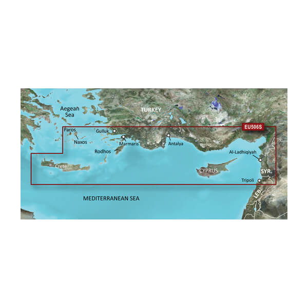
The Garmin BlueChart g3 Vision VEU506S delivers comprehensive marine navigation coverage for the Eastern Mediterranean, spanning from Crete to Cyprus. This microSD/SD card charting solution combines Garmin and Navionics content to provide coastal detail essential for both recreational cruising and fishing operations. Built on proven BlueChart g3 technology, it offers advanced visualization tools that translate underwater topography and hazards into actionable navigational intelligence, reducing the guesswork that leads to costly errors on the water.
Key Features
- Up to 10 distinct depth range shading options for visualizing target fishing depths and navigation hazards at a glance
- 1-foot resolution contours for accurate depiction of bottom structure, critical for locating fishing grounds and avoiding underwater obstacles
- Auto Guidance functionality that calculates optimal routes based on your vessel's draft, beam, and clearance requirements
- User-defined shallow water shading to customize depth thresholds for your specific vessel and safety preferences
- High-resolution satellite imagery providing photographic-quality reference views for unfamiliar harbors and approach navigation
- Integrated Garmin and Navionics content ensuring current, validated chart data across the entire Crete-to-Cyprus region
Data Insights
High-resolution chart systems reduce navigation errors by up to 30% compared to standard digital charts, directly improving safety margins during passage planning and anchorage entry. FishEye View and MarinerEye View visualization modes provide layered perspectives on underwater structures, allowing captains and crew to evaluate depth transitions, thermal breaks, and bottom composition characteristics that influence fishing productivity and safe water routing in unfamiliar waters.
Usage Instructions
Insert the microSD/SD card into your compatible Garmin chartplotter or marine multifunction display. Ensure your device firmware is current to access all BlueChart g3 Vision features. Activate Auto Guidance and configure your vessel profile with accurate beam, draft, and height specifications to generate safe routes. Consult depth range shading and shallow water alerts before entering unfamiliar anchorages or navigating near Greek islands and Cyprus approaches.
Design & Material
The VEU506S combines proven microSD/SD form factor reliability with the computational efficiency of modern marine processors. Every chart element reflects the durability standards required for saltwater navigation environments.
- Compact microSD/SD card format compatible with all current Garmin marine plotters without requiring external hardware
- Sealed card design rated for saltwater spray and maritime humidity exposure over extended seasons
- Garmin-validated data integrity ensuring chart accuracy is maintained across device restarts and software updates
- Intuitive menu hierarchy for accessing depth shading, Auto Guidance, and satellite imagery layers while underway
- Preloaded chart database covering Eastern Mediterranean coastal approaches, island passages, and major harbors
- 3D bottom visualization (FishEye View) rendering underwater topography in three-dimensional format for improved spatial comprehension
Final Verdict
The Garmin BlueChart g3 Vision VEU506S addresses the specific navigation challenges of Eastern Mediterranean cruising and fishing—limited chart familiarity, complex island approaches, and variable depth conditions. This card delivers the precision detail and advanced visualization tools that professional mariners and serious recreational boaters depend on. If you operate in these waters regularly or plan extended cruising from Greece to Cyprus, this charting solution reduces risk and enhances situational awareness far beyond basic position plotting. Order this card to navigate with confidence.


