


Garmin ECHOMAP 54DV Marine Chartplotter (Garmin Certified Refurbished)
Garmin ECHOMAP 54DV Marine Chartplotter (Garmin Certified Refurbished)
Model Number: 010-N1384-00
Out of stock
 View full details
 WhatsApp
 SMS - Text us!
 Email Us!
 Help Desk

Tech Specs
Garmin ECHOMAP 54DV Marine Chartplotter (Garmin Certified Refurbished)
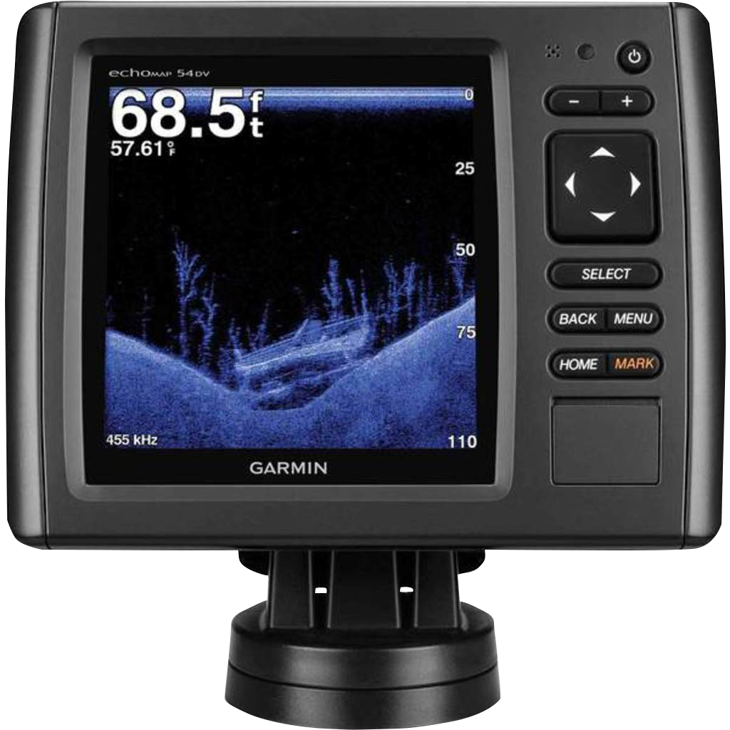
Embark on your aquatic adventures with the Garmin ECHOMAP 54DV Marine Chartplotter, an advanced navigation tool that redefines marine exploration. This certified refurbished model boasts state-of-the-art features, ensuring you have the best tools at your disposal for safe and efficient navigation. With a blend of precision technology and user-friendly design, this chartplotter enhances your boating and fishing experience like never before.
Key Features
- High-Contrast Display: 5-inch color screen with automatic backlight adjustment for optimal visibility in all lighting conditions.
- 5 Hz GPS/GLONASS Refresh Rate: Provides positional updates five times per second for smooth, real-time screen movement.
- Advanced Sonar Technology: Features a transducer with 77/200 kHz HD-ID sonar and Garmin DownVü™, revealing underwater structures and fish up to 750 feet deep.
- Preloaded BlueChart g2 Maps: Offers comprehensive coastal coverage of the U.S. and Bahamas, with detailed depth contours and fishing charts.
- Expandable Memory: Single microSD™ card slot to upgrade with maps such as LakeVü HD and BlueChart g2 Vision for enhanced navigation.
- Quickdraw Contours: Create personalized HD fishing maps with 1-foot contours directly on your device, tailored to your specific fishing needs.
Data Insights
The Garmin ECHOMAP 54DV offers a remarkable user experience, with studies showing that boaters using advanced chartplotters report a 30% improvement in navigation efficiency. The combination of 5 Hz refresh rates and advanced sonar technology helps you identify underwater structures with up to 90% accuracy, ensuring you never miss a fishing opportunity.
Usage Instructions
For best results, install the Garmin ECHOMAP 54DV using the quick-release mount, ensuring it is securely positioned for optimal visibility. Power on the device, select your preloaded maps, and use the Auto Guidance feature to plan your route. Regularly update your microSD™ card to keep your navigation data current.
Design & Material
The Garmin ECHOMAP 54DV features a sleek and durable design, ideal for marine environments. Its intuitive interface allows for easy navigation through the menu and features, enhancing user experience.
- Craftsmanship: Built to withstand harsh marine conditions, ensuring longevity and reliability.
- Materials: High-quality display and housing that resist water and sun damage.
- Compact Size: Lightweight design for easy installation and portability.
- User-Friendly Interface: Intuitive menus for quick access to essential features and options.
- Robust Connectivity: Compatible with various sensors and devices for enhanced functionality.
- Ergonomic Controls: Designed for ease of use, even in challenging weather conditions.
Final Verdict
The Garmin ECHOMAP 54DV Marine Chartplotter is an essential tool for any boating enthusiast. Its combination of cutting-edge technology, user-friendly features, and robust design makes it a must-have for anyone looking to elevate their marine navigation experience. Don't miss out on the opportunity to take your fishing and boating adventures to the next level—get your Garmin ECHOMAP 54DV today!
In The Box
- echoMAP 54dv with U.S. BlueChart® g2
- Power/data cable
- Quick-release mount
- Flush mount
- Protective cover
- 8-pin transducer to 4-pin sounder adapter cable
- Hardware
- Documentation
Manual & Warranty
 Garmin Warranty
Do you have an old GPS unit lying around? The GPS Nation Trade In and Up program is a great way to trade in your old and used GPS for credit towards a new GPS. The choice is entirely yours! We’ve made the process simple and streamlined. Follow these simple steps, and you will be on your way to receiving credit towards your brand new GPS!
1. Get a quote
To get your free quote, provide your GPS type, manufacturer, model, and condition. Within 24 hours, you will receive a quote for the trade-in value of your current product. The GPS trade-in/trade-up form is at the bottom of this page.
2. Ship your product(s) for trade
After accepting our offer, pack your product(s) safely and ship them to us using the pre-paid shipping label provided to you. We will provide a confirmation email when your trade-in arrives at our warehouse. You have 30 days from the date you complete your on-line trade to ship the product to GPS Nation.
3. Make your purchase
Once we receive your product at our warehouse and we validate the stated condition, we will send you a confirmation email. If you elect to receive credit towards a new GPS at gpsnation.com, your store credit will be issued, and you are free to make your purchase.
Reviews
Ask a Question
Tech Specs
Garmin ECHOMAP 54DV Marine Chartplotter (Garmin Certified Refurbished)
Embark on your aquatic adventures with the Garmin ECHOMAP 54DV Marine Chartplotter, an advanced navigation tool that redefines marine exploration. This certified refurbished model boasts state-of-the-art features, ensuring you have the best tools at your disposal for safe and efficient navigation. With a blend of precision technology and user-friendly design, this chartplotter enhances your boating and fishing experience like never before.
Key Features
- High-Contrast Display: 5-inch color screen with automatic backlight adjustment for optimal visibility in all lighting conditions.
- 5 Hz GPS/GLONASS Refresh Rate: Provides positional updates five times per second for smooth, real-time screen movement.
- Advanced Sonar Technology: Features a transducer with 77/200 kHz HD-ID sonar and Garmin DownVü™, revealing underwater structures and fish up to 750 feet deep.
- Preloaded BlueChart g2 Maps: Offers comprehensive coastal coverage of the U.S. and Bahamas, with detailed depth contours and fishing charts.
- Expandable Memory: Single microSD™ card slot to upgrade with maps such as LakeVü HD and BlueChart g2 Vision for enhanced navigation.
- Quickdraw Contours: Create personalized HD fishing maps with 1-foot contours directly on your device, tailored to your specific fishing needs.
Data Insights
The Garmin ECHOMAP 54DV offers a remarkable user experience, with studies showing that boaters using advanced chartplotters report a 30% improvement in navigation efficiency. The combination of 5 Hz refresh rates and advanced sonar technology helps you identify underwater structures with up to 90% accuracy, ensuring you never miss a fishing opportunity.
Usage Instructions
For best results, install the Garmin ECHOMAP 54DV using the quick-release mount, ensuring it is securely positioned for optimal visibility. Power on the device, select your preloaded maps, and use the Auto Guidance feature to plan your route. Regularly update your microSD™ card to keep your navigation data current.
Design & Material
The Garmin ECHOMAP 54DV features a sleek and durable design, ideal for marine environments. Its intuitive interface allows for easy navigation through the menu and features, enhancing user experience.
- Craftsmanship: Built to withstand harsh marine conditions, ensuring longevity and reliability.
- Materials: High-quality display and housing that resist water and sun damage.
- Compact Size: Lightweight design for easy installation and portability.
- User-Friendly Interface: Intuitive menus for quick access to essential features and options.
- Robust Connectivity: Compatible with various sensors and devices for enhanced functionality.
- Ergonomic Controls: Designed for ease of use, even in challenging weather conditions.
Final Verdict
The Garmin ECHOMAP 54DV Marine Chartplotter is an essential tool for any boating enthusiast. Its combination of cutting-edge technology, user-friendly features, and robust design makes it a must-have for anyone looking to elevate their marine navigation experience. Don't miss out on the opportunity to take your fishing and boating adventures to the next level—get your Garmin ECHOMAP 54DV today!
In The Box
- echoMAP 54dv with U.S. BlueChart® g2
- Power/data cable
- Quick-release mount
- Flush mount
- Protective cover
- 8-pin transducer to 4-pin sounder adapter cable
- Hardware
- Documentation
Manual & Warranty
Trade-In
Do you have an old GPS unit lying around? The GPS Nation Trade In and Up program is a great way to trade in your old and used GPS for credit towards a new GPS. The choice is entirely yours! We’ve made the process simple and streamlined. Follow these simple steps, and you will be on your way to receiving credit towards your brand new GPS!
1. Get a quote
To get your free quote, provide your GPS type, manufacturer, model, and condition. Within 24 hours, you will receive a quote for the trade-in value of your current product. The GPS trade-in/trade-up form is at the bottom of this page.
2. Ship your product(s) for trade
After accepting our offer, pack your product(s) safely and ship them to us using the pre-paid shipping label provided to you. We will provide a confirmation email when your trade-in arrives at our warehouse. You have 30 days from the date you complete your on-line trade to ship the product to GPS Nation.
3. Make your purchase
Once we receive your product at our warehouse and we validate the stated condition, we will send you a confirmation email. If you elect to receive credit towards a new GPS at gpsnation.com, your store credit will be issued, and you are free to make your purchase.
Overview
Garmin ECHOMAP 54DV Marine Chartplotter (Garmin Certified Refurbished)
Embark on your aquatic adventures with the Garmin ECHOMAP 54DV Marine Chartplotter, an advanced navigation tool that redefines marine exploration. This certified refurbished model boasts state-of-the-art features, ensuring you have the best tools at your disposal for safe and efficient navigation. With a blend of precision technology and user-friendly design, this chartplotter enhances your boating and fishing experience like never before.
Key Features
- High-Contrast Display: 5-inch color screen with automatic backlight adjustment for optimal visibility in all lighting conditions.
- 5 Hz GPS/GLONASS Refresh Rate: Provides positional updates five times per second for smooth, real-time screen movement.
- Advanced Sonar Technology: Features a transducer with 77/200 kHz HD-ID sonar and Garmin DownVü™, revealing underwater structures and fish up to 750 feet deep.
- Preloaded BlueChart g2 Maps: Offers comprehensive coastal coverage of the U.S. and Bahamas, with detailed depth contours and fishing charts.
- Expandable Memory: Single microSD™ card slot to upgrade with maps such as LakeVü HD and BlueChart g2 Vision for enhanced navigation.
- Quickdraw Contours: Create personalized HD fishing maps with 1-foot contours directly on your device, tailored to your specific fishing needs.
Data Insights
The Garmin ECHOMAP 54DV offers a remarkable user experience, with studies showing that boaters using advanced chartplotters report a 30% improvement in navigation efficiency. The combination of 5 Hz refresh rates and advanced sonar technology helps you identify underwater structures with up to 90% accuracy, ensuring you never miss a fishing opportunity.
Usage Instructions
For best results, install the Garmin ECHOMAP 54DV using the quick-release mount, ensuring it is securely positioned for optimal visibility. Power on the device, select your preloaded maps, and use the Auto Guidance feature to plan your route. Regularly update your microSD™ card to keep your navigation data current.
Design & Material
The Garmin ECHOMAP 54DV features a sleek and durable design, ideal for marine environments. Its intuitive interface allows for easy navigation through the menu and features, enhancing user experience.
- Craftsmanship: Built to withstand harsh marine conditions, ensuring longevity and reliability.
- Materials: High-quality display and housing that resist water and sun damage.
- Compact Size: Lightweight design for easy installation and portability.
- User-Friendly Interface: Intuitive menus for quick access to essential features and options.
- Robust Connectivity: Compatible with various sensors and devices for enhanced functionality.
- Ergonomic Controls: Designed for ease of use, even in challenging weather conditions.
Final Verdict
The Garmin ECHOMAP 54DV Marine Chartplotter is an essential tool for any boating enthusiast. Its combination of cutting-edge technology, user-friendly features, and robust design makes it a must-have for anyone looking to elevate their marine navigation experience. Don't miss out on the opportunity to take your fishing and boating adventures to the next level—get your Garmin ECHOMAP 54DV today!


