


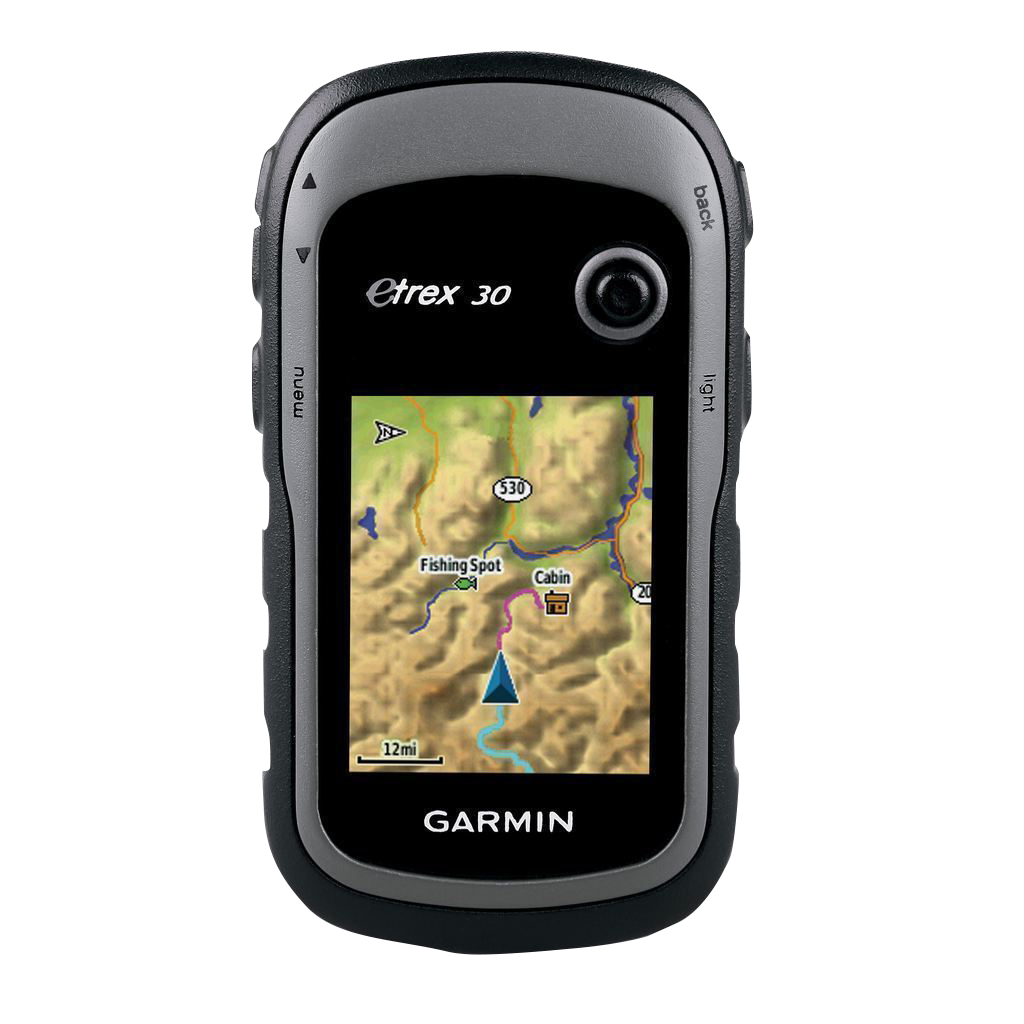
Garmin eTrex 30, Rugged & Lightweight GPS with Maps (Garmin Certified Refurbished)
Garmin eTrex 30, Rugged & Lightweight GPS with Maps (Garmin Certified Refurbished)
Model Number: 010-N0970-20
Out of stock
 View full details
 WhatsApp
 SMS - Text us!
 Email Us!
 Help Desk

Tech Specs
Garmin eTrex 30, Rugged & Lightweight GPS with Maps (Garmin Certified Refurbished)
Discover the great outdoors with the Garmin eTrex 30, a rugged yet lightweight GPS device designed for adventurers and outdoor enthusiasts. This portable navigator combines advanced technology with a durable build, ensuring that you stay on track no matter where your adventures take you. From hiking and biking to boating and geocaching, the eTrex 30 empowers you to explore confidently and efficiently.
Key Features
- Enhanced Display: 2.2" sunlight-readable display with 65K colors for clear visibility.
- Waterproof Rating: IPX7 waterproof rating, allowing for use in wet conditions without worry.
- Multi-Satellite Support: Tracks GPS and GLONASS satellites for improved positioning accuracy.
- Built-in 3-Axis Compass: Tilt-compensated electronic compass for accurate heading, even when stationary.
- Barometric Altimeter: Monitors altitude by tracking pressure changes, aiding in weather prediction.
- Expandable Memory: 1.7 GB internal memory plus microSD card slot for extensive map storage.
Data Insights
The Garmin eTrex 30 significantly enhances your outdoor navigation experience with its ability to access both GPS and GLONASS satellites, resulting in a faster positioning time by up to 20% compared to traditional GPS systems. This dual-satellite capability means greater accuracy and reliability, especially in challenging environments like dense forests or mountainous areas.
Usage Instructions
To maximize the capabilities of your Garmin eTrex 30, ensure you fully charge the device before your outdoor activities. Familiarize yourself with the menu for easy access to maps and routes. Utilize the built-in 3-axis compass and barometric altimeter to keep track of your heading and altitude changes. Regularly update your maps to stay current on terrain and navigational aids.
Design & Material
Crafted for durability, the Garmin eTrex 30 features a rugged design that can withstand the elements. It is lightweight, making it easy to carry during long excursions. The device is designed to be user-friendly, with intuitive navigation controls that enhance the overall user experience.
- Material: Durable plastic casing that resists impacts and scratches.
- Compact Size: Lightweight design, weighing just 5 ounces for easy portability.
- Ergonomic Shape: Designed for comfortable handling during extended use.
- Sunlight-readable Display: Ensures visibility in all lighting conditions.
- Easy Button Navigation: Simple interface allows for quick access to features.
- Mounting Options: Compatible with various mounts for different activities.
Final Verdict
The Garmin eTrex 30 is an essential tool for anyone looking to enhance their outdoor adventures. Its robust features, combined with its lightweight and rugged design, make it the perfect companion for navigating the great outdoors. Don't miss out on your next adventure—experience the reliability and performance of the Garmin eTrex 30 today!
In The Box
- eTrex 30
- USB cable
- Quickstart Guide
Manual & Warranty
 Garmin Warranty
Do you have an old GPS unit lying around? The GPS Nation Trade In and Up program is a great way to trade in your old and used GPS for credit towards a new GPS. The choice is entirely yours! We’ve made the process simple and streamlined. Follow these simple steps, and you will be on your way to receiving credit towards your brand new GPS!
1. Get a quote
To get your free quote, provide your GPS type, manufacturer, model, and condition. Within 24 hours, you will receive a quote for the trade-in value of your current product. The GPS trade-in/trade-up form is at the bottom of this page.
2. Ship your product(s) for trade
After accepting our offer, pack your product(s) safely and ship them to us using the pre-paid shipping label provided to you. We will provide a confirmation email when your trade-in arrives at our warehouse. You have 30 days from the date you complete your on-line trade to ship the product to GPS Nation.
3. Make your purchase
Once we receive your product at our warehouse and we validate the stated condition, we will send you a confirmation email. If you elect to receive credit towards a new GPS at gpsnation.com, your store credit will be issued, and you are free to make your purchase.
Reviews
Ask a Question
Tech Specs
Garmin eTrex 30, Rugged & Lightweight GPS with Maps (Garmin Certified Refurbished)
Discover the great outdoors with the Garmin eTrex 30, a rugged yet lightweight GPS device designed for adventurers and outdoor enthusiasts. This portable navigator combines advanced technology with a durable build, ensuring that you stay on track no matter where your adventures take you. From hiking and biking to boating and geocaching, the eTrex 30 empowers you to explore confidently and efficiently.
Key Features
- Enhanced Display: 2.2" sunlight-readable display with 65K colors for clear visibility.
- Waterproof Rating: IPX7 waterproof rating, allowing for use in wet conditions without worry.
- Multi-Satellite Support: Tracks GPS and GLONASS satellites for improved positioning accuracy.
- Built-in 3-Axis Compass: Tilt-compensated electronic compass for accurate heading, even when stationary.
- Barometric Altimeter: Monitors altitude by tracking pressure changes, aiding in weather prediction.
- Expandable Memory: 1.7 GB internal memory plus microSD card slot for extensive map storage.
Data Insights
The Garmin eTrex 30 significantly enhances your outdoor navigation experience with its ability to access both GPS and GLONASS satellites, resulting in a faster positioning time by up to 20% compared to traditional GPS systems. This dual-satellite capability means greater accuracy and reliability, especially in challenging environments like dense forests or mountainous areas.
Usage Instructions
To maximize the capabilities of your Garmin eTrex 30, ensure you fully charge the device before your outdoor activities. Familiarize yourself with the menu for easy access to maps and routes. Utilize the built-in 3-axis compass and barometric altimeter to keep track of your heading and altitude changes. Regularly update your maps to stay current on terrain and navigational aids.
Design & Material
Crafted for durability, the Garmin eTrex 30 features a rugged design that can withstand the elements. It is lightweight, making it easy to carry during long excursions. The device is designed to be user-friendly, with intuitive navigation controls that enhance the overall user experience.
- Material: Durable plastic casing that resists impacts and scratches.
- Compact Size: Lightweight design, weighing just 5 ounces for easy portability.
- Ergonomic Shape: Designed for comfortable handling during extended use.
- Sunlight-readable Display: Ensures visibility in all lighting conditions.
- Easy Button Navigation: Simple interface allows for quick access to features.
- Mounting Options: Compatible with various mounts for different activities.
Final Verdict
The Garmin eTrex 30 is an essential tool for anyone looking to enhance their outdoor adventures. Its robust features, combined with its lightweight and rugged design, make it the perfect companion for navigating the great outdoors. Don't miss out on your next adventure—experience the reliability and performance of the Garmin eTrex 30 today!
In The Box
- eTrex 30
- USB cable
- Quickstart Guide
Manual & Warranty
Trade-In
Do you have an old GPS unit lying around? The GPS Nation Trade In and Up program is a great way to trade in your old and used GPS for credit towards a new GPS. The choice is entirely yours! We’ve made the process simple and streamlined. Follow these simple steps, and you will be on your way to receiving credit towards your brand new GPS!
1. Get a quote
To get your free quote, provide your GPS type, manufacturer, model, and condition. Within 24 hours, you will receive a quote for the trade-in value of your current product. The GPS trade-in/trade-up form is at the bottom of this page.
2. Ship your product(s) for trade
After accepting our offer, pack your product(s) safely and ship them to us using the pre-paid shipping label provided to you. We will provide a confirmation email when your trade-in arrives at our warehouse. You have 30 days from the date you complete your on-line trade to ship the product to GPS Nation.
3. Make your purchase
Once we receive your product at our warehouse and we validate the stated condition, we will send you a confirmation email. If you elect to receive credit towards a new GPS at gpsnation.com, your store credit will be issued, and you are free to make your purchase.
Overview
Garmin eTrex 30, Rugged & Lightweight GPS with Maps (Garmin Certified Refurbished)
Discover the great outdoors with the Garmin eTrex 30, a rugged yet lightweight GPS device designed for adventurers and outdoor enthusiasts. This portable navigator combines advanced technology with a durable build, ensuring that you stay on track no matter where your adventures take you. From hiking and biking to boating and geocaching, the eTrex 30 empowers you to explore confidently and efficiently.
Key Features
- Enhanced Display: 2.2" sunlight-readable display with 65K colors for clear visibility.
- Waterproof Rating: IPX7 waterproof rating, allowing for use in wet conditions without worry.
- Multi-Satellite Support: Tracks GPS and GLONASS satellites for improved positioning accuracy.
- Built-in 3-Axis Compass: Tilt-compensated electronic compass for accurate heading, even when stationary.
- Barometric Altimeter: Monitors altitude by tracking pressure changes, aiding in weather prediction.
- Expandable Memory: 1.7 GB internal memory plus microSD card slot for extensive map storage.
Data Insights
The Garmin eTrex 30 significantly enhances your outdoor navigation experience with its ability to access both GPS and GLONASS satellites, resulting in a faster positioning time by up to 20% compared to traditional GPS systems. This dual-satellite capability means greater accuracy and reliability, especially in challenging environments like dense forests or mountainous areas.
Usage Instructions
To maximize the capabilities of your Garmin eTrex 30, ensure you fully charge the device before your outdoor activities. Familiarize yourself with the menu for easy access to maps and routes. Utilize the built-in 3-axis compass and barometric altimeter to keep track of your heading and altitude changes. Regularly update your maps to stay current on terrain and navigational aids.
Design & Material
Crafted for durability, the Garmin eTrex 30 features a rugged design that can withstand the elements. It is lightweight, making it easy to carry during long excursions. The device is designed to be user-friendly, with intuitive navigation controls that enhance the overall user experience.
- Material: Durable plastic casing that resists impacts and scratches.
- Compact Size: Lightweight design, weighing just 5 ounces for easy portability.
- Ergonomic Shape: Designed for comfortable handling during extended use.
- Sunlight-readable Display: Ensures visibility in all lighting conditions.
- Easy Button Navigation: Simple interface allows for quick access to features.
- Mounting Options: Compatible with various mounts for different activities.
Final Verdict
The Garmin eTrex 30 is an essential tool for anyone looking to enhance their outdoor adventures. Its robust features, combined with its lightweight and rugged design, make it the perfect companion for navigating the great outdoors. Don't miss out on your next adventure—experience the reliability and performance of the Garmin eTrex 30 today!


