


Garmin Finland, Kuopia to Lappeenranta Charts BlueChart g3 Vision | VEU489S | microSD/SD
Garmin Finland, Kuopia to Lappeenranta Charts BlueChart g3 Vision | VEU489S | microSD/SD
Model Number: 010-C0833-00
In stock
 WhatsApp
 SMS - Text us!
 Email Us!
 Help Desk

Tech Specs
In The Box
Do you have an old GPS unit lying around? The GPS Nation Trade In and Up program is a great way to trade in your old and used GPS for credit towards a new GPS. The choice is entirely yours! We’ve made the process simple and streamlined. Follow these simple steps, and you will be on your way to receiving credit towards your brand new GPS!
1. Get a quote
To get your free quote, provide your GPS type, manufacturer, model, and condition. Within 24 hours, you will receive a quote for the trade-in value of your current product. The GPS trade-in/trade-up form is at the bottom of this page.
2. Ship your product(s) for trade
After accepting our offer, pack your product(s) safely and ship them to us using the pre-paid shipping label provided to you. We will provide a confirmation email when your trade-in arrives at our warehouse. You have 30 days from the date you complete your on-line trade to ship the product to GPS Nation.
3. Make your purchase
Once we receive your product at our warehouse and we validate the stated condition, we will send you a confirmation email. If you elect to receive credit towards a new GPS at gpsnation.com, your store credit will be issued, and you are free to make your purchase.
Manual & Warranty
 Garmin Warranty
Reviews
Ask a Question
Tech Specs
In The Box
Trade-In
Do you have an old GPS unit lying around? The GPS Nation Trade In and Up program is a great way to trade in your old and used GPS for credit towards a new GPS. The choice is entirely yours! We’ve made the process simple and streamlined. Follow these simple steps, and you will be on your way to receiving credit towards your brand new GPS!
1. Get a quote
To get your free quote, provide your GPS type, manufacturer, model, and condition. Within 24 hours, you will receive a quote for the trade-in value of your current product. The GPS trade-in/trade-up form is at the bottom of this page.
2. Ship your product(s) for trade
After accepting our offer, pack your product(s) safely and ship them to us using the pre-paid shipping label provided to you. We will provide a confirmation email when your trade-in arrives at our warehouse. You have 30 days from the date you complete your on-line trade to ship the product to GPS Nation.
3. Make your purchase
Once we receive your product at our warehouse and we validate the stated condition, we will send you a confirmation email. If you elect to receive credit towards a new GPS at gpsnation.com, your store credit will be issued, and you are free to make your purchase.
Manual & Warranty
Overview
Garmin BlueChart g3 Vision Finland: Kuopio to Lappeenranta Maritime Charts (VEU489S)
Introduction
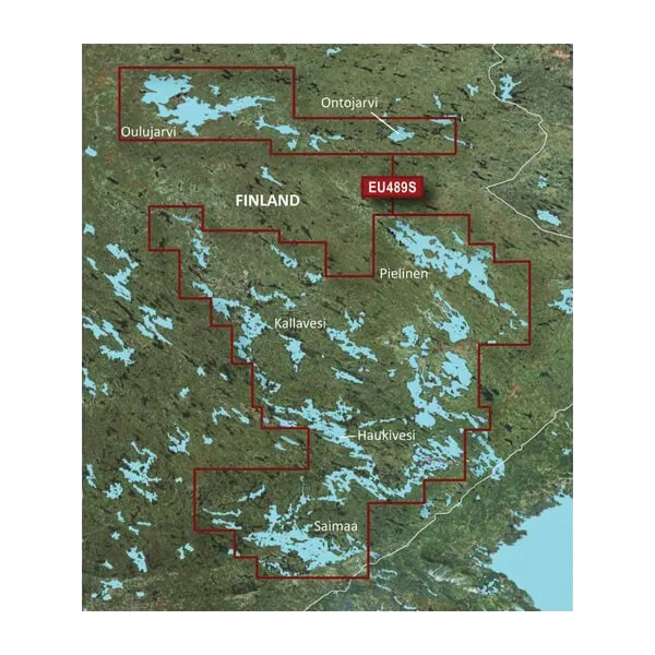
The Garmin BlueChart g3 Vision VEU489S microSD/SD card delivers high-resolution nautical charting for Finland's inland waterways spanning from Kuopio to Lappeenranta. This marine navigation solution combines Garmin and Navionics data to provide boaters with detailed bottom structure, depth contours, and real-time spatial awareness across multiple Finnish lake systems including Kallavesi, Pielinen, Haukivesi, and Saimaa. The chart card integrates satellite imagery overlays with navigational data to enhance route planning, hazard avoidance, and fishing location identification on waters where accuracy directly impacts safety and journey efficiency.
Key Features
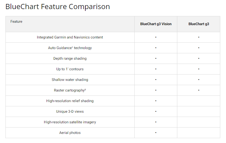
- Auto Guidance Technology with automatic route calculation based on vessel draft depth and overhead clearance requirements
- Depth Range Shading displaying up to 10 customizable depth ranges for real-time hazard visualization
- High-Resolution 1-Foot Contours providing precise bottom topography representation for fishing and port planning
- Shallow Water Shading with user-defined depth thresholds to prevent accidental grounding in navigation channels
- Satellite Imagery Overlay combining photographic context with navigational vector data for enhanced situational awareness
- Integrated Garmin-Navionics Data Foundation delivering verified charting across comprehensive Finnish lake coverage area
Data Insights
Navigation systems equipped with advanced charting capabilities reduce boating navigation errors by up to 30%, according to marine safety research. The VEU489S chart coverage encompasses extensive Finnish lake systems and tributaries, with precise bathymetric data that enables boaters to identify safe passage corridors, locate fishing grounds by depth preference, and plan efficient routes across complex water networks where traditional paper charts lack real-time depth and terrain detail.
Usage Instructions
Insert the microSD/SD card into a compatible Garmin marine GPS device to load the Kuopio-Lappeenranta chart data. Access Auto Guidance settings to define your vessel's draft and air clearance specifications—the system automatically calculates safe routes through shallow areas and under bridges. Activate depth range shading layers to highlight underwater structure and hazards relevant to your navigation priorities. Download latest chart updates through Garmin's update service to ensure access to recently corrected depths, aids to navigation, and other critical waterway changes.
Design & Material
The VEU489S employs a durable microSD/SD card format engineered for reliable data storage in marine environments. The physical card withstands moisture and temperature fluctuations common to boat storage and operation. The accompanying charting software utilizes an intuitive display interface that prioritizes essential navigation data—depth contours, waypoints, hazards, and routes—without cluttering the screen with unnecessary layers.
- Robust MicroSD/SD Card Construction with metal contacts and protective casing for secure device insertion and data integrity
- Marine-Grade Durability designed to function across wide temperature and humidity ranges typical of Nordic waterways
- Integrated Garmin-Navionics Dataset combining verified coastal and inland charting sources
- Satellite Imagery Foundation providing visual reference for chart interpretation and natural landmark recognition
- Real-Time Depth and Contour Data enabling dynamic hazard assessment during navigation
- Streamlined Display Architecture prioritizing critical navigation elements while maintaining comprehensive data accessibility
Final Verdict
The Garmin BlueChart g3 Vision VEU489S eliminates navigation guesswork on Finland's complex inland lake systems. Whether you pilot a fishing boat, cruiser, or commercial vessel through the Kuopio-to-Lappeenranta corridor, this chart card delivers the precise bathymetric detail, Auto Guidance routing, and satellite context necessary for confident, efficient water travel. Install the VEU489S into your Garmin device today to navigate with the clarity and safety that only integrated professional charting data provides.


