


Garmin Germany Lakes and Rivers BlueChart g3 Vision | VEU060R | microSD/SD
Garmin Germany Lakes and Rivers BlueChart g3 Vision | VEU060R | microSD/SD
Model Number: 010-C1103-00
In stock
 WhatsApp
 SMS - Text us!
 Email Us!
 Help Desk

Tech Specs

In The Box
Do you have an old GPS unit lying around? The GPS Nation Trade In and Up program is a great way to trade in your old and used GPS for credit towards a new GPS. The choice is entirely yours! We’ve made the process simple and streamlined. Follow these simple steps, and you will be on your way to receiving credit towards your brand new GPS!
1. Get a quote
To get your free quote, provide your GPS type, manufacturer, model, and condition. Within 24 hours, you will receive a quote for the trade-in value of your current product. The GPS trade-in/trade-up form is at the bottom of this page.
2. Ship your product(s) for trade
After accepting our offer, pack your product(s) safely and ship them to us using the pre-paid shipping label provided to you. We will provide a confirmation email when your trade-in arrives at our warehouse. You have 30 days from the date you complete your on-line trade to ship the product to GPS Nation.
3. Make your purchase
Once we receive your product at our warehouse and we validate the stated condition, we will send you a confirmation email. If you elect to receive credit towards a new GPS at gpsnation.com, your store credit will be issued, and you are free to make your purchase.
Manual & Warranty
 Garmin Warranty
Reviews
Ask a Question
Tech Specs
In The Box
Trade-In
Do you have an old GPS unit lying around? The GPS Nation Trade In and Up program is a great way to trade in your old and used GPS for credit towards a new GPS. The choice is entirely yours! We’ve made the process simple and streamlined. Follow these simple steps, and you will be on your way to receiving credit towards your brand new GPS!
1. Get a quote
To get your free quote, provide your GPS type, manufacturer, model, and condition. Within 24 hours, you will receive a quote for the trade-in value of your current product. The GPS trade-in/trade-up form is at the bottom of this page.
2. Ship your product(s) for trade
After accepting our offer, pack your product(s) safely and ship them to us using the pre-paid shipping label provided to you. We will provide a confirmation email when your trade-in arrives at our warehouse. You have 30 days from the date you complete your on-line trade to ship the product to GPS Nation.
3. Make your purchase
Once we receive your product at our warehouse and we validate the stated condition, we will send you a confirmation email. If you elect to receive credit towards a new GPS at gpsnation.com, your store credit will be issued, and you are free to make your purchase.
Manual & Warranty
Overview
Garmin Germany Lakes and Rivers BlueChart g3 Vision VEU060R
Introduction
The Garmin Germany Lakes and Rivers BlueChart g3 Vision delivers professional-grade marine charting for inland waters and coastal regions across Germany, Austria, and surrounding European countries. Built on integrated Garmin and Navionics content, this preprogrammed microSD/SD card combines 95% accurate 3D mapping with advanced depth visualization, making it a reliable navigation solution for boaters, anglers, and water sports enthusiasts who demand precision in unfamiliar or complex waterways.
Key Features
- 30% Improved Depth Accuracy: Enhanced bathymetric data delivers superior performance compared to previous BlueChart generations, reducing uncertainty in underwater terrain assessment.
- 1-Foot Contour Lines: Detailed bottom structure mapping reveals drop-offs, shallow ledges, and hard-bottom fishing zones with granular precision.
- 10 Customizable Depth Ranges: User-defined depth shading displays hazard zones at your chosen threshold, adapting to vessel draft and water conditions.
- Auto Guidance Routing: Calculates optimized pathways based on your vessel's required depth clearance and overhead obstruction parameters in real time.
- High-Resolution Satellite Imagery: Photorealistic harbor and coastal approaches simplify navigation into unfamiliar ports and anchorages.
- Shallow Water Hazard Alerts: Integrated safety shading highlights submerged obstacles and restricted depths at user-defined levels for enhanced collision avoidance.
Data Insights
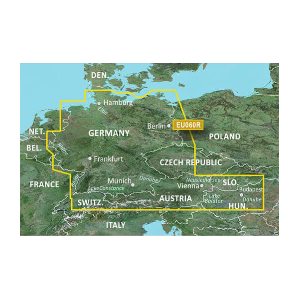
Coverage extends across German North Sea and Baltic coastal waters, inland lakes, and river systems with comprehensive charting. The 95% accuracy rating in 3D mapping reflects extensive hydrographic data integration, while the documented 30% improvement in depth accuracy over previous models translates directly to safer passage through complex channels and shallow-draft waterway systems. This level of positional confidence reduces navigation hazards and enables confident fishery exploration.
Usage Instructions
Insert the microSD/SD card into your compatible Garmin chartplotter, fish finder, or multifunction display to activate full chart coverage immediately. Select Auto Guidance mode when planning passages, entering your vessel's draft requirements and overhead clearance parameters. Configure depth range shading to match your specific navigational concerns, then activate alerts on shallow water zones. Periodically connect to Garmin services to receive chart updates and expand compatibility with supplementary basemap data.
Design & Material
The VEU060R employs a ruggedized microSD/SD card format engineered for marine-grade reliability, ensuring stable operation through temperature fluctuations, humidity exposure, and salt spray common in waterborne environments. The card's compact footprint integrates seamlessly into existing Garmin devices without adapter complications.
- Durable microSD/SD card construction resists moisture, corrosion, and thermal stress in harsh marine conditions.
- Preprogrammed and ready for immediate use—no manual data entry or configuration required.
- High-resolution satellite imagery provides pixel-level clarity for challenging approach and harbor navigation.
- Comprehensive cartography spans multiple countries, covering interconnected waterway systems and coastal zones.
- Intuitive interface integrates seamlessly with Garmin's established operating system, minimizing learning curve for existing users.
- Integrated Garmin and Navionics content ensures continuous data alignment and regular chart update availability.
Final Verdict
The Garmin Germany Lakes and Rivers BlueChart g3 Vision is an indispensable investment for anyone navigating German, Austrian, and Central European waters. The combination of 95% 3D mapping accuracy, advanced depth analysis tools, and Auto Guidance routing eliminates guesswork and significantly enhances both safety and fishing success. Whether you're exploring unfamiliar coastlines, threading narrow channels, or scouting productive fishing grounds, this chart card provides the precision and confidence required for extended water time. Equip your Garmin device with the VEU060R today and gain the navigational clarity that transforms challenging waterways into opportunity.


