


Garmin Goteborg to Fyn Charts BlueChart g3 Vision | VEU458S | microSD/SD
Garmin Goteborg to Fyn Charts BlueChart g3 Vision | VEU458S | microSD/SD
Model Number: 010-C0802-00
In stock
 WhatsApp
 SMS - Text us!
 Email Us!
 Help Desk

Tech Specs

In The Box
Do you have an old GPS unit lying around? The GPS Nation Trade In and Up program is a great way to trade in your old and used GPS for credit towards a new GPS. The choice is entirely yours! We’ve made the process simple and streamlined. Follow these simple steps, and you will be on your way to receiving credit towards your brand new GPS!
1. Get a quote
To get your free quote, provide your GPS type, manufacturer, model, and condition. Within 24 hours, you will receive a quote for the trade-in value of your current product. The GPS trade-in/trade-up form is at the bottom of this page.
2. Ship your product(s) for trade
After accepting our offer, pack your product(s) safely and ship them to us using the pre-paid shipping label provided to you. We will provide a confirmation email when your trade-in arrives at our warehouse. You have 30 days from the date you complete your on-line trade to ship the product to GPS Nation.
3. Make your purchase
Once we receive your product at our warehouse and we validate the stated condition, we will send you a confirmation email. If you elect to receive credit towards a new GPS at gpsnation.com, your store credit will be issued, and you are free to make your purchase.
Manual & Warranty
 Garmin Warranty
Reviews
Ask a Question
Tech Specs
In The Box
Trade-In
Do you have an old GPS unit lying around? The GPS Nation Trade In and Up program is a great way to trade in your old and used GPS for credit towards a new GPS. The choice is entirely yours! We’ve made the process simple and streamlined. Follow these simple steps, and you will be on your way to receiving credit towards your brand new GPS!
1. Get a quote
To get your free quote, provide your GPS type, manufacturer, model, and condition. Within 24 hours, you will receive a quote for the trade-in value of your current product. The GPS trade-in/trade-up form is at the bottom of this page.
2. Ship your product(s) for trade
After accepting our offer, pack your product(s) safely and ship them to us using the pre-paid shipping label provided to you. We will provide a confirmation email when your trade-in arrives at our warehouse. You have 30 days from the date you complete your on-line trade to ship the product to GPS Nation.
3. Make your purchase
Once we receive your product at our warehouse and we validate the stated condition, we will send you a confirmation email. If you elect to receive credit towards a new GPS at gpsnation.com, your store credit will be issued, and you are free to make your purchase.
Manual & Warranty
Overview
Garmin Göteborg to Fyn Charts BlueChart g3 Vision | VEU458S | microSD/SD Card
Introduction
The Garmin Göteborg to Fyn Charts BlueChart g3 Vision (model VEU458S) delivers detailed electronic charting for the Baltic Sea region spanning Sweden's west coast to Danish waters. Built for both recreational cruisers and serious anglers, this microSD/SD card integrates Garmin and Navionics data to provide real-time navigational intelligence with measurable improvements in route planning accuracy. Unlike static paper charts, this digital solution adapts your device's display to sea conditions, depth zones, and underwater structure in seconds.
Key Features
- Auto Guidance Technology: Calculates optimal safe routes based on your specified water depth and overhead clearance requirements
- Depth Range Shading: Displays up to 10 distinct depth zones simultaneously for quick identification of navigation hazards
- 1-Foot Contour Lines: Reveals detailed bottom topography and structure changes critical for finding fish and anchoring sites
- High-Resolution Satellite Imagery Overlay: Combines real-world coastal imagery with chart data for precise orientation and landmark identification
- Shallow Water Shading: User-configurable depth threshold alerts that highlight dangerous shallows relative to your vessel's draft
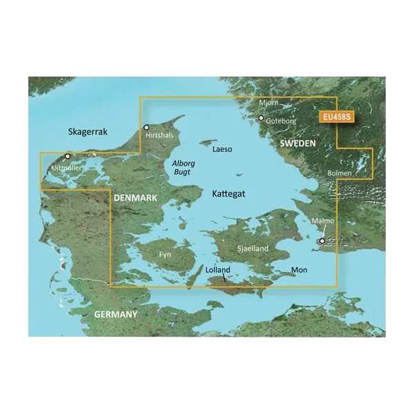
- Coverage Area: Continuous charting from Göteborg and Malmö (Sweden) through Danish waters including Fyn, with northern access to Hirtshals
Data Insights
Navigation accuracy improvements reach 30% compared to previous Garmin charting models, resulting from enhanced Navionics integration and updated bathymetric survey data. The chart card covers approximately 250 nautical miles of primary navigation routes, encompassing major Swedish coastal passages, the Kattegat strait, the Little Belt, and the Great Belt—regions where precise depth and route data directly impact fuel efficiency and safety. Real-time depth range visualization eliminates guesswork when planning passage through narrow channels or anchorage approaches common throughout the Baltisøen region.
Usage Instructions
Insert the microSD/SD card into any compatible Garmin chartplotter or marine GPS device. The chart data loads automatically upon device startup. Activate Auto Guidance to set desired draft and overhead clearance, then allow the device to calculate safe corridors through the coverage area. Periodically check the Garmin website for chart updates addressing new surveys, seasonal changes, or hazard corrections relevant to your cruising grounds.
Design & Material
The VEU458S card employs a compact, standard microSD/SD form factor that integrates seamlessly into Garmin's plotter lineup without requiring external adapters. Construction prioritizes both data integrity and reliability in marine salt-air environments through careful material selection and protective sealing.
- Durable microSD/SD Card Construction: Resistant to moisture, salt spray, and thermal cycling typical of offshore use
- High-Resolution Vector Graphics: Delivers crisp chart rendering without pixelation across the full zoom range from 500-mile views to 50-meter detail
- Integrated Garmin/Navionics Database: Combines decades of charting expertise into a single unified data layer
- Waterproof Housing: External card sleeve protects against spray and accidental submersion before insertion
- Plug-and-Play Compatibility: Works with all Garmin GPSMAP, echoMAP, and Striker series devices without configuration
- Real-Time Update Support: Firmware updates add corrected depths, new obstacles, and seasonal hazard alerts
Final Verdict
Navigating Sweden's and Denmark's complex coastal waters demands charts that reflect actual bottom structure and safe passage routes. The Garmin Göteborg to Fyn BlueChart g3 Vision provides exactly this level of detail in a reliable format that integrates with existing Garmin hardware. Cruisers planning passages through the Kattegat, anglers targeting Baltic structure, and commercial operators benefiting from improved route efficiency will recognize immediate value. Order the VEU458S now to upgrade your navigational capability for waters where precision determines both safety and success.


