


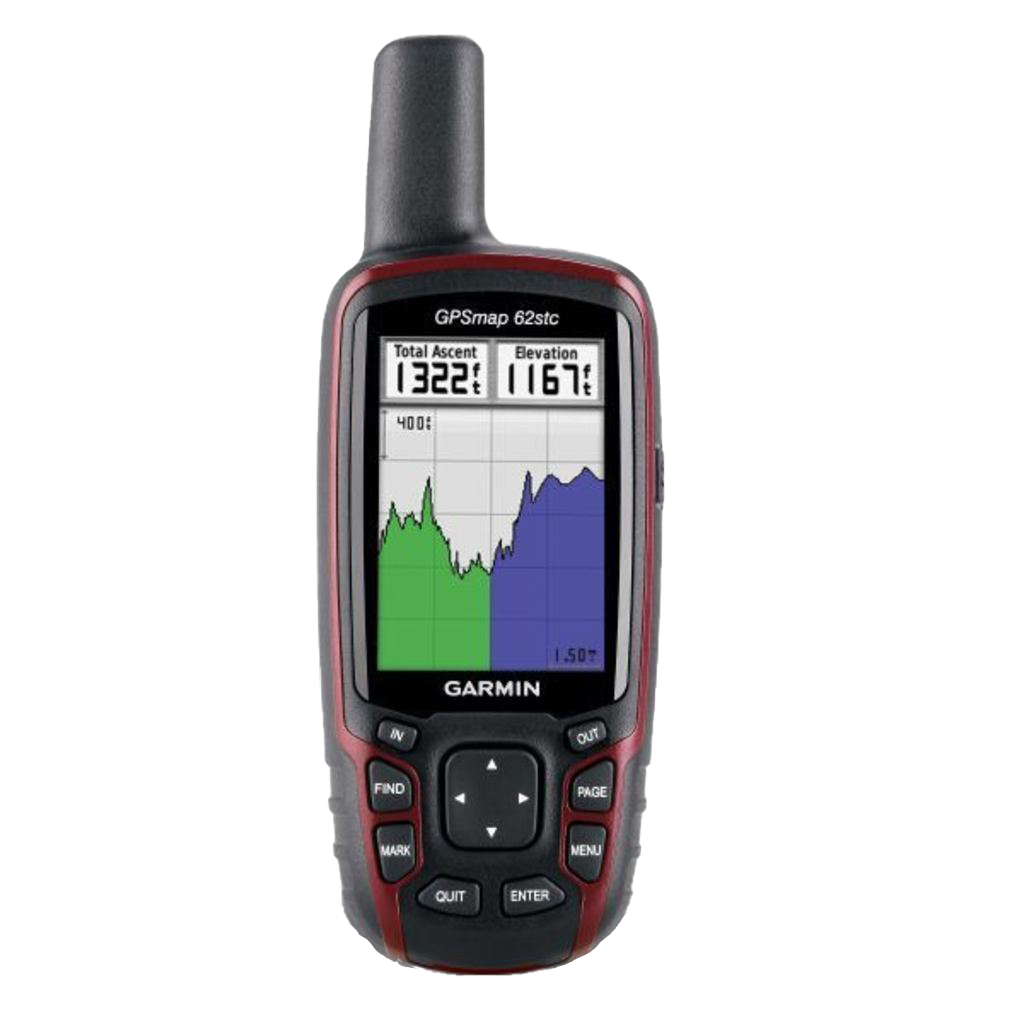
Garmin GPSMAP 62stc, Handheld Outdoor/Trail GPS with TOPO Maps (Garmin Certified Refurbished)
Garmin GPSMAP 62stc, Handheld Outdoor/Trail GPS with TOPO Maps (Garmin Certified Refurbished)
Model Number: 010-N0868-21
Out of stock
 WhatsApp
 SMS - Text us!
 Email Us!
 Help Desk

Tech Specs
Garmin GPSMAP 62stc Handheld GPS with TOPO Maps and 5MP Camera
Introduction
The Garmin GPSMAP 62stc is a rugged handheld GPS device built for serious outdoor navigation. This certified refurbished unit combines preloaded topographic maps with a high-sensitivity satellite receiver, making it reliable for hiking, geocaching, trail navigation, and backcountry exploration where precision and durability matter most. The integration of mapping technology, altimetry data, and geotagged photography gives you comprehensive tools to track your route, understand terrain, and document your journey—all in a device engineered to handle weather exposure and challenging conditions.
Key Features
- Preloaded TOPO U.S. 100K Maps covering national parks, forests, trails, and entire continental United States
- 20-hour battery life on two AA alkaline batteries, supporting extended backcountry trips without recharging
- 3-axis tilt-compensated digital compass providing accurate headings even when the device is held at angles
- Barometric altimeter tracking elevation changes with 100-meter resolution for weather monitoring and terrain assessment
- 5-megapixel autofocus camera with geotagging capability to automatically embed location data into photos
- Quad Helix antenna with high-sensitivity GPS receiver for faster signal acquisition in dense forest cover and deep canyons
- 3.5 GB onboard memory for additional map downloads and route storage
- IPX7 water-resistance rating protecting against splashes and temporary immersion
Data Insights
The GPSMAP 62stc performs consistently across demanding environments. Its high-sensitivity receiver reduces time-to-first-fix compared to standard GPS units, critical when navigating through tree canopy or between tall buildings. The barometric altimeter provides elevation data independent of satellite signals, ensuring altitude tracking remains continuous even when GPS signal weakens. At 20 hours of operation on standard AA batteries, the device delivers substantially longer field time than many competing models, reducing the need to carry spare battery packs on day hikes and multi-day trips.
Usage Instructions
Power on the device and allow it several seconds to acquire satellite signals—faster acquisition occurs in open terrain. Download the preloaded TOPO maps to identify trails, peaks, and water sources relevant to your planned route. Use the directional pad to navigate menus and access compass headings for bearing-based navigation. To mark waypoints, press the Mark button at key locations; these saved points can later be used to plot return routes or shared with other compatible Garmin devices. Utilize the altimeter display to monitor elevation gain and descent throughout your hike.
Design and Material
The GPSMAP 62stc balances durability with portability, featuring a rugged handheld form factor weighing approximately 230 grams—light enough for day-long carrying but substantial enough to feel solid in harsh conditions. The housing incorporates reinforced corners and protective bumpers to absorb impacts from falls or rocky terrain. The 2.6-inch monochrome display provides crisp readability in direct sunlight without the power drain of color screens, while the 8-button interface enables quick access to core functions without diving into menus.
- Reinforced casing constructed to absorb impacts and vibration from rough handling and falls
- Slip-resistant rubberized grip ensuring secure hold during wet conditions or extended field use
- Raised bezel protecting the display screen from contact damage and scratches
- Large tactile buttons designed for operation while wearing gloves or cold-weather mitigation gear
- Integrated antenna extending from the top for optimal satellite reception without external mounting
- Compact footprint at approximately 5.8 inches tall, fitting comfortably in cargo pockets or hip belt holsters
Final Verdict
The Garmin GPSMAP 62stc delivers proven navigation performance in a proven form factor. For hikers who demand reliable wayfinding without complexity, geocachers requiring accurate positioning data, and wilderness explorers who value battery longevity and durability over screen brightness, this device remains a dependable choice. This certified refurbished model offers the same performance specifications as new units at a lower price point, making it an accessible entry into precision outdoor navigation. Purchase the Garmin GPSMAP 62stc today and build confidence into every trail you explore.
In The Box
- GPSMAP 62stc
- Carabiner clip
- 2 AA NiMH batteries
- Battery charger
- USB cable
- Manual
Do you have an old GPS unit lying around? The GPS Nation Trade In and Up program is a great way to trade in your old and used GPS for credit towards a new GPS. The choice is entirely yours! We’ve made the process simple and streamlined. Follow these simple steps, and you will be on your way to receiving credit towards your brand new GPS!
1. Get a quote
To get your free quote, provide your GPS type, manufacturer, model, and condition. Within 24 hours, you will receive a quote for the trade-in value of your current product. The GPS trade-in/trade-up form is at the bottom of this page.
2. Ship your product(s) for trade
After accepting our offer, pack your product(s) safely and ship them to us using the pre-paid shipping label provided to you. We will provide a confirmation email when your trade-in arrives at our warehouse. You have 30 days from the date you complete your on-line trade to ship the product to GPS Nation.
3. Make your purchase
Once we receive your product at our warehouse and we validate the stated condition, we will send you a confirmation email. If you elect to receive credit towards a new GPS at gpsnation.com, your store credit will be issued, and you are free to make your purchase.
Manual & Warranty
 Garmin Warranty
Reviews
Ask a Question
Tech Specs
Garmin GPSMAP 62stc Handheld GPS with TOPO Maps and 5MP Camera
Introduction
The Garmin GPSMAP 62stc is a rugged handheld GPS device built for serious outdoor navigation. This certified refurbished unit combines preloaded topographic maps with a high-sensitivity satellite receiver, making it reliable for hiking, geocaching, trail navigation, and backcountry exploration where precision and durability matter most. The integration of mapping technology, altimetry data, and geotagged photography gives you comprehensive tools to track your route, understand terrain, and document your journey—all in a device engineered to handle weather exposure and challenging conditions.
Key Features
- Preloaded TOPO U.S. 100K Maps covering national parks, forests, trails, and entire continental United States
- 20-hour battery life on two AA alkaline batteries, supporting extended backcountry trips without recharging
- 3-axis tilt-compensated digital compass providing accurate headings even when the device is held at angles
- Barometric altimeter tracking elevation changes with 100-meter resolution for weather monitoring and terrain assessment
- 5-megapixel autofocus camera with geotagging capability to automatically embed location data into photos
- Quad Helix antenna with high-sensitivity GPS receiver for faster signal acquisition in dense forest cover and deep canyons
- 3.5 GB onboard memory for additional map downloads and route storage
- IPX7 water-resistance rating protecting against splashes and temporary immersion
Data Insights
The GPSMAP 62stc performs consistently across demanding environments. Its high-sensitivity receiver reduces time-to-first-fix compared to standard GPS units, critical when navigating through tree canopy or between tall buildings. The barometric altimeter provides elevation data independent of satellite signals, ensuring altitude tracking remains continuous even when GPS signal weakens. At 20 hours of operation on standard AA batteries, the device delivers substantially longer field time than many competing models, reducing the need to carry spare battery packs on day hikes and multi-day trips.
Usage Instructions
Power on the device and allow it several seconds to acquire satellite signals—faster acquisition occurs in open terrain. Download the preloaded TOPO maps to identify trails, peaks, and water sources relevant to your planned route. Use the directional pad to navigate menus and access compass headings for bearing-based navigation. To mark waypoints, press the Mark button at key locations; these saved points can later be used to plot return routes or shared with other compatible Garmin devices. Utilize the altimeter display to monitor elevation gain and descent throughout your hike.
Design and Material
The GPSMAP 62stc balances durability with portability, featuring a rugged handheld form factor weighing approximately 230 grams—light enough for day-long carrying but substantial enough to feel solid in harsh conditions. The housing incorporates reinforced corners and protective bumpers to absorb impacts from falls or rocky terrain. The 2.6-inch monochrome display provides crisp readability in direct sunlight without the power drain of color screens, while the 8-button interface enables quick access to core functions without diving into menus.
- Reinforced casing constructed to absorb impacts and vibration from rough handling and falls
- Slip-resistant rubberized grip ensuring secure hold during wet conditions or extended field use
- Raised bezel protecting the display screen from contact damage and scratches
- Large tactile buttons designed for operation while wearing gloves or cold-weather mitigation gear
- Integrated antenna extending from the top for optimal satellite reception without external mounting
- Compact footprint at approximately 5.8 inches tall, fitting comfortably in cargo pockets or hip belt holsters
Final Verdict
The Garmin GPSMAP 62stc delivers proven navigation performance in a proven form factor. For hikers who demand reliable wayfinding without complexity, geocachers requiring accurate positioning data, and wilderness explorers who value battery longevity and durability over screen brightness, this device remains a dependable choice. This certified refurbished model offers the same performance specifications as new units at a lower price point, making it an accessible entry into precision outdoor navigation. Purchase the Garmin GPSMAP 62stc today and build confidence into every trail you explore.
In The Box
- GPSMAP 62stc
- Carabiner clip
- 2 AA NiMH batteries
- Battery charger
- USB cable
- Manual
Trade-In
Do you have an old GPS unit lying around? The GPS Nation Trade In and Up program is a great way to trade in your old and used GPS for credit towards a new GPS. The choice is entirely yours! We’ve made the process simple and streamlined. Follow these simple steps, and you will be on your way to receiving credit towards your brand new GPS!
1. Get a quote
To get your free quote, provide your GPS type, manufacturer, model, and condition. Within 24 hours, you will receive a quote for the trade-in value of your current product. The GPS trade-in/trade-up form is at the bottom of this page.
2. Ship your product(s) for trade
After accepting our offer, pack your product(s) safely and ship them to us using the pre-paid shipping label provided to you. We will provide a confirmation email when your trade-in arrives at our warehouse. You have 30 days from the date you complete your on-line trade to ship the product to GPS Nation.
3. Make your purchase
Once we receive your product at our warehouse and we validate the stated condition, we will send you a confirmation email. If you elect to receive credit towards a new GPS at gpsnation.com, your store credit will be issued, and you are free to make your purchase.
Manual & Warranty
Overview
Garmin GPSMAP 62stc Handheld GPS with TOPO Maps and 5MP Camera
Introduction
The Garmin GPSMAP 62stc is a rugged handheld GPS device built for serious outdoor navigation. This certified refurbished unit combines preloaded topographic maps with a high-sensitivity satellite receiver, making it reliable for hiking, geocaching, trail navigation, and backcountry exploration where precision and durability matter most. The integration of mapping technology, altimetry data, and geotagged photography gives you comprehensive tools to track your route, understand terrain, and document your journey—all in a device engineered to handle weather exposure and challenging conditions.
Key Features
- Preloaded TOPO U.S. 100K Maps covering national parks, forests, trails, and entire continental United States
- 20-hour battery life on two AA alkaline batteries, supporting extended backcountry trips without recharging
- 3-axis tilt-compensated digital compass providing accurate headings even when the device is held at angles
- Barometric altimeter tracking elevation changes with 100-meter resolution for weather monitoring and terrain assessment
- 5-megapixel autofocus camera with geotagging capability to automatically embed location data into photos
- Quad Helix antenna with high-sensitivity GPS receiver for faster signal acquisition in dense forest cover and deep canyons
- 3.5 GB onboard memory for additional map downloads and route storage
- IPX7 water-resistance rating protecting against splashes and temporary immersion
Data Insights
The GPSMAP 62stc performs consistently across demanding environments. Its high-sensitivity receiver reduces time-to-first-fix compared to standard GPS units, critical when navigating through tree canopy or between tall buildings. The barometric altimeter provides elevation data independent of satellite signals, ensuring altitude tracking remains continuous even when GPS signal weakens. At 20 hours of operation on standard AA batteries, the device delivers substantially longer field time than many competing models, reducing the need to carry spare battery packs on day hikes and multi-day trips.
Usage Instructions
Power on the device and allow it several seconds to acquire satellite signals—faster acquisition occurs in open terrain. Download the preloaded TOPO maps to identify trails, peaks, and water sources relevant to your planned route. Use the directional pad to navigate menus and access compass headings for bearing-based navigation. To mark waypoints, press the Mark button at key locations; these saved points can later be used to plot return routes or shared with other compatible Garmin devices. Utilize the altimeter display to monitor elevation gain and descent throughout your hike.
Design and Material
The GPSMAP 62stc balances durability with portability, featuring a rugged handheld form factor weighing approximately 230 grams—light enough for day-long carrying but substantial enough to feel solid in harsh conditions. The housing incorporates reinforced corners and protective bumpers to absorb impacts from falls or rocky terrain. The 2.6-inch monochrome display provides crisp readability in direct sunlight without the power drain of color screens, while the 8-button interface enables quick access to core functions without diving into menus.
- Reinforced casing constructed to absorb impacts and vibration from rough handling and falls
- Slip-resistant rubberized grip ensuring secure hold during wet conditions or extended field use
- Raised bezel protecting the display screen from contact damage and scratches
- Large tactile buttons designed for operation while wearing gloves or cold-weather mitigation gear
- Integrated antenna extending from the top for optimal satellite reception without external mounting
- Compact footprint at approximately 5.8 inches tall, fitting comfortably in cargo pockets or hip belt holsters
Final Verdict
The Garmin GPSMAP 62stc delivers proven navigation performance in a proven form factor. For hikers who demand reliable wayfinding without complexity, geocachers requiring accurate positioning data, and wilderness explorers who value battery longevity and durability over screen brightness, this device remains a dependable choice. This certified refurbished model offers the same performance specifications as new units at a lower price point, making it an accessible entry into precision outdoor navigation. Purchase the Garmin GPSMAP 62stc today and build confidence into every trail you explore.


