


 WhatsApp
 SMS - Text us!
 Email Us!
 Help Desk
- GPSMAP 64st
- Preloaded TOPO U.S. 100K maps
- 1-year BirdsEye Satellite Imagery subscription
- Carabiner clip
- USB cable
- Manual
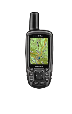
Garmin GPSMAP 64st, Handheld Outdoor/Trail GPS with TOPO Maps (Garmin Certified Refurbished)
Garmin GPSMAP 64st, Handheld Outdoor/Trail GPS with TOPO Maps (Garmin Certified Refurbished)
Model Number: 010-N1199-20
Out of stock
Condition:
Garmin Certified Refurbished
This Garmin GPSMAP 64st, Handheld Outdoor/Trail GPS with TOPO Maps (Garmin Certified Refurbished) is expertly rebuilt to like-new condition by Garmin USA. Garmin Certified Refurbished devices offer a sustainable choice without compromising quality, durability, or reliability. Backed by a one-year Garmin warranty, and free 60-day returns from GPS Nation. This Garmin Certified Refurbished device provides peace of mind and exceptional value for conscious consumers seeking reliable performance.
Regular price
$296.99
Sale price
$296.99
Regular price
Unit price
per

Tech Specs
Garmin GPSMAP 64st Handheld GPS for Trail Navigation and Outdoor Exploration
Introduction
The Garmin GPSMAP 64st is a rugged handheld GPS unit built specifically for backcountry navigation, trail hiking, and outdoor exploration where terrain complexity and signal coverage demands a dedicated device. With dual satellite reception (GPS and GLONASS), a sunlight-readable 2.6-inch color display, and preloaded topographic mapping, this unit handles the navigation demands of serious hikers, geocachers, and wilderness adventurers where smartphones and casual navigation tools fall short.
Key Features
- 2.6-inch color display with high-contrast rendering—visible in direct sunlight without screen washout
- Dual GPS and GLONASS satellite reception delivers 20% better location accuracy than GPS alone
- 8 GB internal storage with microSD card expansion capability for unlimited map data
- Preloaded TOPO U.S. 100K maps covering the entire United States with contour lines and trail detail
- Battery life rated up to 16 hours on AA batteries, supporting multiple-day backcountry trips
- Satellite acquisition time of 1–2 minutes when operating outdoors with clear skyline
- IPX7 water-resistance rating handles immersion up to 1 meter for 30 minutes
- Barometric altimeter, 3-axis digital compass, and built-in weather tracking for real-time conditions
- Bluetooth and ANT+ wireless connectivity for pairing with compatible accessories and fitness devices
- Weighs 7.5 ounces with ergonomic grip scaled for extended handheld navigation
Data Insights
Location accuracy improves by up to 20% when GPS and GLONASS systems work in tandem, a meaningful advantage in steep terrain or dense forest canopy where single-system receivers struggle. The 16-hour battery endurance on standard AA batteries eliminates the charge-anxiety of long expeditions, and the dual-satellite architecture typically locks a position within 1–2 minutes of power-on in open sky, critical for time-sensitive navigation decisions on remote trails.
Usage Instructions
Charge or load fresh AA batteries before departure. Create waypoints and named routes on your planned trails using the TOPO map interface, zooming to review terrain contours and water crossings. Mark your starting point and set a return-to-start route as a safety backup. Store the device in a secured, accessible pocket to prevent loss or damage, and periodically reference bearing and altitude data to confirm your position against map features rather than relying entirely on screen coordinates.
Design & Material
The GPSMAP 64st combines impact-resistant exterior casing with an intuitive five-button control layout, prioritizing durability over complexity. Its form factor balances screen real estate with single-hand grip capability, and the rubberized exterior absorbs shock from pack impacts and brush contact typical of trail use.
- Reinforced plastic casing engineered to survive falls and rough handling in wilderness settings
- Ergonomic grip with textured rubber overlay reduces hand fatigue during multi-hour navigation sessions
- IPX7 water-resistance rating rated for rain exposure and creek crossing without sealed replacements
- Lightweight 7.5-ounce mass reduces load burden on long-distance hikes and backcountry treks
- Sunlight-readable LCD prevents glare-induced navigation errors in bright alpine or desert terrain
- Customizable data screens allow users to display altitude, compass heading, and distance metrics simultaneously
Final Verdict
The Garmin GPSMAP 64st solves the central problem of wilderness navigation—getting accurate position and terrain information where cellular networks and smartphone GPS fail—with proven hardware and comprehensive map coverage. If your adventures demand reliability over convenience, and you need a navigation tool that survives weather, terrain, and extended battery demands, the GPSMAP 64st delivers the accuracy, endurance, and durability that separate serious outdoor navigation from casual app-based alternatives. Make it your trusted navigation partner for trails where getting lost has real consequences.
In The Box
Do you have an old GPS unit lying around? The GPS Nation Trade In and Up program is a great way to trade in your old and used GPS for credit towards a new GPS. The choice is entirely yours! We’ve made the process simple and streamlined. Follow these simple steps, and you will be on your way to receiving credit towards your brand new GPS!
1. Get a quote
To get your free quote, provide your GPS type, manufacturer, model, and condition. Within 24 hours, you will receive a quote for the trade-in value of your current product. The GPS trade-in/trade-up form is at the bottom of this page.
2. Ship your product(s) for trade
After accepting our offer, pack your product(s) safely and ship them to us using the pre-paid shipping label provided to you. We will provide a confirmation email when your trade-in arrives at our warehouse. You have 30 days from the date you complete your on-line trade to ship the product to GPS Nation.
3. Make your purchase
Once we receive your product at our warehouse and we validate the stated condition, we will send you a confirmation email. If you elect to receive credit towards a new GPS at gpsnation.com, your store credit will be issued, and you are free to make your purchase.
Manual & Warranty
 Garmin Warranty
Reviews
Ask a Question
Tech Specs
Garmin GPSMAP 64st Handheld GPS for Trail Navigation and Outdoor Exploration
Introduction
The Garmin GPSMAP 64st is a rugged handheld GPS unit built specifically for backcountry navigation, trail hiking, and outdoor exploration where terrain complexity and signal coverage demands a dedicated device. With dual satellite reception (GPS and GLONASS), a sunlight-readable 2.6-inch color display, and preloaded topographic mapping, this unit handles the navigation demands of serious hikers, geocachers, and wilderness adventurers where smartphones and casual navigation tools fall short.
Key Features
- 2.6-inch color display with high-contrast rendering—visible in direct sunlight without screen washout
- Dual GPS and GLONASS satellite reception delivers 20% better location accuracy than GPS alone
- 8 GB internal storage with microSD card expansion capability for unlimited map data
- Preloaded TOPO U.S. 100K maps covering the entire United States with contour lines and trail detail
- Battery life rated up to 16 hours on AA batteries, supporting multiple-day backcountry trips
- Satellite acquisition time of 1–2 minutes when operating outdoors with clear skyline
- IPX7 water-resistance rating handles immersion up to 1 meter for 30 minutes
- Barometric altimeter, 3-axis digital compass, and built-in weather tracking for real-time conditions
- Bluetooth and ANT+ wireless connectivity for pairing with compatible accessories and fitness devices
- Weighs 7.5 ounces with ergonomic grip scaled for extended handheld navigation
Data Insights
Location accuracy improves by up to 20% when GPS and GLONASS systems work in tandem, a meaningful advantage in steep terrain or dense forest canopy where single-system receivers struggle. The 16-hour battery endurance on standard AA batteries eliminates the charge-anxiety of long expeditions, and the dual-satellite architecture typically locks a position within 1–2 minutes of power-on in open sky, critical for time-sensitive navigation decisions on remote trails.
Usage Instructions
Charge or load fresh AA batteries before departure. Create waypoints and named routes on your planned trails using the TOPO map interface, zooming to review terrain contours and water crossings. Mark your starting point and set a return-to-start route as a safety backup. Store the device in a secured, accessible pocket to prevent loss or damage, and periodically reference bearing and altitude data to confirm your position against map features rather than relying entirely on screen coordinates.
Design & Material
The GPSMAP 64st combines impact-resistant exterior casing with an intuitive five-button control layout, prioritizing durability over complexity. Its form factor balances screen real estate with single-hand grip capability, and the rubberized exterior absorbs shock from pack impacts and brush contact typical of trail use.
- Reinforced plastic casing engineered to survive falls and rough handling in wilderness settings
- Ergonomic grip with textured rubber overlay reduces hand fatigue during multi-hour navigation sessions
- IPX7 water-resistance rating rated for rain exposure and creek crossing without sealed replacements
- Lightweight 7.5-ounce mass reduces load burden on long-distance hikes and backcountry treks
- Sunlight-readable LCD prevents glare-induced navigation errors in bright alpine or desert terrain
- Customizable data screens allow users to display altitude, compass heading, and distance metrics simultaneously
Final Verdict
The Garmin GPSMAP 64st solves the central problem of wilderness navigation—getting accurate position and terrain information where cellular networks and smartphone GPS fail—with proven hardware and comprehensive map coverage. If your adventures demand reliability over convenience, and you need a navigation tool that survives weather, terrain, and extended battery demands, the GPSMAP 64st delivers the accuracy, endurance, and durability that separate serious outdoor navigation from casual app-based alternatives. Make it your trusted navigation partner for trails where getting lost has real consequences.
In The Box
- GPSMAP 64st
- Preloaded TOPO U.S. 100K maps
- 1-year BirdsEye Satellite Imagery subscription
- Carabiner clip
- USB cable
- Manual
Trade-In
Do you have an old GPS unit lying around? The GPS Nation Trade In and Up program is a great way to trade in your old and used GPS for credit towards a new GPS. The choice is entirely yours! We’ve made the process simple and streamlined. Follow these simple steps, and you will be on your way to receiving credit towards your brand new GPS!
1. Get a quote
To get your free quote, provide your GPS type, manufacturer, model, and condition. Within 24 hours, you will receive a quote for the trade-in value of your current product. The GPS trade-in/trade-up form is at the bottom of this page.
2. Ship your product(s) for trade
After accepting our offer, pack your product(s) safely and ship them to us using the pre-paid shipping label provided to you. We will provide a confirmation email when your trade-in arrives at our warehouse. You have 30 days from the date you complete your on-line trade to ship the product to GPS Nation.
3. Make your purchase
Once we receive your product at our warehouse and we validate the stated condition, we will send you a confirmation email. If you elect to receive credit towards a new GPS at gpsnation.com, your store credit will be issued, and you are free to make your purchase.
Manual & Warranty
Overview
Garmin GPSMAP 64st Handheld GPS for Trail Navigation and Outdoor Exploration
Introduction
The Garmin GPSMAP 64st is a rugged handheld GPS unit built specifically for backcountry navigation, trail hiking, and outdoor exploration where terrain complexity and signal coverage demands a dedicated device. With dual satellite reception (GPS and GLONASS), a sunlight-readable 2.6-inch color display, and preloaded topographic mapping, this unit handles the navigation demands of serious hikers, geocachers, and wilderness adventurers where smartphones and casual navigation tools fall short.
Key Features
- 2.6-inch color display with high-contrast rendering—visible in direct sunlight without screen washout
- Dual GPS and GLONASS satellite reception delivers 20% better location accuracy than GPS alone
- 8 GB internal storage with microSD card expansion capability for unlimited map data
- Preloaded TOPO U.S. 100K maps covering the entire United States with contour lines and trail detail
- Battery life rated up to 16 hours on AA batteries, supporting multiple-day backcountry trips
- Satellite acquisition time of 1–2 minutes when operating outdoors with clear skyline
- IPX7 water-resistance rating handles immersion up to 1 meter for 30 minutes
- Barometric altimeter, 3-axis digital compass, and built-in weather tracking for real-time conditions
- Bluetooth and ANT+ wireless connectivity for pairing with compatible accessories and fitness devices
- Weighs 7.5 ounces with ergonomic grip scaled for extended handheld navigation
Data Insights
Location accuracy improves by up to 20% when GPS and GLONASS systems work in tandem, a meaningful advantage in steep terrain or dense forest canopy where single-system receivers struggle. The 16-hour battery endurance on standard AA batteries eliminates the charge-anxiety of long expeditions, and the dual-satellite architecture typically locks a position within 1–2 minutes of power-on in open sky, critical for time-sensitive navigation decisions on remote trails.
Usage Instructions
Charge or load fresh AA batteries before departure. Create waypoints and named routes on your planned trails using the TOPO map interface, zooming to review terrain contours and water crossings. Mark your starting point and set a return-to-start route as a safety backup. Store the device in a secured, accessible pocket to prevent loss or damage, and periodically reference bearing and altitude data to confirm your position against map features rather than relying entirely on screen coordinates.
Design & Material
The GPSMAP 64st combines impact-resistant exterior casing with an intuitive five-button control layout, prioritizing durability over complexity. Its form factor balances screen real estate with single-hand grip capability, and the rubberized exterior absorbs shock from pack impacts and brush contact typical of trail use.
- Reinforced plastic casing engineered to survive falls and rough handling in wilderness settings
- Ergonomic grip with textured rubber overlay reduces hand fatigue during multi-hour navigation sessions
- IPX7 water-resistance rating rated for rain exposure and creek crossing without sealed replacements
- Lightweight 7.5-ounce mass reduces load burden on long-distance hikes and backcountry treks
- Sunlight-readable LCD prevents glare-induced navigation errors in bright alpine or desert terrain
- Customizable data screens allow users to display altitude, compass heading, and distance metrics simultaneously
Final Verdict
The Garmin GPSMAP 64st solves the central problem of wilderness navigation—getting accurate position and terrain information where cellular networks and smartphone GPS fail—with proven hardware and comprehensive map coverage. If your adventures demand reliability over convenience, and you need a navigation tool that survives weather, terrain, and extended battery demands, the GPSMAP 64st delivers the accuracy, endurance, and durability that separate serious outdoor navigation from casual app-based alternatives. Make it your trusted navigation partner for trails where getting lost has real consequences.


