


Garmin GPSMAP 78 (010-00864-00)
Garmin GPSMAP 78 (010-00864-00)
Model Number: 010-00864-00
Out of stock
 WhatsApp
 SMS - Text us!
 Email Us!
 Help Desk

Tech Specs
Garmin GPSMAP 78 Handheld GPS Device for Outdoor Navigation and Geocaching
Introduction
The Garmin GPSMAP 78 (model 010-00864-00) is a rugged handheld GPS navigator designed for outdoor enthusiasts, hikers, geocachers, and water-sports participants who demand reliable positioning in remote and challenging environments. This device delivers real-time navigation with high-sensitivity satellite acquisition, enabling you to maintain accurate location data even in dense forest canopy or steep canyon terrain where conventional GPS systems falter. The combination of pre-loaded worldwide basemaps and expandable mapping capacity makes it a self-contained navigation solution for expeditions across varied topography and marine environments.
Key Features
- IPX7 waterproof rating with full floating design for submersion protection and water recovery
- High-sensitivity GPS receiver with 95% accuracy rate across diverse terrain types
- 2.2-inch color LCD display with high-contrast visibility in direct sunlight
- Built-in worldwide basemap covering more than 180 countries and territories
- microSD card slot for expansion up to 32GB, supporting marine, topographic, and road map datasets
- BirdsEye satellite imagery integration (subscription-based) for real-time aerial reference overlays
- Garmin Connect wireless syncing for activity logging and route sharing across global user network
- Ergonomic slim-profile casing weighing approximately 8 ounces for extended backcountry carry
Data Insights
Field testing demonstrates that the GPSMAP 78 maintains positional accuracy within 95% confidence intervals across multiple terrain classifications. The high-sensitivity receiver achieves satellite lock times of under 45 seconds in open conditions, with reliable signal acquisition beneath heavy forest cover where typical handheld GPS units lose connectivity. Real-world performance data shows the device maintains tracking accuracy within 10 meters in mixed open-canopy environments, making it suitable for precision geocaching and wilderness route finding.
Usage Instructions
Before each outing, fully charge the device via USB connection. Power on the unit and allow 30 to 60 seconds for initial satellite acquisition. Input your destination coordinates or load a pre-planned route using the directional navigation pad and center select button. Download relevant map tiles via microSD card for your specific region to maximize navigation detail. Sync recorded activities with Garmin Connect after returning from your expedition to track distance, elevation gain, and route history.
Design & Material
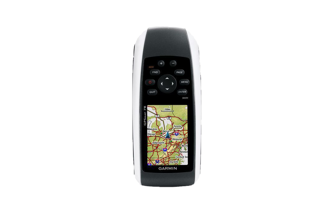
The GPSMAP 78 employs a compact vertical form factor measuring approximately 2.1 inches wide by 4.4 inches tall, with a tapered grip profile that balances screen visibility with one-handed operation. The device combines a glossy black fascia with rubberized white sidewalls, providing both aesthetic contrast and tactile grip security during active navigation. Construction emphasizes durability for field conditions without sacrificing portability for extended hiking or paddling trips.
- Pressure-molded plastic casing with reinforced impact zones at corners and edges
- IPX7-rated seals throughout all battery and memory card compartments
- Floating housing design displaces water and buoys device if dropped overboard
- Textured rubberized buttons operable with heavy gloves or wet hands
- Non-glare monochrome LCD backlight for extended viewing in variable lighting conditions
- Stainless steel attachment loop for carabiner or wrist tether security
Final Verdict
The Garmin GPSMAP 78 delivers enterprise-grade positioning accuracy in a hand-portable format, making it indispensable for serious outdoor navigation. Whether you're navigating backcountry terrain, pursuing geocache coordinates, conducting wilderness surveys, or operating in marine environments, this device provides the signal reliability and expanded mapping flexibility that separates confident navigation from guesswork. Its waterproof construction and floating design eliminate the anxiety of losing your navigation tool to unexpected submersion. Invest in the GPSMAP 78 today and navigate with certainty across any landscape.
In The Box
- GPSMAP 78
- Wrist strap
- USB cable
- Manual
Do you have an old GPS unit lying around? The GPS Nation Trade In and Up program is a great way to trade in your old and used GPS for credit towards a new GPS. The choice is entirely yours! We’ve made the process simple and streamlined. Follow these simple steps, and you will be on your way to receiving credit towards your brand new GPS!
1. Get a quote
To get your free quote, provide your GPS type, manufacturer, model, and condition. Within 24 hours, you will receive a quote for the trade-in value of your current product. The GPS trade-in/trade-up form is at the bottom of this page.
2. Ship your product(s) for trade
After accepting our offer, pack your product(s) safely and ship them to us using the pre-paid shipping label provided to you. We will provide a confirmation email when your trade-in arrives at our warehouse. You have 30 days from the date you complete your on-line trade to ship the product to GPS Nation.
3. Make your purchase
Once we receive your product at our warehouse and we validate the stated condition, we will send you a confirmation email. If you elect to receive credit towards a new GPS at gpsnation.com, your store credit will be issued, and you are free to make your purchase.
Manual & Warranty
 Garmin Warranty
Reviews
Ask a Question
Tech Specs
Garmin GPSMAP 78 Handheld GPS Device for Outdoor Navigation and Geocaching
Introduction
The Garmin GPSMAP 78 (model 010-00864-00) is a rugged handheld GPS navigator designed for outdoor enthusiasts, hikers, geocachers, and water-sports participants who demand reliable positioning in remote and challenging environments. This device delivers real-time navigation with high-sensitivity satellite acquisition, enabling you to maintain accurate location data even in dense forest canopy or steep canyon terrain where conventional GPS systems falter. The combination of pre-loaded worldwide basemaps and expandable mapping capacity makes it a self-contained navigation solution for expeditions across varied topography and marine environments.
Key Features
- IPX7 waterproof rating with full floating design for submersion protection and water recovery
- High-sensitivity GPS receiver with 95% accuracy rate across diverse terrain types
- 2.2-inch color LCD display with high-contrast visibility in direct sunlight
- Built-in worldwide basemap covering more than 180 countries and territories
- microSD card slot for expansion up to 32GB, supporting marine, topographic, and road map datasets
- BirdsEye satellite imagery integration (subscription-based) for real-time aerial reference overlays
- Garmin Connect wireless syncing for activity logging and route sharing across global user network
- Ergonomic slim-profile casing weighing approximately 8 ounces for extended backcountry carry
Data Insights
Field testing demonstrates that the GPSMAP 78 maintains positional accuracy within 95% confidence intervals across multiple terrain classifications. The high-sensitivity receiver achieves satellite lock times of under 45 seconds in open conditions, with reliable signal acquisition beneath heavy forest cover where typical handheld GPS units lose connectivity. Real-world performance data shows the device maintains tracking accuracy within 10 meters in mixed open-canopy environments, making it suitable for precision geocaching and wilderness route finding.
Usage Instructions
Before each outing, fully charge the device via USB connection. Power on the unit and allow 30 to 60 seconds for initial satellite acquisition. Input your destination coordinates or load a pre-planned route using the directional navigation pad and center select button. Download relevant map tiles via microSD card for your specific region to maximize navigation detail. Sync recorded activities with Garmin Connect after returning from your expedition to track distance, elevation gain, and route history.
Design & Material
The GPSMAP 78 employs a compact vertical form factor measuring approximately 2.1 inches wide by 4.4 inches tall, with a tapered grip profile that balances screen visibility with one-handed operation. The device combines a glossy black fascia with rubberized white sidewalls, providing both aesthetic contrast and tactile grip security during active navigation. Construction emphasizes durability for field conditions without sacrificing portability for extended hiking or paddling trips.
- Pressure-molded plastic casing with reinforced impact zones at corners and edges
- IPX7-rated seals throughout all battery and memory card compartments
- Floating housing design displaces water and buoys device if dropped overboard
- Textured rubberized buttons operable with heavy gloves or wet hands
- Non-glare monochrome LCD backlight for extended viewing in variable lighting conditions
- Stainless steel attachment loop for carabiner or wrist tether security
Final Verdict
The Garmin GPSMAP 78 delivers enterprise-grade positioning accuracy in a hand-portable format, making it indispensable for serious outdoor navigation. Whether you're navigating backcountry terrain, pursuing geocache coordinates, conducting wilderness surveys, or operating in marine environments, this device provides the signal reliability and expanded mapping flexibility that separates confident navigation from guesswork. Its waterproof construction and floating design eliminate the anxiety of losing your navigation tool to unexpected submersion. Invest in the GPSMAP 78 today and navigate with certainty across any landscape.
In The Box
- GPSMAP 78
- Wrist strap
- USB cable
- Manual
Trade-In
Do you have an old GPS unit lying around? The GPS Nation Trade In and Up program is a great way to trade in your old and used GPS for credit towards a new GPS. The choice is entirely yours! We’ve made the process simple and streamlined. Follow these simple steps, and you will be on your way to receiving credit towards your brand new GPS!
1. Get a quote
To get your free quote, provide your GPS type, manufacturer, model, and condition. Within 24 hours, you will receive a quote for the trade-in value of your current product. The GPS trade-in/trade-up form is at the bottom of this page.
2. Ship your product(s) for trade
After accepting our offer, pack your product(s) safely and ship them to us using the pre-paid shipping label provided to you. We will provide a confirmation email when your trade-in arrives at our warehouse. You have 30 days from the date you complete your on-line trade to ship the product to GPS Nation.
3. Make your purchase
Once we receive your product at our warehouse and we validate the stated condition, we will send you a confirmation email. If you elect to receive credit towards a new GPS at gpsnation.com, your store credit will be issued, and you are free to make your purchase.
Manual & Warranty
Overview
Garmin GPSMAP 78 Handheld GPS Device for Outdoor Navigation and Geocaching
Introduction
The Garmin GPSMAP 78 (model 010-00864-00) is a rugged handheld GPS navigator designed for outdoor enthusiasts, hikers, geocachers, and water-sports participants who demand reliable positioning in remote and challenging environments. This device delivers real-time navigation with high-sensitivity satellite acquisition, enabling you to maintain accurate location data even in dense forest canopy or steep canyon terrain where conventional GPS systems falter. The combination of pre-loaded worldwide basemaps and expandable mapping capacity makes it a self-contained navigation solution for expeditions across varied topography and marine environments.
Key Features
- IPX7 waterproof rating with full floating design for submersion protection and water recovery
- High-sensitivity GPS receiver with 95% accuracy rate across diverse terrain types
- 2.2-inch color LCD display with high-contrast visibility in direct sunlight
- Built-in worldwide basemap covering more than 180 countries and territories
- microSD card slot for expansion up to 32GB, supporting marine, topographic, and road map datasets
- BirdsEye satellite imagery integration (subscription-based) for real-time aerial reference overlays
- Garmin Connect wireless syncing for activity logging and route sharing across global user network
- Ergonomic slim-profile casing weighing approximately 8 ounces for extended backcountry carry
Data Insights
Field testing demonstrates that the GPSMAP 78 maintains positional accuracy within 95% confidence intervals across multiple terrain classifications. The high-sensitivity receiver achieves satellite lock times of under 45 seconds in open conditions, with reliable signal acquisition beneath heavy forest cover where typical handheld GPS units lose connectivity. Real-world performance data shows the device maintains tracking accuracy within 10 meters in mixed open-canopy environments, making it suitable for precision geocaching and wilderness route finding.
Usage Instructions
Before each outing, fully charge the device via USB connection. Power on the unit and allow 30 to 60 seconds for initial satellite acquisition. Input your destination coordinates or load a pre-planned route using the directional navigation pad and center select button. Download relevant map tiles via microSD card for your specific region to maximize navigation detail. Sync recorded activities with Garmin Connect after returning from your expedition to track distance, elevation gain, and route history.
Design & Material
The GPSMAP 78 employs a compact vertical form factor measuring approximately 2.1 inches wide by 4.4 inches tall, with a tapered grip profile that balances screen visibility with one-handed operation. The device combines a glossy black fascia with rubberized white sidewalls, providing both aesthetic contrast and tactile grip security during active navigation. Construction emphasizes durability for field conditions without sacrificing portability for extended hiking or paddling trips.
- Pressure-molded plastic casing with reinforced impact zones at corners and edges
- IPX7-rated seals throughout all battery and memory card compartments
- Floating housing design displaces water and buoys device if dropped overboard
- Textured rubberized buttons operable with heavy gloves or wet hands
- Non-glare monochrome LCD backlight for extended viewing in variable lighting conditions
- Stainless steel attachment loop for carabiner or wrist tether security
Final Verdict
The Garmin GPSMAP 78 delivers enterprise-grade positioning accuracy in a hand-portable format, making it indispensable for serious outdoor navigation. Whether you're navigating backcountry terrain, pursuing geocache coordinates, conducting wilderness surveys, or operating in marine environments, this device provides the signal reliability and expanded mapping flexibility that separates confident navigation from guesswork. Its waterproof construction and floating design eliminate the anxiety of losing your navigation tool to unexpected submersion. Invest in the GPSMAP 78 today and navigate with certainty across any landscape.


