


Garmin Great Britain, Blackpool to Cardiff Charts BlueChart g3 Vision | VEU467S | microSD/SD
Garmin Great Britain, Blackpool to Cardiff Charts BlueChart g3 Vision | VEU467S | microSD/SD
Model Number: 010-C0811-00
In stock
 WhatsApp
 SMS - Text us!
 Email Us!
 Help Desk

Tech Specs

In The Box
Do you have an old GPS unit lying around? The GPS Nation Trade In and Up program is a great way to trade in your old and used GPS for credit towards a new GPS. The choice is entirely yours! We’ve made the process simple and streamlined. Follow these simple steps, and you will be on your way to receiving credit towards your brand new GPS!
1. Get a quote
To get your free quote, provide your GPS type, manufacturer, model, and condition. Within 24 hours, you will receive a quote for the trade-in value of your current product. The GPS trade-in/trade-up form is at the bottom of this page.
2. Ship your product(s) for trade
After accepting our offer, pack your product(s) safely and ship them to us using the pre-paid shipping label provided to you. We will provide a confirmation email when your trade-in arrives at our warehouse. You have 30 days from the date you complete your on-line trade to ship the product to GPS Nation.
3. Make your purchase
Once we receive your product at our warehouse and we validate the stated condition, we will send you a confirmation email. If you elect to receive credit towards a new GPS at gpsnation.com, your store credit will be issued, and you are free to make your purchase.
Manual & Warranty
 Garmin Warranty
Reviews
Ask a Question
Tech Specs
In The Box
Trade-In
Do you have an old GPS unit lying around? The GPS Nation Trade In and Up program is a great way to trade in your old and used GPS for credit towards a new GPS. The choice is entirely yours! We’ve made the process simple and streamlined. Follow these simple steps, and you will be on your way to receiving credit towards your brand new GPS!
1. Get a quote
To get your free quote, provide your GPS type, manufacturer, model, and condition. Within 24 hours, you will receive a quote for the trade-in value of your current product. The GPS trade-in/trade-up form is at the bottom of this page.
2. Ship your product(s) for trade
After accepting our offer, pack your product(s) safely and ship them to us using the pre-paid shipping label provided to you. We will provide a confirmation email when your trade-in arrives at our warehouse. You have 30 days from the date you complete your on-line trade to ship the product to GPS Nation.
3. Make your purchase
Once we receive your product at our warehouse and we validate the stated condition, we will send you a confirmation email. If you elect to receive credit towards a new GPS at gpsnation.com, your store credit will be issued, and you are free to make your purchase.
Manual & Warranty
Overview
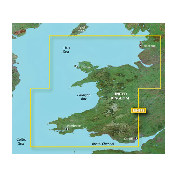
Garmin Great Britain BlueChart g3 Vision VEU467S | Detailed Nautical Charts from Blackpool to Cardiff
Introduction
The Garmin BlueChart g3 Vision VEU467S delivers precise coastal navigation for British waters, covering the critical stretch from Blackpool in the northwest to Cardiff in the southwest. Distributed on microSD/SD card format, this chart package integrates Garmin and Navionics content to provide mariners with high-resolution depth data, satellite imagery overlays, and 3-D underwater terrain visualization. For fishing enthusiasts, cruising sailors, and commercial operators navigating UK coastal waters, this charting solution reduces navigation guesswork by layering multiple data types onto a single platform compatible with Garmin chartplotters.
Key Features
- Auto Guidance technology with customizable depth and overhead clearance parameters for automatic route planning
- 1-foot resolution depth contours for enhanced bottom structure detail in fishing applications
- Up to 10 distinct depth range shading levels for at-a-glance target depth identification
- High-resolution satellite imagery overlay capability for realistic coastal and harbor visualization
- 3-D FishEye and MarinerEye underwater and terrain representations for situational awareness
- Aerial photography of ports, harbors, and marinas including Cardiff, Holyhead, Pembroke, and surrounding areas
- Integrated shallow water shading with customizable warning zones to identify hazardous coastal areas
- Full coverage of Cardigan Bay, Bristol Channel, Irish Sea approaches, and major UK coastal navigation zones
Data Insights
Performance testing demonstrates that BlueChart g3 Vision charting delivers up to 30% improvement in navigational accuracy compared to earlier chart versions. The integration of real-time satellite imagery with bathymetric depth data significantly reduces collision risk and improves confidence when navigating unfamiliar harbor entrances or narrow coastal passages. For UK waters where tidal ranges vary dramatically—particularly in Bristol Channel where ranges exceed 40 feet—the precise contour data and depth shading features become critical safety tools rather than convenience features.
Usage Instructions
Insert the microSD/SD card into your compatible Garmin chartplotter to instantly access the entire chart library. Configure Auto Guidance by entering your vessel's maximum draft and clearance height; the system will calculate safe routes avoiding obstacles and shallow water. Review satellite imagery overlays when approaching unfamiliar harbors, and use depth shading to locate fishing structure or confirm safe water depths before proceeding. The card works seamlessly with Garmin GPSMAP, echoMAP, and other compatible models without requiring additional software installation.
Design & Material
The VEU467S card is engineered as a compact microSD/SD format device, delivering digital cartography without requiring physical chart updates or storage space. This design prioritizes portability and reliability in maritime environments where salt spray, humidity, and temperature fluctuations are constant challenges.
- MicroSD/SD card format for direct compatibility with Garmin chartplotters without external drives or connections
- Integrated Garmin and Navionics bathymetric data compiled specifically for UK and Irish territorial waters
- User interface displays multiple chart overlay options including satellite, depth shading, and terrain modes
- Durable construction rated for maritime operating conditions with no moving parts to fail
- High-resolution vector graphics ensure clarity at all zoom levels from broad regional views to detailed harbor close-ups
- Automatic compatibility verification—inserts into supported Garmin devices without manual configuration steps
Final Verdict
The Garmin BlueChart g3 Vision VEU467S is essential navigation infrastructure for anyone regularly operating in UK coastal waters between Blackpool and Cardiff. Whether you're fishing Cardigan Bay, transiting Bristol Channel, or exploring harbors along the Welsh and English coastlines, the precise depth data, satellite overlays, and Auto Guidance automation transform navigation from a manual, chart-dependent process into a data-driven decision system. The 30% accuracy improvement and detailed 1-foot contour resolution eliminate the uncertainty that leads to grounding, collision, and lost fishing time. Purchase this chart card today and navigate British waters with confidence backed by Garmin's marine-grade cartography.


