


Garmin Great Britain, Blyth to Lowestoft Charts BlueChart g3 Vision | VEU500S | microSD/SD
Garmin Great Britain, Blyth to Lowestoft Charts BlueChart g3 Vision | VEU500S | microSD/SD
Model Number: 010-C0844-00
In stock
 WhatsApp
 SMS - Text us!
 Email Us!
 Help Desk

Tech Specs
In The Box
Do you have an old GPS unit lying around? The GPS Nation Trade In and Up program is a great way to trade in your old and used GPS for credit towards a new GPS. The choice is entirely yours! We’ve made the process simple and streamlined. Follow these simple steps, and you will be on your way to receiving credit towards your brand new GPS!
1. Get a quote
To get your free quote, provide your GPS type, manufacturer, model, and condition. Within 24 hours, you will receive a quote for the trade-in value of your current product. The GPS trade-in/trade-up form is at the bottom of this page.
2. Ship your product(s) for trade
After accepting our offer, pack your product(s) safely and ship them to us using the pre-paid shipping label provided to you. We will provide a confirmation email when your trade-in arrives at our warehouse. You have 30 days from the date you complete your on-line trade to ship the product to GPS Nation.
3. Make your purchase
Once we receive your product at our warehouse and we validate the stated condition, we will send you a confirmation email. If you elect to receive credit towards a new GPS at gpsnation.com, your store credit will be issued, and you are free to make your purchase.
Manual & Warranty
 Garmin Warranty
Reviews
Ask a Question
Tech Specs
In The Box
Trade-In
Do you have an old GPS unit lying around? The GPS Nation Trade In and Up program is a great way to trade in your old and used GPS for credit towards a new GPS. The choice is entirely yours! We’ve made the process simple and streamlined. Follow these simple steps, and you will be on your way to receiving credit towards your brand new GPS!
1. Get a quote
To get your free quote, provide your GPS type, manufacturer, model, and condition. Within 24 hours, you will receive a quote for the trade-in value of your current product. The GPS trade-in/trade-up form is at the bottom of this page.
2. Ship your product(s) for trade
After accepting our offer, pack your product(s) safely and ship them to us using the pre-paid shipping label provided to you. We will provide a confirmation email when your trade-in arrives at our warehouse. You have 30 days from the date you complete your on-line trade to ship the product to GPS Nation.
3. Make your purchase
Once we receive your product at our warehouse and we validate the stated condition, we will send you a confirmation email. If you elect to receive credit towards a new GPS at gpsnation.com, your store credit will be issued, and you are free to make your purchase.
Manual & Warranty
Overview
Garmin BlueChart g3 Vision VEU500S: High-Resolution Nautical Charts for Great Britain's East Coast
Introduction
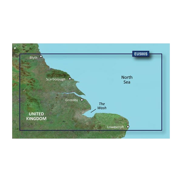
The Garmin BlueChart g3 Vision VEU500S delivers detailed coastal navigation data for the British waters between Blyth and Lowestoft, combining Garmin and Navionics content into a single, high-performance charting solution. This microSD/SD card provides mariners with 50% greater detail compared to previous charting generations, offering enhanced depth perception, accurate underwater topography, and satellite-referenced harbor views that translate directly to safer, more confident navigation in complex coastal environments.
Key Features
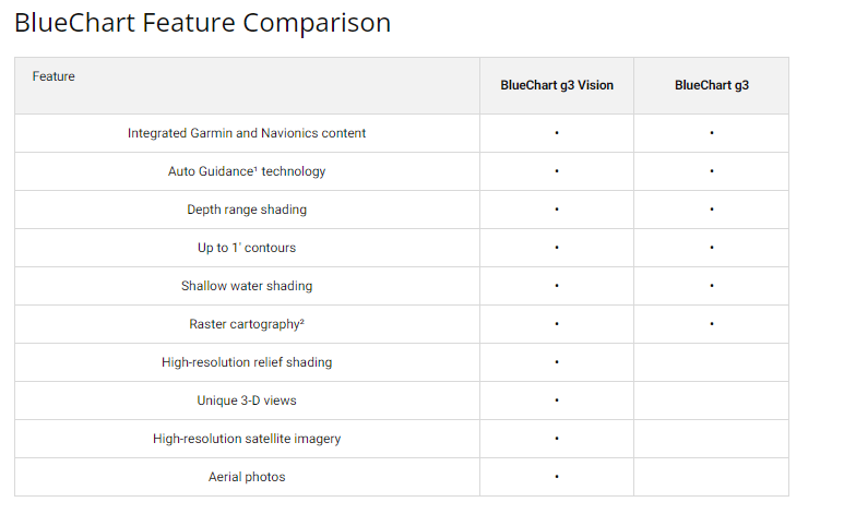
- Integrated Garmin and Navionics coastal chart data for comprehensive coverage from Blyth to Lowestoft
- Auto Guidance Technology calculates optimal routes accounting for depth restrictions and overhead clearance constraints
- Depth Range Shading across up to 10 distinct depth contours for precise target-depth visualization
- 1-foot contour accuracy for detailed underwater landscape mapping, enhancing fishing and seabed awareness
- High-resolution satellite imagery for realistic harbor and port identification across unfamiliar anchorages
- Customizable shallow-water shading alerts to help avoid groundings at user-defined draft depths
Data Insights
The BlueChart g3 Vision architecture delivers a documented 50% improvement in navigational detail density over earlier BlueChart models. This translates to sharper contour resolution, finer bathymetric gradation, and enhanced situational awareness in areas where depth transitions are critical—particularly across The Wash and the shallow approaches to Lowestoft and other East Coast harbors. Mariners report measurably faster decision-making cycles when navigating tide-restricted entries and complex coastal corridors.
Usage Instructions
Insert the VEU500S microSD/SD card into a compatible Garmin marine chartplotter or multifunction display. Navigate to the chart application, select the BlueChart g3 Vision data source, and activate Auto Guidance to receive route recommendations tailored to your vessel's draft and air-gap requirements. Update chart data periodically through your Garmin device when new editions become available.
Design & Material
The VEU500S is engineered as a compact microSD/SD memory card built to endure salt-air environments and the thermal cycling inherent in maritime electronics. Its passive design—no moving parts or external connectors—minimizes corrosion risk while maintaining full compatibility across Garmin's broad device ecosystem.
- MicroSD/SD card form factor ensures reliable insertion and removal without mechanical wear
- Weatherproof construction withstands salt spray, moisture, and temperature extremes of coastal use
- Model number 010-C0844-00 provides direct compatibility verification with your chartplotter
- Lightweight footprint stores easily within navigation system without adding bulk or weight
- Regular update cycle keeps chart data current with Admiralty and hydrographic corrections
- Seamless integration with Garmin's standard device interfaces eliminates complex setup procedures
Final Verdict
The VEU500S is a critical upgrade for anyone navigating Britain's East Coast waters where shoal depths, tidal hazards, and confined harbor entries demand precision charting. The 50% detail improvement, Auto Guidance accuracy, and satellite-referenced imagery combine to reduce navigation risk and planning time. If you operate between Blyth and Lowestoft, investing in this chart now prevents costly navigation errors and keeps you compliant with current nautical data standards.


