


Garmin Great Britain Southeast to Belgium and Luxembourg Charts BlueChart g3 | HXEU002R | microSD/SD
Garmin Great Britain Southeast to Belgium and Luxembourg Charts BlueChart g3 | HXEU002R | microSD/SD
Model Number: 010-C0761-20
In stock
 View full details
 WhatsApp
 SMS - Text us!
 Email Us!
 Help Desk

Tech Specs

In The Box
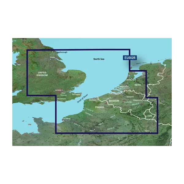
Garmin Bluechart G2 Dover-Amsterdam & England S/E
Manual & Warranty
 Garmin Warranty
Do you have an old GPS unit lying around? The GPS Nation Trade In and Up program is a great way to trade in your old and used GPS for credit towards a new GPS. The choice is entirely yours! We’ve made the process simple and streamlined. Follow these simple steps, and you will be on your way to receiving credit towards your brand new GPS!
1. Get a quote
To get your free quote, provide your GPS type, manufacturer, model, and condition. Within 24 hours, you will receive a quote for the trade-in value of your current product. The GPS trade-in/trade-up form is at the bottom of this page.
2. Ship your product(s) for trade
After accepting our offer, pack your product(s) safely and ship them to us using the pre-paid shipping label provided to you. We will provide a confirmation email when your trade-in arrives at our warehouse. You have 30 days from the date you complete your on-line trade to ship the product to GPS Nation.
3. Make your purchase
Once we receive your product at our warehouse and we validate the stated condition, we will send you a confirmation email. If you elect to receive credit towards a new GPS at gpsnation.com, your store credit will be issued, and you are free to make your purchase.
Reviews
Ask a Question
Tech Specs
In The Box
Garmin Bluechart G2 Dover-Amsterdam & England S/E
Manual & Warranty
Trade-In
Do you have an old GPS unit lying around? The GPS Nation Trade In and Up program is a great way to trade in your old and used GPS for credit towards a new GPS. The choice is entirely yours! We’ve made the process simple and streamlined. Follow these simple steps, and you will be on your way to receiving credit towards your brand new GPS!
1. Get a quote
To get your free quote, provide your GPS type, manufacturer, model, and condition. Within 24 hours, you will receive a quote for the trade-in value of your current product. The GPS trade-in/trade-up form is at the bottom of this page.
2. Ship your product(s) for trade
After accepting our offer, pack your product(s) safely and ship them to us using the pre-paid shipping label provided to you. We will provide a confirmation email when your trade-in arrives at our warehouse. You have 30 days from the date you complete your on-line trade to ship the product to GPS Nation.
3. Make your purchase
Once we receive your product at our warehouse and we validate the stated condition, we will send you a confirmation email. If you elect to receive credit towards a new GPS at gpsnation.com, your store credit will be issued, and you are free to make your purchase.
Overview
Garmin Great Britain Southeast to Belgium and Luxembourg Charts BlueChart g3 | HXEU002R | microSD/SD
Enhance your boating experience with the Garmin Great Britain Southeast to Belgium and Luxembourg Charts BlueChart g3. This advanced charting solution is meticulously designed to offer unparalleled navigation capabilities, ensuring that both seasoned mariners and casual boaters can navigate with precision and confidence. The integration of Garmin and Navionics data guarantees superior clarity, making every journey on the water safer and more enjoyable.
Key Features
- Unparalleled Coastal Chart Coverage: Updated coastal charts provide superior clarity and detail.
- Auto Guidance Technology: Effortlessly compute routes based on desired depth and clearance, with suggested paths overlaid directly on charts.
- Depth Range Shading: High-resolution shading for up to 10 depth ranges for intuitive navigation.
- Detailed Contours: Up to 1-foot contours offer an accurate depiction of underwater structures.
- Shallow Water Shading: User-defined depth shading highlights shallow areas to avoid hazards.
- NOAA Raster Cartography: Access paper chart-like views of NOAA-surveyed areas with labeled points of interest.
Data Insights
This charting solution covers essential regions, including the southeastern UK shores, parts of the North Atlantic coast, and popular inland waterways in Belgium and Luxembourg. Notably, it features approximately 90% coverage of major ports, ensuring comprehensive navigation options. The use of high-resolution data not only enhances navigational accuracy but also contributes to a smoother boating experience.
Usage Instructions
To get the best results from your Garmin BlueChart g3, simply insert the microSD/SD card into your compatible Garmin device. Utilize the Auto Guidance Technology to plan your routes, adjusting depth and clearance settings as needed. Regularly update your charts to ensure you have the latest navigational data at your fingertips.
Design & Material
The Garmin BlueChart g3 is crafted with precision, featuring a user-friendly interface that seamlessly integrates into your navigation system. Its design ensures durability and ease of use in various maritime environments.
- MicroSD/SD Card Format: Easy to install and update.
- High-Quality Data Integration: Combines Garmin and Navionics data for superior accuracy.
- Intuitive User Interface: Simplifies navigation for both beginners and experts.
- Robust Construction: Designed to withstand maritime conditions.
- Compact Size: Easy to store and transport.
- Regular Updates: Ensures access to the most current navigational data.
Final Verdict
The Garmin Great Britain Southeast to Belgium and Luxembourg Charts BlueChart g3 is an essential tool for anyone looking to enhance their navigation experience on the water. With its comprehensive coverage and advanced features, it is your reliable companion for safe and informed boating. Don't miss out on the opportunity to navigate with confidence—get your Garmin BlueChart g3 today!


