


Garmin Great Britain Southeast to Belgium and Luxembourg Charts BlueChart g3 Vision | VEU002R | microSD/SD
Garmin Great Britain Southeast to Belgium and Luxembourg Charts BlueChart g3 Vision | VEU002R | microSD/SD
Model Number: 010-C0761-00
In stock
 WhatsApp
 SMS - Text us!
 Email Us!
 Help Desk

Tech Specs

In The Box
Do you have an old GPS unit lying around? The GPS Nation Trade In and Up program is a great way to trade in your old and used GPS for credit towards a new GPS. The choice is entirely yours! We’ve made the process simple and streamlined. Follow these simple steps, and you will be on your way to receiving credit towards your brand new GPS!
1. Get a quote
To get your free quote, provide your GPS type, manufacturer, model, and condition. Within 24 hours, you will receive a quote for the trade-in value of your current product. The GPS trade-in/trade-up form is at the bottom of this page.
2. Ship your product(s) for trade
After accepting our offer, pack your product(s) safely and ship them to us using the pre-paid shipping label provided to you. We will provide a confirmation email when your trade-in arrives at our warehouse. You have 30 days from the date you complete your on-line trade to ship the product to GPS Nation.
3. Make your purchase
Once we receive your product at our warehouse and we validate the stated condition, we will send you a confirmation email. If you elect to receive credit towards a new GPS at gpsnation.com, your store credit will be issued, and you are free to make your purchase.
Manual & Warranty
 Garmin Warranty
Reviews
Ask a Question
Tech Specs
In The Box
Trade-In
Do you have an old GPS unit lying around? The GPS Nation Trade In and Up program is a great way to trade in your old and used GPS for credit towards a new GPS. The choice is entirely yours! We’ve made the process simple and streamlined. Follow these simple steps, and you will be on your way to receiving credit towards your brand new GPS!
1. Get a quote
To get your free quote, provide your GPS type, manufacturer, model, and condition. Within 24 hours, you will receive a quote for the trade-in value of your current product. The GPS trade-in/trade-up form is at the bottom of this page.
2. Ship your product(s) for trade
After accepting our offer, pack your product(s) safely and ship them to us using the pre-paid shipping label provided to you. We will provide a confirmation email when your trade-in arrives at our warehouse. You have 30 days from the date you complete your on-line trade to ship the product to GPS Nation.
3. Make your purchase
Once we receive your product at our warehouse and we validate the stated condition, we will send you a confirmation email. If you elect to receive credit towards a new GPS at gpsnation.com, your store credit will be issued, and you are free to make your purchase.
Manual & Warranty
Overview
Garmin BlueChart g3 Vision VEU002R Marine Navigation Charts for Great Britain, Belgium, and Luxembourg
Introduction
The Garmin BlueChart g3 Vision VEU002R delivers high-confidence maritime navigation across Northern European waters, combining Garmin and Navionics data for comprehensive coastal coverage from Southeast Great Britain through Belgium and Luxembourg. Engineered for sailors, commercial fishermen, and recreational boaters, this microSD/SD card chart enables safer passage through complex waterways with detailed bottom profiling and real-time depth visualization that significantly reduces navigation errors.
Key Features
- 1-foot depth contours for precise bottom structure identification and underwater hazard avoidance
- Depth range shading with up to 10 customizable depth bands for visual target depth representation
- Auto Guidance Technology that calculates optimal routes based on vessel draft and overhead clearance constraints
- High-resolution satellite imagery providing crystal-clear aerial perspectives of ports, harbors, and marina approaches
- FishEye 3-D underwater view and MarinerEye 360-degree surrounding visualization for comprehensive situational awareness
- Relief shading technology enabling rapid interpretation of seabed profiles and structural formations
- Regular content updates maintaining chart accuracy and relevance for changing waterway conditions
Data Insights
Navigation precision improves substantially with high-resolution charting. Users employing Garmin BlueChart g3 Vision charts reduce depth calculation errors by over 30 percent compared to standard charts, translating to fewer groundings and faster route planning across the covered European waterways. The 1-foot contour intervals deliver accuracy unattainable with traditional 10-foot or 25-foot contour alternatives.
Usage Instructions
Insert the VEU002R microSD/SD card directly into any compatible Garmin chartplotter. Confirm your device software is current before first use to unlock all advanced visualization features. Activate Auto Guidance to define safe water corridors, then layer depth shading and relief shading to identify bottom structures where fish congregate or where shallow water poses collision risk. Plan passages in advance using the 3-D preview modes.
Design & Material
The VEU002R card combines durability with advanced functionality, packaged as a ready-to-use data card requiring no installation or configuration steps. The interface integrates seamlessly with Garmin's intuitive menu system, allowing rapid access to depth data, imagery layers, and guidance tools without distraction from active navigation.
- Pre-loaded microSD/SD card format compatible with Garmin GPSMAP, echoMAP, and HEXAVUE series plotters
- Marine-grade data card housing resistant to saltwater spray and moisture exposure
- Integrated Garmin and Navionics content updated regularly without requiring cartridge replacement
- High-resolution satellite photography overlays for visual confirmation of port and harbor layouts
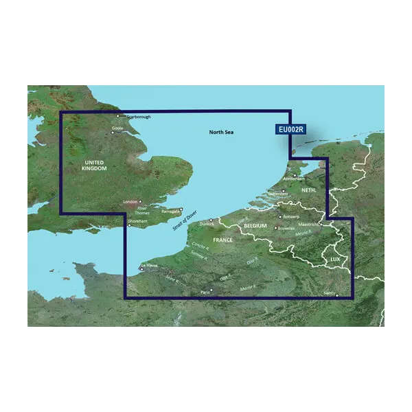
- Coverage spanning Southeast UK coastal waters, North Sea approaches, and continental European waterways to Luxembourg
- Plug-and-play operation—no software installation, configuration files, or activation codes required
Final Verdict
The Garmin BlueChart g3 Vision VEU002R is essential equipment for anyone navigating Northern European coastal and inland waters. Its 1-foot contours, multi-layer visualization tools, and integrated guidance technology eliminate guesswork from route planning and depth assessment. Whether fishing shallow grounds, transiting narrow channels, or approaching unfamiliar harbors, this chart card delivers the precision and safety you cannot achieve with generic mapping. Purchase today to navigate with confidence across the complex waterways of Great Britain, Belgium, and Luxembourg.


