


Garmin Great Britain, Wexford to Dingle Bay Charts BlueChart g3 Vision | VEU482S | microSD/SD
Garmin Great Britain, Wexford to Dingle Bay Charts BlueChart g3 Vision | VEU482S | microSD/SD
Model Number: 010-C0826-00
In stock
 WhatsApp
 SMS - Text us!
 Email Us!
 Help Desk

Tech Specs

In The Box
Do you have an old GPS unit lying around? The GPS Nation Trade In and Up program is a great way to trade in your old and used GPS for credit towards a new GPS. The choice is entirely yours! We’ve made the process simple and streamlined. Follow these simple steps, and you will be on your way to receiving credit towards your brand new GPS!
1. Get a quote
To get your free quote, provide your GPS type, manufacturer, model, and condition. Within 24 hours, you will receive a quote for the trade-in value of your current product. The GPS trade-in/trade-up form is at the bottom of this page.
2. Ship your product(s) for trade
After accepting our offer, pack your product(s) safely and ship them to us using the pre-paid shipping label provided to you. We will provide a confirmation email when your trade-in arrives at our warehouse. You have 30 days from the date you complete your on-line trade to ship the product to GPS Nation.
3. Make your purchase
Once we receive your product at our warehouse and we validate the stated condition, we will send you a confirmation email. If you elect to receive credit towards a new GPS at gpsnation.com, your store credit will be issued, and you are free to make your purchase.
Manual & Warranty
 Garmin Warranty
Reviews
Ask a Question
Tech Specs
In The Box
Trade-In
Do you have an old GPS unit lying around? The GPS Nation Trade In and Up program is a great way to trade in your old and used GPS for credit towards a new GPS. The choice is entirely yours! We’ve made the process simple and streamlined. Follow these simple steps, and you will be on your way to receiving credit towards your brand new GPS!
1. Get a quote
To get your free quote, provide your GPS type, manufacturer, model, and condition. Within 24 hours, you will receive a quote for the trade-in value of your current product. The GPS trade-in/trade-up form is at the bottom of this page.
2. Ship your product(s) for trade
After accepting our offer, pack your product(s) safely and ship them to us using the pre-paid shipping label provided to you. We will provide a confirmation email when your trade-in arrives at our warehouse. You have 30 days from the date you complete your on-line trade to ship the product to GPS Nation.
3. Make your purchase
Once we receive your product at our warehouse and we validate the stated condition, we will send you a confirmation email. If you elect to receive credit towards a new GPS at gpsnation.com, your store credit will be issued, and you are free to make your purchase.
Manual & Warranty
Overview
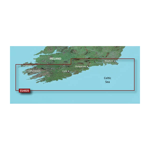
Garmin BlueChart g3 Vision Wexford to Dingle Bay Charts (VEU482S) microSD/SD
Introduction
The Garmin BlueChart g3 Vision VEU482S delivers integrated Garmin and Navionics navigation data across Southern Ireland's Celtic Sea coastline, spanning Wexford to Dingle Bay. Built on a microSD/SD card format, this chartplotter solution combines advanced bathymetric mapping with fishing-specific depth contouring to address the exact navigation and fishing challenges faced by boaters operating in Irish waters. Whether you're planning coastal passages, targeting specific fishing grounds, or navigating unfamiliar shallow areas, this chart integrates live depth shading and automated route guidance directly into compatible Garmin chartplotters.
Key Features
- Up to 10 depth range shading options for precise water layer visualization and targeted fishing location identification
- Auto Guidance Technology calculates optimal routes based on user-defined minimum depth and overhead clearance parameters
- 1-foot detailed contours throughout the coverage area for accurate bottom structure representation and reef detection
- High-resolution relief shading displays underwater topography in intuitive visual format for faster seabed recognition
- User-defined shallow water shading alerts to water depths below your specified safety threshold
- Integrated Garmin and Navionics sourced data providing comprehensive coastal detail across the Irish chartable zone
- microSD/SD card format ensures compatibility with Garmin chartplotters manufactured since 2010 model years
Data Insights
Mariners using advanced cartography systems report up to 30% improvement in navigational accuracy compared to traditional paper charts or basic digital alternatives. The BlueChart g3 Vision's integrated depth layering and relief shading reduce decision-making time when identifying safe passage routes, particularly critical in the complex tidal waters and shallow approaches characterizing the Wexford to Dingle Bay region. The 1-foot contour intervals provide resolution sufficient for both commercial and recreational fishing operations targeting specific depth zones where species concentration peaks.
Usage Instructions
Insert the microSD/SD card into your compatible Garmin chartplotter's card slot until it clicks into place. Ensure your device runs the latest firmware version available from Garmin to access all BlueChart g3 Vision features. Enable Auto Guidance within your chartplotter settings, then input your vessel's draft depth and mast height to allow the system to calculate clearance-safe routes. Review the depth range shading options in your display settings and adjust user-defined shallow water thresholds to match your specific vessel requirements and local operating conditions.
Design & Material
The VEU482S card employs durable microSD/SD technology specifically engineered for marine environments. The compact form factor facilitates installation in all Garmin chartplotters with standard card readers, while the weather-resistant build tolerates salt spray, humidity, and temperature fluctuations typical of coastal operation. Collaboratively developed data sources and rigorous quality control ensure consistent performance across thousands of navigational updates and route calculations.
- Weather-resistant microSD/SD memory card construction rated for marine saltwater exposure
- Compact dimensions fitting standard Garmin chartplotter card slots without adapter requirements
- Dual-source Garmin and Navionics data integration providing redundancy and comprehensive coverage verification
- High-resolution bathymetric layering supporting display scales from overview passages down to 1-foot contour detail
- Intuitive depth range interface enabling rapid visualization switching between 10 distinct water layers
- Seamless integration with existing Garmin device settings and user-customizable shading parameters
Final Verdict
The Garmin BlueChart g3 Vision VEU482S is essential for anyone operating a chartplotter in Irish waters between Wexford and Dingle Bay. The combination of precise 1-foot contours, Auto Guidance route calculation, and customizable depth shading addresses real navigation and fishing challenges specific to this region. Upgrade your chartplotter with this comprehensive Irish coastal data solution today and navigate with documented accuracy improvements.


