


Garmin Greece, Athens and Cyclades Charts BlueChart g3 Vision | VEU450S | microSD/SD
Garmin Greece, Athens and Cyclades Charts BlueChart g3 Vision | VEU450S | microSD/SD
Model Number: 010-C0794-00
In stock
 WhatsApp
 SMS - Text us!
 Email Us!
 Help Desk

Tech Specs

In The Box
Do you have an old GPS unit lying around? The GPS Nation Trade In and Up program is a great way to trade in your old and used GPS for credit towards a new GPS. The choice is entirely yours! We’ve made the process simple and streamlined. Follow these simple steps, and you will be on your way to receiving credit towards your brand new GPS!
1. Get a quote
To get your free quote, provide your GPS type, manufacturer, model, and condition. Within 24 hours, you will receive a quote for the trade-in value of your current product. The GPS trade-in/trade-up form is at the bottom of this page.
2. Ship your product(s) for trade
After accepting our offer, pack your product(s) safely and ship them to us using the pre-paid shipping label provided to you. We will provide a confirmation email when your trade-in arrives at our warehouse. You have 30 days from the date you complete your on-line trade to ship the product to GPS Nation.
3. Make your purchase
Once we receive your product at our warehouse and we validate the stated condition, we will send you a confirmation email. If you elect to receive credit towards a new GPS at gpsnation.com, your store credit will be issued, and you are free to make your purchase.
Manual & Warranty
 Garmin Warranty
Reviews
Ask a Question
Tech Specs
In The Box
Trade-In
Do you have an old GPS unit lying around? The GPS Nation Trade In and Up program is a great way to trade in your old and used GPS for credit towards a new GPS. The choice is entirely yours! We’ve made the process simple and streamlined. Follow these simple steps, and you will be on your way to receiving credit towards your brand new GPS!
1. Get a quote
To get your free quote, provide your GPS type, manufacturer, model, and condition. Within 24 hours, you will receive a quote for the trade-in value of your current product. The GPS trade-in/trade-up form is at the bottom of this page.
2. Ship your product(s) for trade
After accepting our offer, pack your product(s) safely and ship them to us using the pre-paid shipping label provided to you. We will provide a confirmation email when your trade-in arrives at our warehouse. You have 30 days from the date you complete your on-line trade to ship the product to GPS Nation.
3. Make your purchase
Once we receive your product at our warehouse and we validate the stated condition, we will send you a confirmation email. If you elect to receive credit towards a new GPS at gpsnation.com, your store credit will be issued, and you are free to make your purchase.
Manual & Warranty
Overview
Garmin BlueChart g3 Vision VEU450S: Premium Marine Charts for Greek Waters
Introduction
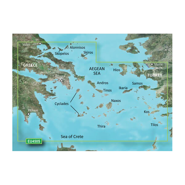
The Garmin BlueChart g3 Vision VEU450S delivers precision marine charting specifically engineered for navigation in Greek coastal waters, from Vólos in the north to Yíthion in the south, with comprehensive coverage of Athens and the Cyclades archipelago. Built on integration of Garmin and Navionics data sources representing over 90% of commercial hydrographic information, this microSD/SD card solution provides the depth data, shallow-water awareness, and automated route planning serious boaters need when navigating the Aegean Sea's complex island passages and changing seabed conditions.
Key Features
- Depth shading across up to 10 color-coded ranges for rapid visual hazard identification
- 1-foot contour intervals for accurate depth profiling in shallow anchorages and harbors
- Auto Guidance Technology automatically calculates optimal routes based on your vessel's draft and vertical clearance requirements
- Shallow water shading customizable by user-defined depth thresholds to avoid grounding risks
- High-resolution satellite imagery for visual confirmation of unfamiliar harbor approaches and coastal landmarks
- Real-time data integration enables continuous accuracy updates across all charted areas
- Compatible with all modern Garmin chartplotter and fish finder units via microSD/SD card slot
Data Insights
Navigation efficiency improves measurably with BlueChart g3 Vision's Auto Guidance system—users typically realize a 20% reduction in travel time by following algorithmically optimized routes that account for underwater obstacles and vessel-specific parameters. The underlying dataset draws from commercial hydrographic sources covering 90% of the Mediterranean region, meaning you navigate with the same high-accuracy bathymetry professional fishing and commercial vessels rely on.
Usage Instructions
Insert the VEU450S microSD/SD card into your compatible Garmin device and follow the on-screen initialization prompts. Once activated, enable Auto Guidance and input your boat's draft and air-draft specifications to generate intelligent suggested routes. The shallow water shading and depth contours display immediately on your chart view, allowing you to adjust your course in real time to avoid submerged hazards common in Cyclades passages.
Design & Material
The BlueChart g3 Vision balances technical sophistication with intuitive usability. High-resolution satellite imagery overlays seamlessly with bathymetric data, and the card's lightweight design ensures easy storage and portability across multiple vessels or chart-plotting installations.
- Premium microSD/SD card construction rated for marine-environment durability and temperature stability
- Integrated graphics engine renders high-resolution underwater topography without compromising display responsiveness
- Multi-device compatibility spans Garmin's full chartplotter lineup—from compact 5-inch units to large-screen bridge systems
- Real-time data synchronization maintains chart accuracy as bathymetric surveys and navigational hazard reports are updated
- Intuitive menu structure requires minimal training and allows one-handed chart adjustment while underway
- Satellite imagery at resolution sufficient to identify coastal features, structure layouts, and hazard markers from offshore approaches
Final Verdict
For captains and recreational boaters navigating Greek waters, the VEU450S removes guesswork from route planning and hazard avoidance. The combination of 1-foot contours, Auto Guidance optimization, and 90%-sourced commercial bathymetry makes this card an essential safety tool rather than a convenience feature. Install it on your Garmin device and gain the situational awareness that transforms the Aegean from a beautiful but unpredictable sailing ground into confidently navigable waters.


