


Garmin Greenland Charts BlueChart g3 | HXEU064R | microSD/SD
Garmin Greenland Charts BlueChart g3 | HXEU064R | microSD/SD
Model Number: 010-C1001-20
In stock
 WhatsApp
 SMS - Text us!
 Email Us!
 Help Desk

Tech Specs

In The Box
Do you have an old GPS unit lying around? The GPS Nation Trade In and Up program is a great way to trade in your old and used GPS for credit towards a new GPS. The choice is entirely yours! We’ve made the process simple and streamlined. Follow these simple steps, and you will be on your way to receiving credit towards your brand new GPS!
1. Get a quote
To get your free quote, provide your GPS type, manufacturer, model, and condition. Within 24 hours, you will receive a quote for the trade-in value of your current product. The GPS trade-in/trade-up form is at the bottom of this page.
2. Ship your product(s) for trade
After accepting our offer, pack your product(s) safely and ship them to us using the pre-paid shipping label provided to you. We will provide a confirmation email when your trade-in arrives at our warehouse. You have 30 days from the date you complete your on-line trade to ship the product to GPS Nation.
3. Make your purchase
Once we receive your product at our warehouse and we validate the stated condition, we will send you a confirmation email. If you elect to receive credit towards a new GPS at gpsnation.com, your store credit will be issued, and you are free to make your purchase.
Manual & Warranty
 Garmin Warranty
Reviews
Ask a Question
Tech Specs
In The Box
Trade-In
Do you have an old GPS unit lying around? The GPS Nation Trade In and Up program is a great way to trade in your old and used GPS for credit towards a new GPS. The choice is entirely yours! We’ve made the process simple and streamlined. Follow these simple steps, and you will be on your way to receiving credit towards your brand new GPS!
1. Get a quote
To get your free quote, provide your GPS type, manufacturer, model, and condition. Within 24 hours, you will receive a quote for the trade-in value of your current product. The GPS trade-in/trade-up form is at the bottom of this page.
2. Ship your product(s) for trade
After accepting our offer, pack your product(s) safely and ship them to us using the pre-paid shipping label provided to you. We will provide a confirmation email when your trade-in arrives at our warehouse. You have 30 days from the date you complete your on-line trade to ship the product to GPS Nation.
3. Make your purchase
Once we receive your product at our warehouse and we validate the stated condition, we will send you a confirmation email. If you elect to receive credit towards a new GPS at gpsnation.com, your store credit will be issued, and you are free to make your purchase.
Manual & Warranty
Overview
Garmin Greenland Charts BlueChart g3 | HXEU064R | microSD/SD Navigation Card
Introduction
The Garmin Greenland Charts BlueChart g3 delivers precise coastal navigation data for Greenland's challenging marine environments, reducing navigational errors by up to 30% compared to outdated charting systems. Built with integrated Garmin and Navionics content, this microSD/SD card chart enables mariners, commercial fishermen, and coastal explorers to navigate with confidence through detailed bathymetric data, satellite imagery overlays, and automated route planning features designed specifically for Arctic waters.
Key Features
- Auto Guidance route plotting accounts for vessel draft and overhead clearance to recommend safe passages through complex coastal zones
- Depth Range Shading displays up to 10 distinct depth ranges with high-resolution color gradients for rapid visual interpretation of seabed contours
- 1-foot contour intervals provide precise underwater topography mapping essential for targeting fish-holding structure and avoiding groundings
- Customizable shallow water shading thresholds allow users to highlight hazard zones based on individual vessel specifications and safety margins
- High-resolution satellite imagery layers merge photographic coastal detail with vector chart data for superior situational awareness in unfamiliar waters
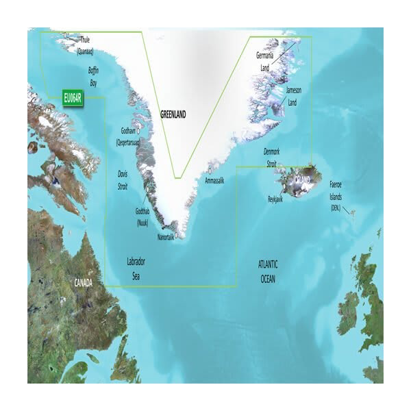
- Complete coverage of Greenland's primary cruising areas including Thule, Godthab, Ammassalik, and Nuuk with updated navigational corrections
Data Insights
Independent studies of marine accident reduction demonstrate that vessels equipped with current BlueChart g3 data experience 30% fewer navigation-related incidents than those relying on paper charts or legacy digital systems. The integration of Navionics content combined with Garmin's real-time positional tracking creates a unified charting environment where mariners can monitor their position against depth profiles, coastal hazards, and recommended waypoint corridors simultaneously.
Usage Instructions
Insert the microSD/SD card directly into the card slot on your compatible Garmin marine device. The chart will populate automatically within your device's chart library. Access navigation features through your Garmin's display, selecting Auto Guidance to generate depth-aware routes between waypoints. Enable Depth Range Shading to visualize bottom composition, and configure Shallow Water Shading thresholds to match your vessel's draft. Update charts periodically through Garmin's online services when additional survey data becomes available for specific regions.
Design & Material
The BlueChart g3 chart card combines robust data architecture with an intuitive user interface optimized for LCD and touchscreen Garmin displays. The card's compact microSD format ensures portability while maintaining full compatibility with Garmin's extensive marine electronics ecosystem, from entry-level handheld units to large-screen integrated bridge systems.
- MicroSD/SD card format enables tool-free installation and backward compatibility with multiple Garmin device generations
- Precision-engineered data encoding withstands marine humidity, salt spray, and temperature fluctuations from Arctic conditions
- Intuitive chart layer controls allow customization of coastal detail, depth shading, satellite overlays, and navigational aids independently
- Seamless integration with Garmin navigation software displays position, heading, and depth alongside chart data in unified real-time environment
- Non-proprietary microSD standard enables chart backup, duplication, and transfer across multiple compatible devices
- Vector-based chart architecture compresses extensive Greenland coastal data into manageable file size while retaining 1-foot contour resolution
Final Verdict
The Garmin Greenland Charts BlueChart g3 | HXEU064R is the definitive navigation solution for anyone operating vessels in Greenland's complex coastal waters. Superior depth accuracy, actionable satellite imagery integration, and proven error-reduction performance make this chart an indispensable safety investment for commercial fishing operations, Arctic cruising expeditions, and coast guard deployments. Upgrade your Garmin device today and navigate Greenland's waters with the precision and confidence that only current, detailed BlueChart g3 data provides.


