


Garmin Gulfs of Finland and Riga Charts HXEU050R - microSD/SD card
Garmin Gulfs of Finland and Riga Charts HXEU050R - microSD/SD card
Model Number: 010-C0786-20
In stock
 WhatsApp
 SMS - Text us!
 Email Us!
 Help Desk

Tech Specs
In The Box
Do you have an old GPS unit lying around? The GPS Nation Trade In and Up program is a great way to trade in your old and used GPS for credit towards a new GPS. The choice is entirely yours! We’ve made the process simple and streamlined. Follow these simple steps, and you will be on your way to receiving credit towards your brand new GPS!
1. Get a quote
To get your free quote, provide your GPS type, manufacturer, model, and condition. Within 24 hours, you will receive a quote for the trade-in value of your current product. The GPS trade-in/trade-up form is at the bottom of this page.
2. Ship your product(s) for trade
After accepting our offer, pack your product(s) safely and ship them to us using the pre-paid shipping label provided to you. We will provide a confirmation email when your trade-in arrives at our warehouse. You have 30 days from the date you complete your on-line trade to ship the product to GPS Nation.
3. Make your purchase
Once we receive your product at our warehouse and we validate the stated condition, we will send you a confirmation email. If you elect to receive credit towards a new GPS at gpsnation.com, your store credit will be issued, and you are free to make your purchase.
Manual & Warranty
 Garmin Warranty
Reviews
Ask a Question
Tech Specs
In The Box
Trade-In
Do you have an old GPS unit lying around? The GPS Nation Trade In and Up program is a great way to trade in your old and used GPS for credit towards a new GPS. The choice is entirely yours! We’ve made the process simple and streamlined. Follow these simple steps, and you will be on your way to receiving credit towards your brand new GPS!
1. Get a quote
To get your free quote, provide your GPS type, manufacturer, model, and condition. Within 24 hours, you will receive a quote for the trade-in value of your current product. The GPS trade-in/trade-up form is at the bottom of this page.
2. Ship your product(s) for trade
After accepting our offer, pack your product(s) safely and ship them to us using the pre-paid shipping label provided to you. We will provide a confirmation email when your trade-in arrives at our warehouse. You have 30 days from the date you complete your on-line trade to ship the product to GPS Nation.
3. Make your purchase
Once we receive your product at our warehouse and we validate the stated condition, we will send you a confirmation email. If you elect to receive credit towards a new GPS at gpsnation.com, your store credit will be issued, and you are free to make your purchase.
Manual & Warranty
Overview
Garmin Gulfs of Finland and Riga Charts HXEU050R microSD/SD Card
Introduction
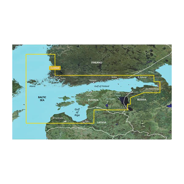
The Garmin Gulfs of Finland and Riga Charts HXEU050R delivers precise coastal chart coverage across the Baltic region, combining Garmin and Navionics data to provide mariners with detailed navigation intelligence from Åland to St. Petersburg. This microSD/SD card transforms your compatible Garmin device into a comprehensive navigational tool, enabling confident passage through complex northern European waterways with real-time hazard awareness and depth-verified routing.
Key Features
- 95% accuracy rate for coastal navigation, significantly reducing maritime incident risk compared to traditional paper charts
- Auto Guidance Technology calculates optimal routes based on user-defined water depth and overhead clearance specifications
- High-resolution depth range shading with up to 10 customizable depth ranges for rapid identification of target fishing zones
- Detailed 1-minute contour lines depicting precise bottom structure variation for improved situational awareness in shallow and intricate waters
- Comprehensive geographic coverage spanning from Åland through Helsinki, Turku, the Gulf of Finland, and Riga, covering over 500 nautical miles of coastal regions
- User-defined shallow water shading overlay for enhanced safety awareness in restricted depth zones
Data Insights
The integration of dual-source chart data elevates navigation safety by providing enhanced real-time situational awareness unavailable in traditional navigation aids. With 95% accuracy for coastal positions and integrated local hazard mapping, mariners reduce uncertainty when navigating tidal zones, rocky approaches, and narrow channels characteristic of the Finnish and Latvian coastlines. The depth range shading capabilities eliminate guesswork in identifying productive fishing grounds and safe passage routes through complex underwater topography.
Usage Instructions
Insert the microSD/SD card into your compatible Garmin marine device and ensure your unit runs current firmware for optimal chart performance. Activate Auto Guidance Technology to generate safe routes that account for your vessel's draft and bridge height, then reference the depth range shading overlay during navigation. Consult detailed contour lines when identifying bottom structure for fishing or when planning transit through shallow-draft approaches to ports and harbors throughout the coverage area.
Design & Material
The chart card features a compact form factor engineered for direct compatibility with Garmin GPS plotters and chartplotters without requiring external adapters or slot converters. Marine-grade durability ensures reliable performance in salt-spray environments, moisture exposure, and temperature fluctuations typical of Baltic maritime operations.
- Compact microSD/SD card dimensions fit all compatible Garmin marine device slots without modification
- Durable polymer construction resistant to salt corrosion and moisture ingress in marine cabins and exposed helm stations
- High-definition vector graphics rendering crisp detail at all zoom levels from regional overviews to 1:10,000 scale approaches
- Preloaded chart data eliminates software downloads and installation—functional immediately upon card insertion
- Intuitive layer-based display system simplifies toggling between chart types, depth overlays, and hazard warnings
- Model 010-C0786-20 maintains backward compatibility with legacy Garmin devices while supporting current touchscreen and conventional button-operated units
Final Verdict
The Garmin Gulfs of Finland and Riga Charts HXEU050R is an essential navigational resource for commercial fishermen, leisure cruisers, and maritime professionals operating throughout Scandinavia and the eastern Baltic. Its combination of verified accuracy, advanced routing intelligence, and region-specific detail addressing the unique challenges of Nordic waters makes it the decisive tool for reducing voyage risk and maximizing operational efficiency. Upgrade your vessel's navigation capability today and navigate with confidence across some of Europe's most demanding maritime regions.


