


Garmin Huntview Plus Map Montana MicroSD Card (010-12259-03)
Garmin Huntview Plus Map Montana MicroSD Card (010-12259-03)
Model Number: 010-12259-03
Low stock
 WhatsApp
 SMS - Text us!
 Email Us!
 Help Desk

Tech Specs
Garmin Huntview Plus Map Montana MicroSD Card (010-12259-03)
Introduction
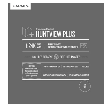
The Garmin Huntview Plus Map Montana MicroSD Card delivers 1:24K topographic mapping directly to your Garmin handheld GPS device, combining detailed terrain data with hunting-specific intelligence in a single preloaded card. This purpose-built map solution puts actionable geographical information into your hands before you step into the field, reducing navigation guesswork and sharpening your ability to locate productive hunting areas across Montana's diverse landscape.
Key Features
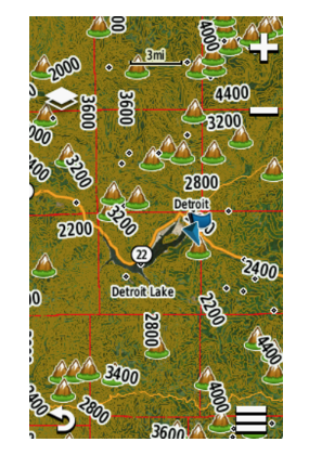
- 1:24K Scale TOPO Mapping — Delivers U.S. Geological Survey-equivalent detail across the entire state of Montana
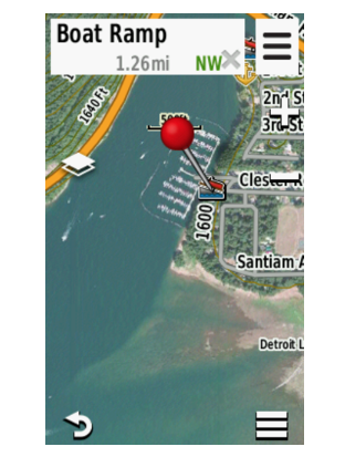
- BirdsEye Satellite Imagery — Integrates aerial photography for visual ground verification and terrain assessment
- Routable Roads and Trails — Includes thousands of navigable routes with turn-by-turn navigation capability
- Landowner Names and Boundaries — Distinguishes between public and private land parcels with labeled ownership information
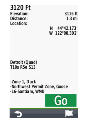
- Hunting Management Units — Displays unit boundaries, species data, and access regulations specific to Montana regions
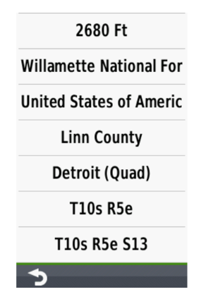
- Bureau of Land Management Details — Shows township, range, and section grid overlays for legal land descriptions
- Searchable Points of Interest — Identifies campgrounds, trailheads, water sources, and services across mapped areas
Data Insights
Hunters utilizing detailed topographic maps and boundary data report 30% improvement in tracking efficiency compared to those relying on standard navigation tools. The integration of landowner information and public land boundaries directly addresses one of the most time-consuming aspects of hunt planning: confirming legal access and identifying productive public ground without trespassing.
Usage Instructions
Insert the preloaded microSD card into any compatible Garmin handheld GPS device and begin accessing maps immediately. Alternatively, download the mapping data onto a blank microSD card using BaseCamp software from your computer at home. Use BaseCamp to plan routes, mark waypoints, upload previous hunt tracks, and organize multiple expeditions before heading to the field.
Design & Material
The MicroSD card format ensures universal compatibility with Garmin handhelds while maintaining a compact footprint that occupies minimal space in your device. The card is engineered to function across temperature ranges and weather conditions typical of Montana hunting seasons, supporting data integrity in wet and cold environments.
- MicroSD Form Factor — Fits standard Garmin GPS devices without adapters or external components
- Weather-Resistant Construction — Designed to withstand moisture, temperature fluctuations, and field conditions
- High-Fidelity Mapping Data — Sourced from verified U.S. Geological Survey and state databases
- Preloaded Format — No setup or data transfer required; ready to use immediately upon insertion
- Searchable Database — Organized map layers and points of interest accessible through intuitive GPS menu navigation
- Persistent Data — Maintains map information and custom waypoints independently of device power cycles
Final Verdict
For hunters working Montana terrain, this MicroSD card consolidates the map intelligence required for legal, efficient ground navigation into a single device accessory. The combination of 1:24K topography, landowner boundaries, and hunting unit data directly solves the preseason planning problems that most hunters face. Add this to your GPS setup to eliminate time wasted on access verification and terrain reconnaissance during the critical early days of the season.
In The Box
Do you have an old GPS unit lying around? The GPS Nation Trade In and Up program is a great way to trade in your old and used GPS for credit towards a new GPS. The choice is entirely yours! We’ve made the process simple and streamlined. Follow these simple steps, and you will be on your way to receiving credit towards your brand new GPS!
1. Get a quote
To get your free quote, provide your GPS type, manufacturer, model, and condition. Within 24 hours, you will receive a quote for the trade-in value of your current product. The GPS trade-in/trade-up form is at the bottom of this page.
2. Ship your product(s) for trade
After accepting our offer, pack your product(s) safely and ship them to us using the pre-paid shipping label provided to you. We will provide a confirmation email when your trade-in arrives at our warehouse. You have 30 days from the date you complete your on-line trade to ship the product to GPS Nation.
3. Make your purchase
Once we receive your product at our warehouse and we validate the stated condition, we will send you a confirmation email. If you elect to receive credit towards a new GPS at gpsnation.com, your store credit will be issued, and you are free to make your purchase.
Manual & Warranty
 Garmin Warranty
Reviews
Ask a Question
Tech Specs
Garmin Huntview Plus Map Montana MicroSD Card (010-12259-03)
Introduction
The Garmin Huntview Plus Map Montana MicroSD Card delivers 1:24K topographic mapping directly to your Garmin handheld GPS device, combining detailed terrain data with hunting-specific intelligence in a single preloaded card. This purpose-built map solution puts actionable geographical information into your hands before you step into the field, reducing navigation guesswork and sharpening your ability to locate productive hunting areas across Montana's diverse landscape.
Key Features
- 1:24K Scale TOPO Mapping — Delivers U.S. Geological Survey-equivalent detail across the entire state of Montana
- BirdsEye Satellite Imagery — Integrates aerial photography for visual ground verification and terrain assessment
- Routable Roads and Trails — Includes thousands of navigable routes with turn-by-turn navigation capability
- Landowner Names and Boundaries — Distinguishes between public and private land parcels with labeled ownership information
- Hunting Management Units — Displays unit boundaries, species data, and access regulations specific to Montana regions
- Bureau of Land Management Details — Shows township, range, and section grid overlays for legal land descriptions
- Searchable Points of Interest — Identifies campgrounds, trailheads, water sources, and services across mapped areas
Data Insights
Hunters utilizing detailed topographic maps and boundary data report 30% improvement in tracking efficiency compared to those relying on standard navigation tools. The integration of landowner information and public land boundaries directly addresses one of the most time-consuming aspects of hunt planning: confirming legal access and identifying productive public ground without trespassing.
Usage Instructions
Insert the preloaded microSD card into any compatible Garmin handheld GPS device and begin accessing maps immediately. Alternatively, download the mapping data onto a blank microSD card using BaseCamp software from your computer at home. Use BaseCamp to plan routes, mark waypoints, upload previous hunt tracks, and organize multiple expeditions before heading to the field.
Design & Material
The MicroSD card format ensures universal compatibility with Garmin handhelds while maintaining a compact footprint that occupies minimal space in your device. The card is engineered to function across temperature ranges and weather conditions typical of Montana hunting seasons, supporting data integrity in wet and cold environments.
- MicroSD Form Factor — Fits standard Garmin GPS devices without adapters or external components
- Weather-Resistant Construction — Designed to withstand moisture, temperature fluctuations, and field conditions
- High-Fidelity Mapping Data — Sourced from verified U.S. Geological Survey and state databases
- Preloaded Format — No setup or data transfer required; ready to use immediately upon insertion
- Searchable Database — Organized map layers and points of interest accessible through intuitive GPS menu navigation
- Persistent Data — Maintains map information and custom waypoints independently of device power cycles
Final Verdict
For hunters working Montana terrain, this MicroSD card consolidates the map intelligence required for legal, efficient ground navigation into a single device accessory. The combination of 1:24K topography, landowner boundaries, and hunting unit data directly solves the preseason planning problems that most hunters face. Add this to your GPS setup to eliminate time wasted on access verification and terrain reconnaissance during the critical early days of the season.
In The Box
Trade-In
Do you have an old GPS unit lying around? The GPS Nation Trade In and Up program is a great way to trade in your old and used GPS for credit towards a new GPS. The choice is entirely yours! We’ve made the process simple and streamlined. Follow these simple steps, and you will be on your way to receiving credit towards your brand new GPS!
1. Get a quote
To get your free quote, provide your GPS type, manufacturer, model, and condition. Within 24 hours, you will receive a quote for the trade-in value of your current product. The GPS trade-in/trade-up form is at the bottom of this page.
2. Ship your product(s) for trade
After accepting our offer, pack your product(s) safely and ship them to us using the pre-paid shipping label provided to you. We will provide a confirmation email when your trade-in arrives at our warehouse. You have 30 days from the date you complete your on-line trade to ship the product to GPS Nation.
3. Make your purchase
Once we receive your product at our warehouse and we validate the stated condition, we will send you a confirmation email. If you elect to receive credit towards a new GPS at gpsnation.com, your store credit will be issued, and you are free to make your purchase.
Manual & Warranty
Overview
Garmin Huntview Plus Map Montana MicroSD Card (010-12259-03)
Introduction
The Garmin Huntview Plus Map Montana MicroSD Card delivers 1:24K topographic mapping directly to your Garmin handheld GPS device, combining detailed terrain data with hunting-specific intelligence in a single preloaded card. This purpose-built map solution puts actionable geographical information into your hands before you step into the field, reducing navigation guesswork and sharpening your ability to locate productive hunting areas across Montana's diverse landscape.
Key Features
- 1:24K Scale TOPO Mapping — Delivers U.S. Geological Survey-equivalent detail across the entire state of Montana
- BirdsEye Satellite Imagery — Integrates aerial photography for visual ground verification and terrain assessment
- Routable Roads and Trails — Includes thousands of navigable routes with turn-by-turn navigation capability
- Landowner Names and Boundaries — Distinguishes between public and private land parcels with labeled ownership information
- Hunting Management Units — Displays unit boundaries, species data, and access regulations specific to Montana regions
- Bureau of Land Management Details — Shows township, range, and section grid overlays for legal land descriptions
- Searchable Points of Interest — Identifies campgrounds, trailheads, water sources, and services across mapped areas
Data Insights
Hunters utilizing detailed topographic maps and boundary data report 30% improvement in tracking efficiency compared to those relying on standard navigation tools. The integration of landowner information and public land boundaries directly addresses one of the most time-consuming aspects of hunt planning: confirming legal access and identifying productive public ground without trespassing.
Usage Instructions
Insert the preloaded microSD card into any compatible Garmin handheld GPS device and begin accessing maps immediately. Alternatively, download the mapping data onto a blank microSD card using BaseCamp software from your computer at home. Use BaseCamp to plan routes, mark waypoints, upload previous hunt tracks, and organize multiple expeditions before heading to the field.
Design & Material
The MicroSD card format ensures universal compatibility with Garmin handhelds while maintaining a compact footprint that occupies minimal space in your device. The card is engineered to function across temperature ranges and weather conditions typical of Montana hunting seasons, supporting data integrity in wet and cold environments.
- MicroSD Form Factor — Fits standard Garmin GPS devices without adapters or external components
- Weather-Resistant Construction — Designed to withstand moisture, temperature fluctuations, and field conditions
- High-Fidelity Mapping Data — Sourced from verified U.S. Geological Survey and state databases
- Preloaded Format — No setup or data transfer required; ready to use immediately upon insertion
- Searchable Database — Organized map layers and points of interest accessible through intuitive GPS menu navigation
- Persistent Data — Maintains map information and custom waypoints independently of device power cycles
Final Verdict
For hunters working Montana terrain, this MicroSD card consolidates the map intelligence required for legal, efficient ground navigation into a single device accessory. The combination of 1:24K topography, landowner boundaries, and hunting unit data directly solves the preseason planning problems that most hunters face. Add this to your GPS setup to eliminate time wasted on access verification and terrain reconnaissance during the critical early days of the season.


