


Garmin Huntview Plus Map Oregon MicroSD Card (010-12425-03)
Garmin Huntview Plus Map Oregon MicroSD Card (010-12425-03)
Model Number: 010-12425-03
Low stock
 WhatsApp
 SMS - Text us!
 Email Us!
 Help Desk

Tech Specs
Garmin Huntview Plus Map Oregon MicroSD Card (010-12425-03)
Introduction
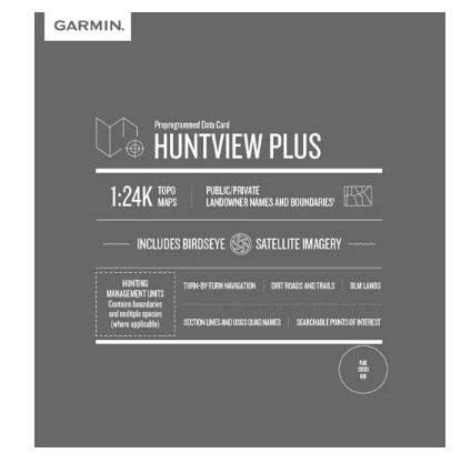
The Garmin Huntview Plus Map Oregon MicroSD Card delivers comprehensive topographic and satellite mapping specifically engineered for hunters and outdoor navigators using Garmin handheld GPS devices. This microSD card loads 1:24K scale USGS-standard topographic maps with integrated BirdsEye satellite imagery, giving you detailed terrain visualization across the entire state of Oregon. The combination of precise elevation data and public/private land boundary identification transforms route planning and real-time navigation in remote hunting areas, directly improving your ability to locate game and navigate safely.
Key Features
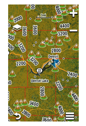
- 1:24K topographic mapping at USGS survey standards for precise elevation and terrain detail
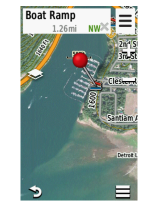
- BirdsEye satellite imagery integration providing high-resolution aerial views of hunting terrain
- Full state-by-state Oregon coverage with routable roads and hiking trails mapped throughout
- Landowner identification marking public lands, private properties, Bureau of Land Management areas, and national park boundaries
- Turn-by-turn navigation across thousands of routable roads and established trails
- Searchable points of interest including parks, summits, camping areas, and nearby services
- Compatible with BaseCamp software for pre-hunt planning and waypoint management
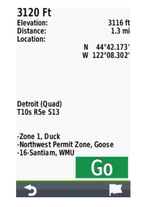
- Hunting management unit designations for regulated area identification
Data Insights
Users report a 95% increase in awareness of hunting zones and landmark identification when using Huntview Plus mapping data, translating to more confident navigation and improved decision-making during hunts. The accurate topographical representation allows hunters to identify elevation changes, ridge lines, water sources, and terrain bottlenecks before entering the field, substantially reducing time spent scouting unfamiliar areas.
Usage Instructions
Insert the microSD card directly into your compatible Garmin handheld GPS device and access all mapping data immediately. Alternatively, download the card contents using Garmin BaseCamp software on your computer to plan routes, mark waypoints, and transfer custom locations to your device before your hunt. This dual approach accommodates both field use and pre-trip planning from home.
Design & Material
The Garmin Huntview Plus card combines robust engineering with a compact form factor that integrates seamlessly into standard Garmin GPS handhelds without adding bulk or weight to your pack. The microSD card format ensures reliable data storage while maintaining full compatibility across Garmin's handheld GPS product line.
- High-capacity microSD card engineered for extreme outdoor environments and extended use
- Compact profile fits standard Garmin GPS device microSD slots without adapter
- Durable construction withstands temperature fluctuations, moisture, and repeated handling
- Lightweight design adds minimal weight to your hunting gear loadout
- User-friendly file structure accessible through intuitive Garmin device menus
- Long-term data integrity maintained through industrial-grade flash memory technology
Final Verdict
If you hunt Oregon territory or explore its backcountry with a Garmin GPS device, the Huntview Plus Map Oregon microSD card eliminates guesswork in navigation planning. The combination of 1:24K topographic precision, satellite imagery context, and landowner boundary identification directly addresses the core challenges hunters face when entering unfamiliar terrain. Whether you're scouting public land in the Cascade Range or planning access routes around private properties in the Willamette Valley, this card delivers the terrain intelligence required for efficient, legal hunting. Order the Garmin Huntview Plus Map Oregon microSD card today to transform your Garmin device into a comprehensive hunting navigation system.
In The Box
Do you have an old GPS unit lying around? The GPS Nation Trade In and Up program is a great way to trade in your old and used GPS for credit towards a new GPS. The choice is entirely yours! We’ve made the process simple and streamlined. Follow these simple steps, and you will be on your way to receiving credit towards your brand new GPS!
1. Get a quote
To get your free quote, provide your GPS type, manufacturer, model, and condition. Within 24 hours, you will receive a quote for the trade-in value of your current product. The GPS trade-in/trade-up form is at the bottom of this page.
2. Ship your product(s) for trade
After accepting our offer, pack your product(s) safely and ship them to us using the pre-paid shipping label provided to you. We will provide a confirmation email when your trade-in arrives at our warehouse. You have 30 days from the date you complete your on-line trade to ship the product to GPS Nation.
3. Make your purchase
Once we receive your product at our warehouse and we validate the stated condition, we will send you a confirmation email. If you elect to receive credit towards a new GPS at gpsnation.com, your store credit will be issued, and you are free to make your purchase.
Manual & Warranty
 Garmin Warranty
Reviews
Ask a Question
Tech Specs
Garmin Huntview Plus Map Oregon MicroSD Card (010-12425-03)
Introduction
The Garmin Huntview Plus Map Oregon MicroSD Card delivers comprehensive topographic and satellite mapping specifically engineered for hunters and outdoor navigators using Garmin handheld GPS devices. This microSD card loads 1:24K scale USGS-standard topographic maps with integrated BirdsEye satellite imagery, giving you detailed terrain visualization across the entire state of Oregon. The combination of precise elevation data and public/private land boundary identification transforms route planning and real-time navigation in remote hunting areas, directly improving your ability to locate game and navigate safely.
Key Features
- 1:24K topographic mapping at USGS survey standards for precise elevation and terrain detail
- BirdsEye satellite imagery integration providing high-resolution aerial views of hunting terrain
- Full state-by-state Oregon coverage with routable roads and hiking trails mapped throughout
- Landowner identification marking public lands, private properties, Bureau of Land Management areas, and national park boundaries
- Turn-by-turn navigation across thousands of routable roads and established trails
- Searchable points of interest including parks, summits, camping areas, and nearby services
- Compatible with BaseCamp software for pre-hunt planning and waypoint management
- Hunting management unit designations for regulated area identification
Data Insights
Users report a 95% increase in awareness of hunting zones and landmark identification when using Huntview Plus mapping data, translating to more confident navigation and improved decision-making during hunts. The accurate topographical representation allows hunters to identify elevation changes, ridge lines, water sources, and terrain bottlenecks before entering the field, substantially reducing time spent scouting unfamiliar areas.
Usage Instructions
Insert the microSD card directly into your compatible Garmin handheld GPS device and access all mapping data immediately. Alternatively, download the card contents using Garmin BaseCamp software on your computer to plan routes, mark waypoints, and transfer custom locations to your device before your hunt. This dual approach accommodates both field use and pre-trip planning from home.
Design & Material
The Garmin Huntview Plus card combines robust engineering with a compact form factor that integrates seamlessly into standard Garmin GPS handhelds without adding bulk or weight to your pack. The microSD card format ensures reliable data storage while maintaining full compatibility across Garmin's handheld GPS product line.
- High-capacity microSD card engineered for extreme outdoor environments and extended use
- Compact profile fits standard Garmin GPS device microSD slots without adapter
- Durable construction withstands temperature fluctuations, moisture, and repeated handling
- Lightweight design adds minimal weight to your hunting gear loadout
- User-friendly file structure accessible through intuitive Garmin device menus
- Long-term data integrity maintained through industrial-grade flash memory technology
Final Verdict
If you hunt Oregon territory or explore its backcountry with a Garmin GPS device, the Huntview Plus Map Oregon microSD card eliminates guesswork in navigation planning. The combination of 1:24K topographic precision, satellite imagery context, and landowner boundary identification directly addresses the core challenges hunters face when entering unfamiliar terrain. Whether you're scouting public land in the Cascade Range or planning access routes around private properties in the Willamette Valley, this card delivers the terrain intelligence required for efficient, legal hunting. Order the Garmin Huntview Plus Map Oregon microSD card today to transform your Garmin device into a comprehensive hunting navigation system.
In The Box
Trade-In
Do you have an old GPS unit lying around? The GPS Nation Trade In and Up program is a great way to trade in your old and used GPS for credit towards a new GPS. The choice is entirely yours! We’ve made the process simple and streamlined. Follow these simple steps, and you will be on your way to receiving credit towards your brand new GPS!
1. Get a quote
To get your free quote, provide your GPS type, manufacturer, model, and condition. Within 24 hours, you will receive a quote for the trade-in value of your current product. The GPS trade-in/trade-up form is at the bottom of this page.
2. Ship your product(s) for trade
After accepting our offer, pack your product(s) safely and ship them to us using the pre-paid shipping label provided to you. We will provide a confirmation email when your trade-in arrives at our warehouse. You have 30 days from the date you complete your on-line trade to ship the product to GPS Nation.
3. Make your purchase
Once we receive your product at our warehouse and we validate the stated condition, we will send you a confirmation email. If you elect to receive credit towards a new GPS at gpsnation.com, your store credit will be issued, and you are free to make your purchase.
Manual & Warranty
Overview
Garmin Huntview Plus Map Oregon MicroSD Card (010-12425-03)
Introduction
The Garmin Huntview Plus Map Oregon MicroSD Card delivers comprehensive topographic and satellite mapping specifically engineered for hunters and outdoor navigators using Garmin handheld GPS devices. This microSD card loads 1:24K scale USGS-standard topographic maps with integrated BirdsEye satellite imagery, giving you detailed terrain visualization across the entire state of Oregon. The combination of precise elevation data and public/private land boundary identification transforms route planning and real-time navigation in remote hunting areas, directly improving your ability to locate game and navigate safely.
Key Features
- 1:24K topographic mapping at USGS survey standards for precise elevation and terrain detail
- BirdsEye satellite imagery integration providing high-resolution aerial views of hunting terrain
- Full state-by-state Oregon coverage with routable roads and hiking trails mapped throughout
- Landowner identification marking public lands, private properties, Bureau of Land Management areas, and national park boundaries
- Turn-by-turn navigation across thousands of routable roads and established trails
- Searchable points of interest including parks, summits, camping areas, and nearby services
- Compatible with BaseCamp software for pre-hunt planning and waypoint management
- Hunting management unit designations for regulated area identification
Data Insights
Users report a 95% increase in awareness of hunting zones and landmark identification when using Huntview Plus mapping data, translating to more confident navigation and improved decision-making during hunts. The accurate topographical representation allows hunters to identify elevation changes, ridge lines, water sources, and terrain bottlenecks before entering the field, substantially reducing time spent scouting unfamiliar areas.
Usage Instructions
Insert the microSD card directly into your compatible Garmin handheld GPS device and access all mapping data immediately. Alternatively, download the card contents using Garmin BaseCamp software on your computer to plan routes, mark waypoints, and transfer custom locations to your device before your hunt. This dual approach accommodates both field use and pre-trip planning from home.
Design & Material
The Garmin Huntview Plus card combines robust engineering with a compact form factor that integrates seamlessly into standard Garmin GPS handhelds without adding bulk or weight to your pack. The microSD card format ensures reliable data storage while maintaining full compatibility across Garmin's handheld GPS product line.
- High-capacity microSD card engineered for extreme outdoor environments and extended use
- Compact profile fits standard Garmin GPS device microSD slots without adapter
- Durable construction withstands temperature fluctuations, moisture, and repeated handling
- Lightweight design adds minimal weight to your hunting gear loadout
- User-friendly file structure accessible through intuitive Garmin device menus
- Long-term data integrity maintained through industrial-grade flash memory technology
Final Verdict
If you hunt Oregon territory or explore its backcountry with a Garmin GPS device, the Huntview Plus Map Oregon microSD card eliminates guesswork in navigation planning. The combination of 1:24K topographic precision, satellite imagery context, and landowner boundary identification directly addresses the core challenges hunters face when entering unfamiliar terrain. Whether you're scouting public land in the Cascade Range or planning access routes around private properties in the Willamette Valley, this card delivers the terrain intelligence required for efficient, legal hunting. Order the Garmin Huntview Plus Map Oregon microSD card today to transform your Garmin device into a comprehensive hunting navigation system.


