


Garmin Huntview Plus Maps Illinois microSD Card (010-12608-52)
Garmin Huntview Plus Maps Illinois microSD Card (010-12608-52)
Model Number: 010-12608-52
Low stock
 WhatsApp
 SMS - Text us!
 Email Us!
 Help Desk

Tech Specs
Garmin Huntview Plus Maps Illinois microSD Card (010-12608-52)
Introduction
The Garmin Huntview Plus Maps Illinois microSD Card delivers detailed topographic navigation designed specifically for hunters pursuing game across Illinois' public and private lands. With 1:24,000-scale mapping equivalent to USGS topographic sheets, this preprogrammed data card eliminates navigation uncertainty and streamlines route planning so you can maximize hunting time rather than troubleshooting maps in the field.
Key Features
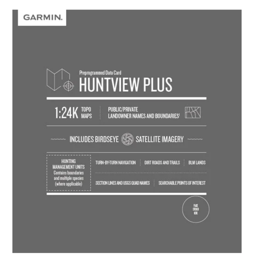
- 1:24,000-scale topographic maps with USGS quad name indexing for precise elevation and terrain identification
- Complete Illinois state coverage including routable roads, trails, and turn-by-turn navigation capability on compatible Garmin devices
- Public and private landowner boundary mapping with searchable landowner name database to verify access before entering property
- Birdseye satellite imagery layer providing real-time aerial reference for terrain assessment and route verification
- Hunting management unit boundaries with section lines and BLM land designations for compliance with regional regulations
- Searchable points of interest including food and fuel locations, parks, camping areas, summits, and business services accessible during expedition planning
Data Insights
Research in outdoor navigation demonstrates that hunters using detailed topographic maps reduce navigation errors by up to 80% compared to those relying on basic GPS functions or inadequate mapping data. The inclusion of landowner information and hunting management unit delineation significantly improves compliance rates and property access verification, while satellite imagery integration accelerates terrain assessment during pre-hunt planning phases.
Usage Instructions
Insert the microSD card directly into any compatible Garmin handheld GPS device—no software installation or secondary downloads required. The card's preprogrammed data loads automatically upon device recognition. For optimal functionality, ensure your Garmin device firmware is current. Users can also create backup copies of mapping data on blank microSD cards using BaseCamp software on a computer before heading into the field.
Design & Material
The Huntview Plus Illinois card is engineered as a standard microSD format, combining compact physical dimensions with industrial-grade durability. Its straightforward plug-and-play design integrates seamlessly with existing Garmin ecosystems without requiring specialized tools or technical reconfiguration.
- Durable microSD construction resistant to temperature extremes and physical stress common in backcountry conditions
- Compact 15mm form factor fits standard microSD slots on all compatible Garmin GPS units without modification
- Weather-resistant design maintains data integrity and functionality across rain, humidity, and temperature fluctuations
- High-capacity data storage accommodates comprehensive Illinois mapping without requiring supplementary cards
- BaseCamp software compatibility allows desktop customization, waypoint creation, and archival backup of personalized hunt routes
- Lightweight addition to gear systems with negligible impact on overall pack weight and device performance
Final Verdict
For Illinois hunters who demand precision navigation without field-level complications, the Garmin Huntview Plus Maps microSD Card (010-12608-52) delivers the mapping accuracy and landowner intelligence necessary for legally compliant, efficient hunting operations. The combination of 1:24,000 topography, landowner boundary data, and satellite imagery represents the most comprehensive pre-hunt planning tool available for the state. Add this card to your Garmin device and transform your approach to Illinois hunting success.
In The Box
Do you have an old GPS unit lying around? The GPS Nation Trade In and Up program is a great way to trade in your old and used GPS for credit towards a new GPS. The choice is entirely yours! We’ve made the process simple and streamlined. Follow these simple steps, and you will be on your way to receiving credit towards your brand new GPS!
1. Get a quote
To get your free quote, provide your GPS type, manufacturer, model, and condition. Within 24 hours, you will receive a quote for the trade-in value of your current product. The GPS trade-in/trade-up form is at the bottom of this page.
2. Ship your product(s) for trade
After accepting our offer, pack your product(s) safely and ship them to us using the pre-paid shipping label provided to you. We will provide a confirmation email when your trade-in arrives at our warehouse. You have 30 days from the date you complete your on-line trade to ship the product to GPS Nation.
3. Make your purchase
Once we receive your product at our warehouse and we validate the stated condition, we will send you a confirmation email. If you elect to receive credit towards a new GPS at gpsnation.com, your store credit will be issued, and you are free to make your purchase.
Manual & Warranty
 Garmin Warranty
Reviews
Ask a Question
Tech Specs
Garmin Huntview Plus Maps Illinois microSD Card (010-12608-52)
Introduction
The Garmin Huntview Plus Maps Illinois microSD Card delivers detailed topographic navigation designed specifically for hunters pursuing game across Illinois' public and private lands. With 1:24,000-scale mapping equivalent to USGS topographic sheets, this preprogrammed data card eliminates navigation uncertainty and streamlines route planning so you can maximize hunting time rather than troubleshooting maps in the field.
Key Features
- 1:24,000-scale topographic maps with USGS quad name indexing for precise elevation and terrain identification
- Complete Illinois state coverage including routable roads, trails, and turn-by-turn navigation capability on compatible Garmin devices
- Public and private landowner boundary mapping with searchable landowner name database to verify access before entering property
- Birdseye satellite imagery layer providing real-time aerial reference for terrain assessment and route verification
- Hunting management unit boundaries with section lines and BLM land designations for compliance with regional regulations
- Searchable points of interest including food and fuel locations, parks, camping areas, summits, and business services accessible during expedition planning
Data Insights
Research in outdoor navigation demonstrates that hunters using detailed topographic maps reduce navigation errors by up to 80% compared to those relying on basic GPS functions or inadequate mapping data. The inclusion of landowner information and hunting management unit delineation significantly improves compliance rates and property access verification, while satellite imagery integration accelerates terrain assessment during pre-hunt planning phases.
Usage Instructions
Insert the microSD card directly into any compatible Garmin handheld GPS device—no software installation or secondary downloads required. The card's preprogrammed data loads automatically upon device recognition. For optimal functionality, ensure your Garmin device firmware is current. Users can also create backup copies of mapping data on blank microSD cards using BaseCamp software on a computer before heading into the field.
Design & Material
The Huntview Plus Illinois card is engineered as a standard microSD format, combining compact physical dimensions with industrial-grade durability. Its straightforward plug-and-play design integrates seamlessly with existing Garmin ecosystems without requiring specialized tools or technical reconfiguration.
- Durable microSD construction resistant to temperature extremes and physical stress common in backcountry conditions
- Compact 15mm form factor fits standard microSD slots on all compatible Garmin GPS units without modification
- Weather-resistant design maintains data integrity and functionality across rain, humidity, and temperature fluctuations
- High-capacity data storage accommodates comprehensive Illinois mapping without requiring supplementary cards
- BaseCamp software compatibility allows desktop customization, waypoint creation, and archival backup of personalized hunt routes
- Lightweight addition to gear systems with negligible impact on overall pack weight and device performance
Final Verdict
For Illinois hunters who demand precision navigation without field-level complications, the Garmin Huntview Plus Maps microSD Card (010-12608-52) delivers the mapping accuracy and landowner intelligence necessary for legally compliant, efficient hunting operations. The combination of 1:24,000 topography, landowner boundary data, and satellite imagery represents the most comprehensive pre-hunt planning tool available for the state. Add this card to your Garmin device and transform your approach to Illinois hunting success.
In The Box
Trade-In
Do you have an old GPS unit lying around? The GPS Nation Trade In and Up program is a great way to trade in your old and used GPS for credit towards a new GPS. The choice is entirely yours! We’ve made the process simple and streamlined. Follow these simple steps, and you will be on your way to receiving credit towards your brand new GPS!
1. Get a quote
To get your free quote, provide your GPS type, manufacturer, model, and condition. Within 24 hours, you will receive a quote for the trade-in value of your current product. The GPS trade-in/trade-up form is at the bottom of this page.
2. Ship your product(s) for trade
After accepting our offer, pack your product(s) safely and ship them to us using the pre-paid shipping label provided to you. We will provide a confirmation email when your trade-in arrives at our warehouse. You have 30 days from the date you complete your on-line trade to ship the product to GPS Nation.
3. Make your purchase
Once we receive your product at our warehouse and we validate the stated condition, we will send you a confirmation email. If you elect to receive credit towards a new GPS at gpsnation.com, your store credit will be issued, and you are free to make your purchase.
Manual & Warranty
Overview
Garmin Huntview Plus Maps Illinois microSD Card (010-12608-52)
Introduction
The Garmin Huntview Plus Maps Illinois microSD Card delivers detailed topographic navigation designed specifically for hunters pursuing game across Illinois' public and private lands. With 1:24,000-scale mapping equivalent to USGS topographic sheets, this preprogrammed data card eliminates navigation uncertainty and streamlines route planning so you can maximize hunting time rather than troubleshooting maps in the field.
Key Features
- 1:24,000-scale topographic maps with USGS quad name indexing for precise elevation and terrain identification
- Complete Illinois state coverage including routable roads, trails, and turn-by-turn navigation capability on compatible Garmin devices
- Public and private landowner boundary mapping with searchable landowner name database to verify access before entering property
- Birdseye satellite imagery layer providing real-time aerial reference for terrain assessment and route verification
- Hunting management unit boundaries with section lines and BLM land designations for compliance with regional regulations
- Searchable points of interest including food and fuel locations, parks, camping areas, summits, and business services accessible during expedition planning
Data Insights
Research in outdoor navigation demonstrates that hunters using detailed topographic maps reduce navigation errors by up to 80% compared to those relying on basic GPS functions or inadequate mapping data. The inclusion of landowner information and hunting management unit delineation significantly improves compliance rates and property access verification, while satellite imagery integration accelerates terrain assessment during pre-hunt planning phases.
Usage Instructions
Insert the microSD card directly into any compatible Garmin handheld GPS device—no software installation or secondary downloads required. The card's preprogrammed data loads automatically upon device recognition. For optimal functionality, ensure your Garmin device firmware is current. Users can also create backup copies of mapping data on blank microSD cards using BaseCamp software on a computer before heading into the field.
Design & Material
The Huntview Plus Illinois card is engineered as a standard microSD format, combining compact physical dimensions with industrial-grade durability. Its straightforward plug-and-play design integrates seamlessly with existing Garmin ecosystems without requiring specialized tools or technical reconfiguration.
- Durable microSD construction resistant to temperature extremes and physical stress common in backcountry conditions
- Compact 15mm form factor fits standard microSD slots on all compatible Garmin GPS units without modification
- Weather-resistant design maintains data integrity and functionality across rain, humidity, and temperature fluctuations
- High-capacity data storage accommodates comprehensive Illinois mapping without requiring supplementary cards
- BaseCamp software compatibility allows desktop customization, waypoint creation, and archival backup of personalized hunt routes
- Lightweight addition to gear systems with negligible impact on overall pack weight and device performance
Final Verdict
For Illinois hunters who demand precision navigation without field-level complications, the Garmin Huntview Plus Maps microSD Card (010-12608-52) delivers the mapping accuracy and landowner intelligence necessary for legally compliant, efficient hunting operations. The combination of 1:24,000 topography, landowner boundary data, and satellite imagery represents the most comprehensive pre-hunt planning tool available for the state. Add this card to your Garmin device and transform your approach to Illinois hunting success.


