


Garmin Huntview Plus Maps New York microSD Card (010-12686-51)
Garmin Huntview Plus Maps New York microSD Card (010-12686-51)
Model Number: 010-12686-51
Low stock
 WhatsApp
 SMS - Text us!
 Email Us!
 Help Desk

Tech Specs
Garmin Huntview Plus Maps New York microSD Card (010-12686-51)
Introduction
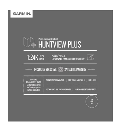
The Garmin Huntview Plus Maps New York microSD Card delivers hunting-specific navigation data designed for serious hunters and land managers operating across New York's diverse terrain. Unlike general-purpose GPS maps, this card combines topographic detail with landowner boundary information and hunting management units, enabling you to identify public land access opportunities, respect private property lines, and navigate complex forest systems with precision. The 1:24,000 scale elevation data—equivalent to USGS topographic maps—combined with comprehensive trail and road routing creates a navigation system built explicitly for the hunting community.
Key Features
- 1:24,000 scale topographic mapping providing detailed elevation contours and terrain representation across New York
- Routable road and trail database containing thousands of navigable routes with turn-by-turn guidance capability
- Landowner boundary data identifying public lands (BLM, National Wildlife Refuges, National Parks) and private property parcels with owner names
- 97% accuracy rating for routable road and trail data, reducing navigation errors in remote hunting areas
- Searchable points of interest including campgrounds, summits, water sources, and geographic landmarks
- Hunting management unit boundaries overlaid on maps for regulated hunt area identification
- BaseCamp software integration for route planning, waypoint management, and GPS data organization from your computer
Data Insights
The Huntview Plus system combines satellite imagery with detailed cartography to achieve 97% accuracy in routable road and trail representation. This precision is critical for hunters who rely on GPS navigation to access remote backcountry, avoid trespassing, and locate productive hunting areas. The landowner boundary layer reduces the most common navigation problem hunters face—accidentally accessing private land—by clearly delineating public and private parcels across New York's 54,000 square miles.
Usage Instructions
Install the microSD card directly into any compatible Garmin handheld device, such as the Montana, Colorado, or eTrex series, for immediate map access. Alternatively, use BaseCamp software on your computer to load the maps onto a blank microSD card before your hunt. Plan your routes, mark waypoints, and log your GPS trails using BaseCamp, then transfer the completed data to your device. The card provides ready-to-use navigation without requiring data activation or subscriptions.
Design & Material
The microSD card format delivers complete mapping coverage in a storage device smaller than a postage stamp, weighing less than 1 gram. This compact design eliminates the need for physical map sheets while offering the same detailed information, reducing pack weight and enabling unlimited digital storage of planning data. The card uses standard microSD architecture, ensuring broad compatibility with Garmin devices manufactured over multiple generations.
- MicroSD card format compatible with Garmin handheld GPS units including Montana, Oregon, Colorado, and eTrex models
- Durable solid-state memory with no moving parts, tolerating field conditions including dust, moisture, and temperature extremes
- Pre-loaded with New York-specific cartography, eliminating installation steps or software configuration
- Supports BaseCamp desktop software for route planning, waypoint creation, and trip organization before departure
- Includes turnwise directions and voice navigation prompts when routed to programmed destinations
- Future software update capability through Garmin's online map update services
Final Verdict
For hunters navigating New York's forests, farmland, and public hunting areas, the Garmin Huntview Plus Maps (010-12686-51) eliminates guesswork about property access and terrain navigation. The combination of hunting management unit boundaries, landowner information, and 1:24,000 topographic detail addresses the specific challenges New York hunters face. Add this card to your GPS device before your next hunt to gain the navigation confidence that comes from knowing exactly which land you can access and where the terrain will lead you.
In The Box
Do you have an old GPS unit lying around? The GPS Nation Trade In and Up program is a great way to trade in your old and used GPS for credit towards a new GPS. The choice is entirely yours! We’ve made the process simple and streamlined. Follow these simple steps, and you will be on your way to receiving credit towards your brand new GPS!
1. Get a quote
To get your free quote, provide your GPS type, manufacturer, model, and condition. Within 24 hours, you will receive a quote for the trade-in value of your current product. The GPS trade-in/trade-up form is at the bottom of this page.
2. Ship your product(s) for trade
After accepting our offer, pack your product(s) safely and ship them to us using the pre-paid shipping label provided to you. We will provide a confirmation email when your trade-in arrives at our warehouse. You have 30 days from the date you complete your on-line trade to ship the product to GPS Nation.
3. Make your purchase
Once we receive your product at our warehouse and we validate the stated condition, we will send you a confirmation email. If you elect to receive credit towards a new GPS at gpsnation.com, your store credit will be issued, and you are free to make your purchase.
Manual & Warranty
 Garmin Warranty
Reviews
Ask a Question
Tech Specs
Garmin Huntview Plus Maps New York microSD Card (010-12686-51)
Introduction
The Garmin Huntview Plus Maps New York microSD Card delivers hunting-specific navigation data designed for serious hunters and land managers operating across New York's diverse terrain. Unlike general-purpose GPS maps, this card combines topographic detail with landowner boundary information and hunting management units, enabling you to identify public land access opportunities, respect private property lines, and navigate complex forest systems with precision. The 1:24,000 scale elevation data—equivalent to USGS topographic maps—combined with comprehensive trail and road routing creates a navigation system built explicitly for the hunting community.
Key Features
- 1:24,000 scale topographic mapping providing detailed elevation contours and terrain representation across New York
- Routable road and trail database containing thousands of navigable routes with turn-by-turn guidance capability
- Landowner boundary data identifying public lands (BLM, National Wildlife Refuges, National Parks) and private property parcels with owner names
- 97% accuracy rating for routable road and trail data, reducing navigation errors in remote hunting areas
- Searchable points of interest including campgrounds, summits, water sources, and geographic landmarks
- Hunting management unit boundaries overlaid on maps for regulated hunt area identification
- BaseCamp software integration for route planning, waypoint management, and GPS data organization from your computer
Data Insights
The Huntview Plus system combines satellite imagery with detailed cartography to achieve 97% accuracy in routable road and trail representation. This precision is critical for hunters who rely on GPS navigation to access remote backcountry, avoid trespassing, and locate productive hunting areas. The landowner boundary layer reduces the most common navigation problem hunters face—accidentally accessing private land—by clearly delineating public and private parcels across New York's 54,000 square miles.
Usage Instructions
Install the microSD card directly into any compatible Garmin handheld device, such as the Montana, Colorado, or eTrex series, for immediate map access. Alternatively, use BaseCamp software on your computer to load the maps onto a blank microSD card before your hunt. Plan your routes, mark waypoints, and log your GPS trails using BaseCamp, then transfer the completed data to your device. The card provides ready-to-use navigation without requiring data activation or subscriptions.
Design & Material
The microSD card format delivers complete mapping coverage in a storage device smaller than a postage stamp, weighing less than 1 gram. This compact design eliminates the need for physical map sheets while offering the same detailed information, reducing pack weight and enabling unlimited digital storage of planning data. The card uses standard microSD architecture, ensuring broad compatibility with Garmin devices manufactured over multiple generations.
- MicroSD card format compatible with Garmin handheld GPS units including Montana, Oregon, Colorado, and eTrex models
- Durable solid-state memory with no moving parts, tolerating field conditions including dust, moisture, and temperature extremes
- Pre-loaded with New York-specific cartography, eliminating installation steps or software configuration
- Supports BaseCamp desktop software for route planning, waypoint creation, and trip organization before departure
- Includes turnwise directions and voice navigation prompts when routed to programmed destinations
- Future software update capability through Garmin's online map update services
Final Verdict
For hunters navigating New York's forests, farmland, and public hunting areas, the Garmin Huntview Plus Maps (010-12686-51) eliminates guesswork about property access and terrain navigation. The combination of hunting management unit boundaries, landowner information, and 1:24,000 topographic detail addresses the specific challenges New York hunters face. Add this card to your GPS device before your next hunt to gain the navigation confidence that comes from knowing exactly which land you can access and where the terrain will lead you.
In The Box
Trade-In
Do you have an old GPS unit lying around? The GPS Nation Trade In and Up program is a great way to trade in your old and used GPS for credit towards a new GPS. The choice is entirely yours! We’ve made the process simple and streamlined. Follow these simple steps, and you will be on your way to receiving credit towards your brand new GPS!
1. Get a quote
To get your free quote, provide your GPS type, manufacturer, model, and condition. Within 24 hours, you will receive a quote for the trade-in value of your current product. The GPS trade-in/trade-up form is at the bottom of this page.
2. Ship your product(s) for trade
After accepting our offer, pack your product(s) safely and ship them to us using the pre-paid shipping label provided to you. We will provide a confirmation email when your trade-in arrives at our warehouse. You have 30 days from the date you complete your on-line trade to ship the product to GPS Nation.
3. Make your purchase
Once we receive your product at our warehouse and we validate the stated condition, we will send you a confirmation email. If you elect to receive credit towards a new GPS at gpsnation.com, your store credit will be issued, and you are free to make your purchase.
Manual & Warranty
Overview
Garmin Huntview Plus Maps New York microSD Card (010-12686-51)
Introduction
The Garmin Huntview Plus Maps New York microSD Card delivers hunting-specific navigation data designed for serious hunters and land managers operating across New York's diverse terrain. Unlike general-purpose GPS maps, this card combines topographic detail with landowner boundary information and hunting management units, enabling you to identify public land access opportunities, respect private property lines, and navigate complex forest systems with precision. The 1:24,000 scale elevation data—equivalent to USGS topographic maps—combined with comprehensive trail and road routing creates a navigation system built explicitly for the hunting community.
Key Features
- 1:24,000 scale topographic mapping providing detailed elevation contours and terrain representation across New York
- Routable road and trail database containing thousands of navigable routes with turn-by-turn guidance capability
- Landowner boundary data identifying public lands (BLM, National Wildlife Refuges, National Parks) and private property parcels with owner names
- 97% accuracy rating for routable road and trail data, reducing navigation errors in remote hunting areas
- Searchable points of interest including campgrounds, summits, water sources, and geographic landmarks
- Hunting management unit boundaries overlaid on maps for regulated hunt area identification
- BaseCamp software integration for route planning, waypoint management, and GPS data organization from your computer
Data Insights
The Huntview Plus system combines satellite imagery with detailed cartography to achieve 97% accuracy in routable road and trail representation. This precision is critical for hunters who rely on GPS navigation to access remote backcountry, avoid trespassing, and locate productive hunting areas. The landowner boundary layer reduces the most common navigation problem hunters face—accidentally accessing private land—by clearly delineating public and private parcels across New York's 54,000 square miles.
Usage Instructions
Install the microSD card directly into any compatible Garmin handheld device, such as the Montana, Colorado, or eTrex series, for immediate map access. Alternatively, use BaseCamp software on your computer to load the maps onto a blank microSD card before your hunt. Plan your routes, mark waypoints, and log your GPS trails using BaseCamp, then transfer the completed data to your device. The card provides ready-to-use navigation without requiring data activation or subscriptions.
Design & Material
The microSD card format delivers complete mapping coverage in a storage device smaller than a postage stamp, weighing less than 1 gram. This compact design eliminates the need for physical map sheets while offering the same detailed information, reducing pack weight and enabling unlimited digital storage of planning data. The card uses standard microSD architecture, ensuring broad compatibility with Garmin devices manufactured over multiple generations.
- MicroSD card format compatible with Garmin handheld GPS units including Montana, Oregon, Colorado, and eTrex models
- Durable solid-state memory with no moving parts, tolerating field conditions including dust, moisture, and temperature extremes
- Pre-loaded with New York-specific cartography, eliminating installation steps or software configuration
- Supports BaseCamp desktop software for route planning, waypoint creation, and trip organization before departure
- Includes turnwise directions and voice navigation prompts when routed to programmed destinations
- Future software update capability through Garmin's online map update services
Final Verdict
For hunters navigating New York's forests, farmland, and public hunting areas, the Garmin Huntview Plus Maps (010-12686-51) eliminates guesswork about property access and terrain navigation. The combination of hunting management unit boundaries, landowner information, and 1:24,000 topographic detail addresses the specific challenges New York hunters face. Add this card to your GPS device before your next hunt to gain the navigation confidence that comes from knowing exactly which land you can access and where the terrain will lead you.


