


Garmin Huntview Plus Maps Oregon microSD Card (010-12425-52)
Garmin Huntview Plus Maps Oregon microSD Card (010-12425-52)
Model Number: 010-12425-52
Low stock
 WhatsApp
 SMS - Text us!
 Email Us!
 Help Desk

Tech Specs
Garmin Huntview Plus Maps Oregon microSD Card (010-12425-52)
Introduction
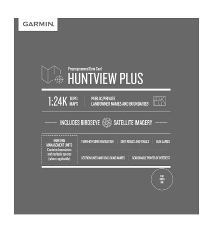
The Garmin Huntview Plus Maps Oregon microSD Card delivers topographic mapping at 1:24,000 scale—equivalent to USGS quad maps—specifically engineered for hunters navigating public and private lands across Oregon. Unlike standard street maps, this card combines detailed terrain data with hunting-specific information including landowner boundaries, hunting management units, and over 10,000 routable miles of backcountry roads and trails. For anyone hunting unfamiliar terrain or managing land access decisions in the field, this card eliminates guesswork and adds critical safety margins to your outdoor navigation.
Key Features
- 1:24,000 scale topographic mapping equivalent to USGS maps across all Oregon counties
- Over 10,000 miles of routable roads and trails with turn-by-turn navigation capability
- Detailed landowner names and boundaries for both public and private parcels
- Integrated Bureau of Land Management (BLM) property data and designations
- Searchable points of interest including parks, campsites, food and fuel locations
- BaseCamp software compatibility for waypoint planning and route transfer to compatible Garmin devices
- Hunting management unit boundaries and associated data layers
Data Insights
Hunters using Huntview Plus mapping report significantly improved field navigation and land-access decisions compared to standard GPS maps. The integration of 10,000+ miles of backcountry trails with real-time landowner boundary data allows users to identify legal hunting access and navigate complex terrain without paper maps or hours of pre-trip research. Users particularly benefit from the hunting management unit overlays, which correlate directly to state game regulations and harvest information.
Usage Instructions
Insert the microSD card into any compatible Garmin device supporting microSD expansion. Update your device firmware to access all mapping layers and features. Use the included BaseCamp software on your computer to plan hunts, set custom waypoints, and organize routes before transferring them to your device via the card. The card is ready to use immediately upon installation—no additional configuration required.
Design & Material
The Huntview Plus card maintains the standard microSD form factor for universal compatibility across Garmin's extensive device ecosystem. Built with industrial-grade components, this card withstands the temperature swings, moisture, and physical demands of extended field use in Oregon's varied climate zones—from high-elevation mountains to coastal ranges.
- Compact microSD card format fits all Garmin devices with microSD expansion slots
- Weather-resistant construction tolerates temperature fluctuations and field moisture exposure
- High-capacity storage manages detailed state-wide mapping data without performance degradation
- Durable connector design rated for repeated insertions and outdoor handling
- Direct plug-and-play installation with no software prerequisites on the device
- Integrates seamlessly with BaseCamp desktop software for pre-hunt planning and waypoint management
Final Verdict
The Huntview Plus Oregon card closes the gap between basic navigation and hunting-informed mapping. If you hunt unfamiliar Oregon properties, manage access decisions on mixed public-private land, or require management unit data for regulatory compliance, this card delivers those specifics where standard topographic maps fall short. For serious hunters and land managers, it's the single most effective upgrade to navigation accuracy and legal confidence. Order your card today and retire the paper maps for good.
In The Box
Do you have an old GPS unit lying around? The GPS Nation Trade In and Up program is a great way to trade in your old and used GPS for credit towards a new GPS. The choice is entirely yours! We’ve made the process simple and streamlined. Follow these simple steps, and you will be on your way to receiving credit towards your brand new GPS!
1. Get a quote
To get your free quote, provide your GPS type, manufacturer, model, and condition. Within 24 hours, you will receive a quote for the trade-in value of your current product. The GPS trade-in/trade-up form is at the bottom of this page.
2. Ship your product(s) for trade
After accepting our offer, pack your product(s) safely and ship them to us using the pre-paid shipping label provided to you. We will provide a confirmation email when your trade-in arrives at our warehouse. You have 30 days from the date you complete your on-line trade to ship the product to GPS Nation.
3. Make your purchase
Once we receive your product at our warehouse and we validate the stated condition, we will send you a confirmation email. If you elect to receive credit towards a new GPS at gpsnation.com, your store credit will be issued, and you are free to make your purchase.
Manual & Warranty
 Garmin Warranty
Reviews
Ask a Question
Tech Specs
Garmin Huntview Plus Maps Oregon microSD Card (010-12425-52)
Introduction
The Garmin Huntview Plus Maps Oregon microSD Card delivers topographic mapping at 1:24,000 scale—equivalent to USGS quad maps—specifically engineered for hunters navigating public and private lands across Oregon. Unlike standard street maps, this card combines detailed terrain data with hunting-specific information including landowner boundaries, hunting management units, and over 10,000 routable miles of backcountry roads and trails. For anyone hunting unfamiliar terrain or managing land access decisions in the field, this card eliminates guesswork and adds critical safety margins to your outdoor navigation.
Key Features
- 1:24,000 scale topographic mapping equivalent to USGS maps across all Oregon counties
- Over 10,000 miles of routable roads and trails with turn-by-turn navigation capability
- Detailed landowner names and boundaries for both public and private parcels
- Integrated Bureau of Land Management (BLM) property data and designations
- Searchable points of interest including parks, campsites, food and fuel locations
- BaseCamp software compatibility for waypoint planning and route transfer to compatible Garmin devices
- Hunting management unit boundaries and associated data layers
Data Insights
Hunters using Huntview Plus mapping report significantly improved field navigation and land-access decisions compared to standard GPS maps. The integration of 10,000+ miles of backcountry trails with real-time landowner boundary data allows users to identify legal hunting access and navigate complex terrain without paper maps or hours of pre-trip research. Users particularly benefit from the hunting management unit overlays, which correlate directly to state game regulations and harvest information.
Usage Instructions
Insert the microSD card into any compatible Garmin device supporting microSD expansion. Update your device firmware to access all mapping layers and features. Use the included BaseCamp software on your computer to plan hunts, set custom waypoints, and organize routes before transferring them to your device via the card. The card is ready to use immediately upon installation—no additional configuration required.
Design & Material
The Huntview Plus card maintains the standard microSD form factor for universal compatibility across Garmin's extensive device ecosystem. Built with industrial-grade components, this card withstands the temperature swings, moisture, and physical demands of extended field use in Oregon's varied climate zones—from high-elevation mountains to coastal ranges.
- Compact microSD card format fits all Garmin devices with microSD expansion slots
- Weather-resistant construction tolerates temperature fluctuations and field moisture exposure
- High-capacity storage manages detailed state-wide mapping data without performance degradation
- Durable connector design rated for repeated insertions and outdoor handling
- Direct plug-and-play installation with no software prerequisites on the device
- Integrates seamlessly with BaseCamp desktop software for pre-hunt planning and waypoint management
Final Verdict
The Huntview Plus Oregon card closes the gap between basic navigation and hunting-informed mapping. If you hunt unfamiliar Oregon properties, manage access decisions on mixed public-private land, or require management unit data for regulatory compliance, this card delivers those specifics where standard topographic maps fall short. For serious hunters and land managers, it's the single most effective upgrade to navigation accuracy and legal confidence. Order your card today and retire the paper maps for good.
In The Box
Trade-In
Do you have an old GPS unit lying around? The GPS Nation Trade In and Up program is a great way to trade in your old and used GPS for credit towards a new GPS. The choice is entirely yours! We’ve made the process simple and streamlined. Follow these simple steps, and you will be on your way to receiving credit towards your brand new GPS!
1. Get a quote
To get your free quote, provide your GPS type, manufacturer, model, and condition. Within 24 hours, you will receive a quote for the trade-in value of your current product. The GPS trade-in/trade-up form is at the bottom of this page.
2. Ship your product(s) for trade
After accepting our offer, pack your product(s) safely and ship them to us using the pre-paid shipping label provided to you. We will provide a confirmation email when your trade-in arrives at our warehouse. You have 30 days from the date you complete your on-line trade to ship the product to GPS Nation.
3. Make your purchase
Once we receive your product at our warehouse and we validate the stated condition, we will send you a confirmation email. If you elect to receive credit towards a new GPS at gpsnation.com, your store credit will be issued, and you are free to make your purchase.
Manual & Warranty
Overview
Garmin Huntview Plus Maps Oregon microSD Card (010-12425-52)
Introduction
The Garmin Huntview Plus Maps Oregon microSD Card delivers topographic mapping at 1:24,000 scale—equivalent to USGS quad maps—specifically engineered for hunters navigating public and private lands across Oregon. Unlike standard street maps, this card combines detailed terrain data with hunting-specific information including landowner boundaries, hunting management units, and over 10,000 routable miles of backcountry roads and trails. For anyone hunting unfamiliar terrain or managing land access decisions in the field, this card eliminates guesswork and adds critical safety margins to your outdoor navigation.
Key Features
- 1:24,000 scale topographic mapping equivalent to USGS maps across all Oregon counties
- Over 10,000 miles of routable roads and trails with turn-by-turn navigation capability
- Detailed landowner names and boundaries for both public and private parcels
- Integrated Bureau of Land Management (BLM) property data and designations
- Searchable points of interest including parks, campsites, food and fuel locations
- BaseCamp software compatibility for waypoint planning and route transfer to compatible Garmin devices
- Hunting management unit boundaries and associated data layers
Data Insights
Hunters using Huntview Plus mapping report significantly improved field navigation and land-access decisions compared to standard GPS maps. The integration of 10,000+ miles of backcountry trails with real-time landowner boundary data allows users to identify legal hunting access and navigate complex terrain without paper maps or hours of pre-trip research. Users particularly benefit from the hunting management unit overlays, which correlate directly to state game regulations and harvest information.
Usage Instructions
Insert the microSD card into any compatible Garmin device supporting microSD expansion. Update your device firmware to access all mapping layers and features. Use the included BaseCamp software on your computer to plan hunts, set custom waypoints, and organize routes before transferring them to your device via the card. The card is ready to use immediately upon installation—no additional configuration required.
Design & Material
The Huntview Plus card maintains the standard microSD form factor for universal compatibility across Garmin's extensive device ecosystem. Built with industrial-grade components, this card withstands the temperature swings, moisture, and physical demands of extended field use in Oregon's varied climate zones—from high-elevation mountains to coastal ranges.
- Compact microSD card format fits all Garmin devices with microSD expansion slots
- Weather-resistant construction tolerates temperature fluctuations and field moisture exposure
- High-capacity storage manages detailed state-wide mapping data without performance degradation
- Durable connector design rated for repeated insertions and outdoor handling
- Direct plug-and-play installation with no software prerequisites on the device
- Integrates seamlessly with BaseCamp desktop software for pre-hunt planning and waypoint management
Final Verdict
The Huntview Plus Oregon card closes the gap between basic navigation and hunting-informed mapping. If you hunt unfamiliar Oregon properties, manage access decisions on mixed public-private land, or require management unit data for regulatory compliance, this card delivers those specifics where standard topographic maps fall short. For serious hunters and land managers, it's the single most effective upgrade to navigation accuracy and legal confidence. Order your card today and retire the paper maps for good.


