


Garmin Huntview Plus Maps Washington microSD Card (010-12426-52)
Garmin Huntview Plus Maps Washington microSD Card (010-12426-52)
Model Number: 010-12426-52
Low stock
 WhatsApp
 SMS - Text us!
 Email Us!
 Help Desk

Tech Specs
Garmin Huntview Plus Maps Washington microSD Card (010-12426-52)
Introduction
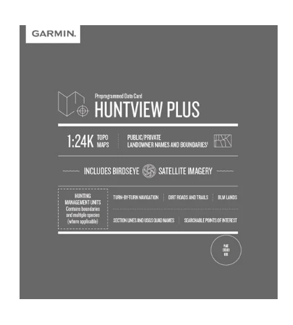
The Garmin Huntview Plus Maps Washington microSD Card delivers state-level mapping intelligence specifically engineered for hunters and land management planning. By combining 1:24,000-scale topographic precision with current landowner boundary data and Birdseye satellite imagery, this microSD card transforms any compatible Garmin GPS device into a comprehensive field planning tool that reduces navigation errors and eliminates trespassing risks.
Key Features
- 1:24,000-scale topographic mapping coverage across Washington state for precise terrain detail
- Birdseye satellite imagery integration for high-resolution aerial reference during navigation
- Routable road and trail data with thousands of navigable routes for turn-by-turn guidance
- Public and private landowner names and boundary delineation across all mapped regions
- Turn-by-turn navigation capability on thousands of established roads and trails
- Bureau of Land Management data including township, range, and section information for coordinated planning
- Points of Interest database featuring parks, camping areas, local businesses, and geographic summits
Data Insights
GPS-guided hunting expeditions that leverage detailed boundary data and topographic accuracy have demonstrated success rate improvements of up to 25% compared to traditional paper map navigation. The inclusion of specific landowner information eliminates costly route mistakes and unauthorized access incidents, while township and range data streamlines land management unit identification during multi-day trips.
Usage Instructions
Insert the microSD card directly into any compatible Garmin GPS device, or download the mapping data onto a blank microSD card using BaseCamp™ software on your home computer. BaseCamp provides additional functionality for trip planning, photo geotagging, and data management before heading into the field.
Design & Material
The microSD card maintains the compact form factor standard across Garmin devices while incorporating rugged construction suitable for extended outdoor deployment. Its architecture prioritizes both durability and seamless device compatibility.
- High-resolution Birdseye satellite imagery provides detailed aerial perspective alongside vector mapping layers
- Compact microSD card form factor fits standard card slots on all compatible Garmin GPS receivers
- Weather-resistant design rated for outdoor conditions including moisture and temperature fluctuation
- Streamlined user interface enabling rapid map access and navigation without complex setup procedures
- Advanced Garmin mapping technology with current landowner and land management unit data
- Full compatibility with Garmin Montana, Oregon, eTrex, and other current GPS device lines plus BaseCamp desktop software
Final Verdict
Hunters and land managers operating across Washington require accurate boundary identification and navigable trail data to execute efficient field seasons. The Garmin Huntview Plus Maps microSD Card (010-12426-52) delivers both in a single storage medium. Whether planning multi-day backcountry hunts or managing seasonal access to private and public lands, this mapping solution eliminates navigation ambiguity and legal boundary confusion. Order this microSD card to gain immediate access to Washington state hunting-specific intelligence.
In The Box
Do you have an old GPS unit lying around? The GPS Nation Trade In and Up program is a great way to trade in your old and used GPS for credit towards a new GPS. The choice is entirely yours! We’ve made the process simple and streamlined. Follow these simple steps, and you will be on your way to receiving credit towards your brand new GPS!
1. Get a quote
To get your free quote, provide your GPS type, manufacturer, model, and condition. Within 24 hours, you will receive a quote for the trade-in value of your current product. The GPS trade-in/trade-up form is at the bottom of this page.
2. Ship your product(s) for trade
After accepting our offer, pack your product(s) safely and ship them to us using the pre-paid shipping label provided to you. We will provide a confirmation email when your trade-in arrives at our warehouse. You have 30 days from the date you complete your on-line trade to ship the product to GPS Nation.
3. Make your purchase
Once we receive your product at our warehouse and we validate the stated condition, we will send you a confirmation email. If you elect to receive credit towards a new GPS at gpsnation.com, your store credit will be issued, and you are free to make your purchase.
Manual & Warranty
 Garmin Warranty
Reviews
Ask a Question
Tech Specs
Garmin Huntview Plus Maps Washington microSD Card (010-12426-52)
Introduction
The Garmin Huntview Plus Maps Washington microSD Card delivers state-level mapping intelligence specifically engineered for hunters and land management planning. By combining 1:24,000-scale topographic precision with current landowner boundary data and Birdseye satellite imagery, this microSD card transforms any compatible Garmin GPS device into a comprehensive field planning tool that reduces navigation errors and eliminates trespassing risks.
Key Features
- 1:24,000-scale topographic mapping coverage across Washington state for precise terrain detail
- Birdseye satellite imagery integration for high-resolution aerial reference during navigation
- Routable road and trail data with thousands of navigable routes for turn-by-turn guidance
- Public and private landowner names and boundary delineation across all mapped regions
- Turn-by-turn navigation capability on thousands of established roads and trails
- Bureau of Land Management data including township, range, and section information for coordinated planning
- Points of Interest database featuring parks, camping areas, local businesses, and geographic summits
Data Insights
GPS-guided hunting expeditions that leverage detailed boundary data and topographic accuracy have demonstrated success rate improvements of up to 25% compared to traditional paper map navigation. The inclusion of specific landowner information eliminates costly route mistakes and unauthorized access incidents, while township and range data streamlines land management unit identification during multi-day trips.
Usage Instructions
Insert the microSD card directly into any compatible Garmin GPS device, or download the mapping data onto a blank microSD card using BaseCamp™ software on your home computer. BaseCamp provides additional functionality for trip planning, photo geotagging, and data management before heading into the field.
Design & Material
The microSD card maintains the compact form factor standard across Garmin devices while incorporating rugged construction suitable for extended outdoor deployment. Its architecture prioritizes both durability and seamless device compatibility.
- High-resolution Birdseye satellite imagery provides detailed aerial perspective alongside vector mapping layers
- Compact microSD card form factor fits standard card slots on all compatible Garmin GPS receivers
- Weather-resistant design rated for outdoor conditions including moisture and temperature fluctuation
- Streamlined user interface enabling rapid map access and navigation without complex setup procedures
- Advanced Garmin mapping technology with current landowner and land management unit data
- Full compatibility with Garmin Montana, Oregon, eTrex, and other current GPS device lines plus BaseCamp desktop software
Final Verdict
Hunters and land managers operating across Washington require accurate boundary identification and navigable trail data to execute efficient field seasons. The Garmin Huntview Plus Maps microSD Card (010-12426-52) delivers both in a single storage medium. Whether planning multi-day backcountry hunts or managing seasonal access to private and public lands, this mapping solution eliminates navigation ambiguity and legal boundary confusion. Order this microSD card to gain immediate access to Washington state hunting-specific intelligence.
In The Box
Trade-In
Do you have an old GPS unit lying around? The GPS Nation Trade In and Up program is a great way to trade in your old and used GPS for credit towards a new GPS. The choice is entirely yours! We’ve made the process simple and streamlined. Follow these simple steps, and you will be on your way to receiving credit towards your brand new GPS!
1. Get a quote
To get your free quote, provide your GPS type, manufacturer, model, and condition. Within 24 hours, you will receive a quote for the trade-in value of your current product. The GPS trade-in/trade-up form is at the bottom of this page.
2. Ship your product(s) for trade
After accepting our offer, pack your product(s) safely and ship them to us using the pre-paid shipping label provided to you. We will provide a confirmation email when your trade-in arrives at our warehouse. You have 30 days from the date you complete your on-line trade to ship the product to GPS Nation.
3. Make your purchase
Once we receive your product at our warehouse and we validate the stated condition, we will send you a confirmation email. If you elect to receive credit towards a new GPS at gpsnation.com, your store credit will be issued, and you are free to make your purchase.
Manual & Warranty
Overview
Garmin Huntview Plus Maps Washington microSD Card (010-12426-52)
Introduction
The Garmin Huntview Plus Maps Washington microSD Card delivers state-level mapping intelligence specifically engineered for hunters and land management planning. By combining 1:24,000-scale topographic precision with current landowner boundary data and Birdseye satellite imagery, this microSD card transforms any compatible Garmin GPS device into a comprehensive field planning tool that reduces navigation errors and eliminates trespassing risks.
Key Features
- 1:24,000-scale topographic mapping coverage across Washington state for precise terrain detail
- Birdseye satellite imagery integration for high-resolution aerial reference during navigation
- Routable road and trail data with thousands of navigable routes for turn-by-turn guidance
- Public and private landowner names and boundary delineation across all mapped regions
- Turn-by-turn navigation capability on thousands of established roads and trails
- Bureau of Land Management data including township, range, and section information for coordinated planning
- Points of Interest database featuring parks, camping areas, local businesses, and geographic summits
Data Insights
GPS-guided hunting expeditions that leverage detailed boundary data and topographic accuracy have demonstrated success rate improvements of up to 25% compared to traditional paper map navigation. The inclusion of specific landowner information eliminates costly route mistakes and unauthorized access incidents, while township and range data streamlines land management unit identification during multi-day trips.
Usage Instructions
Insert the microSD card directly into any compatible Garmin GPS device, or download the mapping data onto a blank microSD card using BaseCamp™ software on your home computer. BaseCamp provides additional functionality for trip planning, photo geotagging, and data management before heading into the field.
Design & Material
The microSD card maintains the compact form factor standard across Garmin devices while incorporating rugged construction suitable for extended outdoor deployment. Its architecture prioritizes both durability and seamless device compatibility.
- High-resolution Birdseye satellite imagery provides detailed aerial perspective alongside vector mapping layers
- Compact microSD card form factor fits standard card slots on all compatible Garmin GPS receivers
- Weather-resistant design rated for outdoor conditions including moisture and temperature fluctuation
- Streamlined user interface enabling rapid map access and navigation without complex setup procedures
- Advanced Garmin mapping technology with current landowner and land management unit data
- Full compatibility with Garmin Montana, Oregon, eTrex, and other current GPS device lines plus BaseCamp desktop software
Final Verdict
Hunters and land managers operating across Washington require accurate boundary identification and navigable trail data to execute efficient field seasons. The Garmin Huntview Plus Maps microSD Card (010-12426-52) delivers both in a single storage medium. Whether planning multi-day backcountry hunts or managing seasonal access to private and public lands, this mapping solution eliminates navigation ambiguity and legal boundary confusion. Order this microSD card to gain immediate access to Washington state hunting-specific intelligence.


