


Garmin Iceland to Orkney Coastal Charts BlueChart g3 | HXEU043R | microSD/SD
Garmin Iceland to Orkney Coastal Charts BlueChart g3 | HXEU043R | microSD/SD
Model Number: 010-C0780-20
In stock
 WhatsApp
 SMS - Text us!
 Email Us!
 Help Desk

Tech Specs
In The Box
Do you have an old GPS unit lying around? The GPS Nation Trade In and Up program is a great way to trade in your old and used GPS for credit towards a new GPS. The choice is entirely yours! We’ve made the process simple and streamlined. Follow these simple steps, and you will be on your way to receiving credit towards your brand new GPS!
1. Get a quote
To get your free quote, provide your GPS type, manufacturer, model, and condition. Within 24 hours, you will receive a quote for the trade-in value of your current product. The GPS trade-in/trade-up form is at the bottom of this page.
2. Ship your product(s) for trade
After accepting our offer, pack your product(s) safely and ship them to us using the pre-paid shipping label provided to you. We will provide a confirmation email when your trade-in arrives at our warehouse. You have 30 days from the date you complete your on-line trade to ship the product to GPS Nation.
3. Make your purchase
Once we receive your product at our warehouse and we validate the stated condition, we will send you a confirmation email. If you elect to receive credit towards a new GPS at gpsnation.com, your store credit will be issued, and you are free to make your purchase.
Manual & Warranty
 Garmin Warranty
Reviews
Ask a Question
Tech Specs
In The Box
Trade-In
Do you have an old GPS unit lying around? The GPS Nation Trade In and Up program is a great way to trade in your old and used GPS for credit towards a new GPS. The choice is entirely yours! We’ve made the process simple and streamlined. Follow these simple steps, and you will be on your way to receiving credit towards your brand new GPS!
1. Get a quote
To get your free quote, provide your GPS type, manufacturer, model, and condition. Within 24 hours, you will receive a quote for the trade-in value of your current product. The GPS trade-in/trade-up form is at the bottom of this page.
2. Ship your product(s) for trade
After accepting our offer, pack your product(s) safely and ship them to us using the pre-paid shipping label provided to you. We will provide a confirmation email when your trade-in arrives at our warehouse. You have 30 days from the date you complete your on-line trade to ship the product to GPS Nation.
3. Make your purchase
Once we receive your product at our warehouse and we validate the stated condition, we will send you a confirmation email. If you elect to receive credit towards a new GPS at gpsnation.com, your store credit will be issued, and you are free to make your purchase.
Manual & Warranty
Overview
Garmin Iceland to Orkney Coastal Charts BlueChart g3 (HXEU043R) MicroSD/SD Card
Introduction
The Garmin Iceland to Orkney Coastal Charts BlueChart g3 delivers precise, high-resolution mapping for navigating the North Atlantic's most demanding waters. This microSD/SD card provides detailed bathymetric data, advanced routing tools, and depth visualization that give captains and anglers the confidence to navigate complex coastlines, shallow banks, and open ocean routes between Iceland and the British Isles with significantly reduced risk.
Key Features
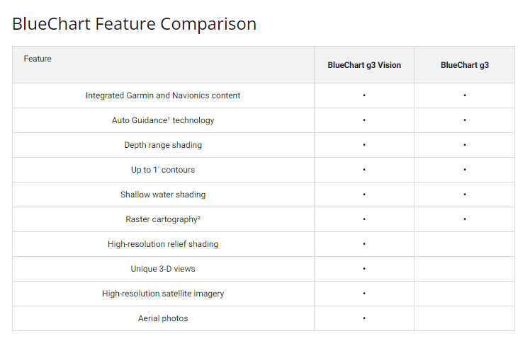
- Auto Guidance Technology for effortless route planning and safe navigation to selected destinations
- Up to 10 depth range shading options for rapid identification of target fishing depths and safe water columns
- Up to 1-foot contour intervals for precise mapping of complex underwater topography and fishing grounds
- Customizable shallow water shading that highlights user-defined depth zones to prevent groundings
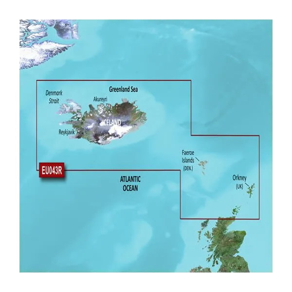
- Comprehensive coverage spanning Iceland, Faeroe Islands, Shetland Islands, and Orkney Islands
- Detailed mapping of major ports and anchorages including Reykjavik, Akureyri, Torshavn, Lerwick, Stromness, and Kirkwall
Data Insights
Garmin's integration of Navionics data with its own cartographic resources produces documented navigation performance gains of up to 30 percent in route efficiency and hazard avoidance. The precise contour mapping and advanced auto guidance system enable mariners to optimize course planning, reduce transit time, and avoid submerged hazards that present significant risk in these high-latitude fishing and cruising grounds.
Usage Instructions
Insert the microSD/SD card into a compatible Garmin chartplotter, fishfinder, or marine GPS unit and follow the device's on-screen menu to activate the chart. Ensure your Garmin device is fully updated to access the latest mapping, routing algorithms, and safety features before departure. The card integrates seamlessly with existing Garmin marine electronics without additional configuration.
Design & Material
This chart card is engineered as a plug-and-play solution for Garmin's marine electronics ecosystem, with a focus on durability and real-time usability in salt-spray and high-humidity marine environments. The high-resolution display ensures clarity during daylight operation and low-light navigation conditions.
- MicroSD/SD card format for compatibility across Garmin's full marine product line
- High-resolution vector-based mapping for sharp detail and fast screen rendering
- Integrated Garmin and Navionics bathymetric data for unmatched coverage accuracy
- Durable construction rated for saltwater marine use and temperature extremes
- User-friendly layer customization and transparency controls to reduce display clutter
- Frequent map updates available for current hazards, port infrastructure, and regulatory changes
Final Verdict
For anyone transiting or fishing between Iceland and Orkney, this chart is essential infrastructure, not optional equipment. The combination of 1-foot contour precision, 10-level depth shading, and integrated hazard data transforms route planning from guesswork to strategy. Order the Garmin Iceland to Orkney BlueChart g3 today and navigate these waters with professional-grade accuracy.


