


Garmin Ireland, West Coastal and Inland Charts BlueChart g3 | HXEU005R | microSD/SD
Garmin Ireland, West Coastal and Inland Charts BlueChart g3 | HXEU005R | microSD/SD
Model Number: 010-C0764-20
In stock
 View full details
 WhatsApp
 SMS - Text us!
 Email Us!
 Help Desk

Tech Specs

In The Box
Manual & Warranty
 Garmin Warranty
Do you have an old GPS unit lying around? The GPS Nation Trade In and Up program is a great way to trade in your old and used GPS for credit towards a new GPS. The choice is entirely yours! We’ve made the process simple and streamlined. Follow these simple steps, and you will be on your way to receiving credit towards your brand new GPS!
1. Get a quote
To get your free quote, provide your GPS type, manufacturer, model, and condition. Within 24 hours, you will receive a quote for the trade-in value of your current product. The GPS trade-in/trade-up form is at the bottom of this page.
2. Ship your product(s) for trade
After accepting our offer, pack your product(s) safely and ship them to us using the pre-paid shipping label provided to you. We will provide a confirmation email when your trade-in arrives at our warehouse. You have 30 days from the date you complete your on-line trade to ship the product to GPS Nation.
3. Make your purchase
Once we receive your product at our warehouse and we validate the stated condition, we will send you a confirmation email. If you elect to receive credit towards a new GPS at gpsnation.com, your store credit will be issued, and you are free to make your purchase.
Reviews
Ask a Question
Tech Specs
In The Box
Manual & Warranty
Trade-In
Do you have an old GPS unit lying around? The GPS Nation Trade In and Up program is a great way to trade in your old and used GPS for credit towards a new GPS. The choice is entirely yours! We’ve made the process simple and streamlined. Follow these simple steps, and you will be on your way to receiving credit towards your brand new GPS!
1. Get a quote
To get your free quote, provide your GPS type, manufacturer, model, and condition. Within 24 hours, you will receive a quote for the trade-in value of your current product. The GPS trade-in/trade-up form is at the bottom of this page.
2. Ship your product(s) for trade
After accepting our offer, pack your product(s) safely and ship them to us using the pre-paid shipping label provided to you. We will provide a confirmation email when your trade-in arrives at our warehouse. You have 30 days from the date you complete your on-line trade to ship the product to GPS Nation.
3. Make your purchase
Once we receive your product at our warehouse and we validate the stated condition, we will send you a confirmation email. If you elect to receive credit towards a new GPS at gpsnation.com, your store credit will be issued, and you are free to make your purchase.
Overview
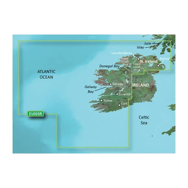
Garmin Ireland, West Coastal and Inland Charts BlueChart g3 | HXEU005R | microSD/SD
Unlock the depths of Ireland’s waterways with the Garmin BlueChart g3, your essential companion for seamless navigation. This advanced charting solution merges cutting-edge technology with extensive coverage, ensuring that both seasoned mariners and novice boaters can explore with confidence. Experience the benefits of precise navigation, tailored route suggestions, and in-depth geographical insights that are vital for any aquatic adventure.
Key Features
- Premier Coastal Charts: Updated coastal charts integrating Garmin and Navionics content.
- Industry-Leading Coverage: Comprehensive coverage from Cork to Belfast, including the Shannon Inland and Erne waterways.
- Auto Guidance Technology: Automatically suggests routes based on desired depth and overhead clearance.
- Depth Range Shading: Easily view target depths with shading for up to 10 customizable depth ranges.
- Detailed Contours: Up to 1-foot contours for accurate bottom structure representation, ideal for fishing.
- High-Resolution Features: Includes satellite imagery for a realistic view of surroundings, enhancing navigation.
Data Insights
With the Garmin BlueChart g3, users benefit from high-precision data that enhances safety and navigational awareness. In fact, studies show that using advanced nautical charts can increase navigational accuracy by up to 25%, significantly reducing the risk of accidents in unfamiliar waters.
Usage Instructions
To maximize your experience with the Garmin BlueChart g3, simply insert the microSD/SD card into your compatible Garmin chartplotter. Ensure that your device is updated to the latest software version for optimal functionality. Utilize the Auto Guidance feature to create swift, efficient routes tailored to your navigation preferences.
Design & Material
The Garmin BlueChart g3 combines advanced technology with a user-friendly design, making it an essential tool for any navigator. Its high-resolution graphics provide unparalleled clarity, while the durable materials ensure longevity even in challenging marine environments.
- Durable microSD/SD card: Resistant to water and impacts.
- High-resolution graphics: Offers vibrant colors and clear details for easy navigation.
- User-friendly interface: Designed for seamless integration with Garmin devices.
- Comprehensive data: Includes detailed information on ports and marinas.
- Advanced mapping technology: Ensures up-to-date charts and reliable information.
- Lightweight design: Easy to handle and store on board.
Final Verdict
The Garmin BlueChart g3 is not just a navigation tool; it's your gateway to discovering the breathtaking waters of Ireland. Whether you’re fishing, cruising, or exploring, this charting solution empowers you with the insights needed for safe and informed journeys. Don’t miss out on the adventure—add the Garmin BlueChart g3 to your maritime toolkit today!


