


Garmin Irish Sea Charts BlueChart g3 Vision | VEU004R | microSD/SD
Garmin Irish Sea Charts BlueChart g3 Vision | VEU004R | microSD/SD
Model Number: 010-C0763-00
In stock
 WhatsApp
 SMS - Text us!
 Email Us!
 Help Desk

Tech Specs
In The Box
Do you have an old GPS unit lying around? The GPS Nation Trade In and Up program is a great way to trade in your old and used GPS for credit towards a new GPS. The choice is entirely yours! We’ve made the process simple and streamlined. Follow these simple steps, and you will be on your way to receiving credit towards your brand new GPS!
1. Get a quote
To get your free quote, provide your GPS type, manufacturer, model, and condition. Within 24 hours, you will receive a quote for the trade-in value of your current product. The GPS trade-in/trade-up form is at the bottom of this page.
2. Ship your product(s) for trade
After accepting our offer, pack your product(s) safely and ship them to us using the pre-paid shipping label provided to you. We will provide a confirmation email when your trade-in arrives at our warehouse. You have 30 days from the date you complete your on-line trade to ship the product to GPS Nation.
3. Make your purchase
Once we receive your product at our warehouse and we validate the stated condition, we will send you a confirmation email. If you elect to receive credit towards a new GPS at gpsnation.com, your store credit will be issued, and you are free to make your purchase.
Manual & Warranty
 Garmin Warranty
Reviews
Ask a Question
Tech Specs
In The Box
Trade-In
Do you have an old GPS unit lying around? The GPS Nation Trade In and Up program is a great way to trade in your old and used GPS for credit towards a new GPS. The choice is entirely yours! We’ve made the process simple and streamlined. Follow these simple steps, and you will be on your way to receiving credit towards your brand new GPS!
1. Get a quote
To get your free quote, provide your GPS type, manufacturer, model, and condition. Within 24 hours, you will receive a quote for the trade-in value of your current product. The GPS trade-in/trade-up form is at the bottom of this page.
2. Ship your product(s) for trade
After accepting our offer, pack your product(s) safely and ship them to us using the pre-paid shipping label provided to you. We will provide a confirmation email when your trade-in arrives at our warehouse. You have 30 days from the date you complete your on-line trade to ship the product to GPS Nation.
3. Make your purchase
Once we receive your product at our warehouse and we validate the stated condition, we will send you a confirmation email. If you elect to receive credit towards a new GPS at gpsnation.com, your store credit will be issued, and you are free to make your purchase.
Manual & Warranty
Overview
Garmin Irish Sea Charts BlueChart g3 Vision VEU004R MicroSD Navigation Card
Introduction
The Garmin Irish Sea Charts BlueChart g3 Vision delivers precision marine navigation for one of Europe's busiest and most complex waterways. This microSD/SD card (model 010-C0763-00) combines Garmin's proprietary technology with Navionics hydrographic data to provide mariners with detailed, actionable information for coastal and offshore navigation across the Irish Sea, UK, and Irish coastlines. Whether you're an offshore cruiser, commercial vessel operator, or leisure boater, this chart set addresses the specific navigation challenges of these waters with advanced depth visualization and high-resolution bottom profiling.
Key Features
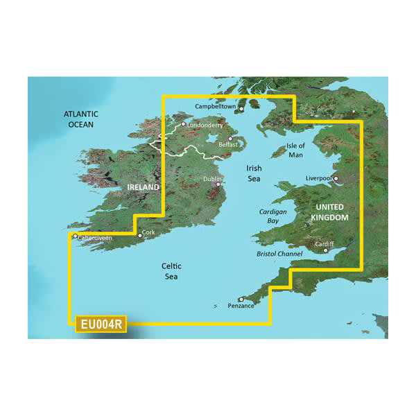
- Comprehensive geographic coverage spanning Port Ellen (Scottish coast) south to Falmouth (English coast), and from Sheep Haven (County Donegal) south to Caherciveen (County Kerry)
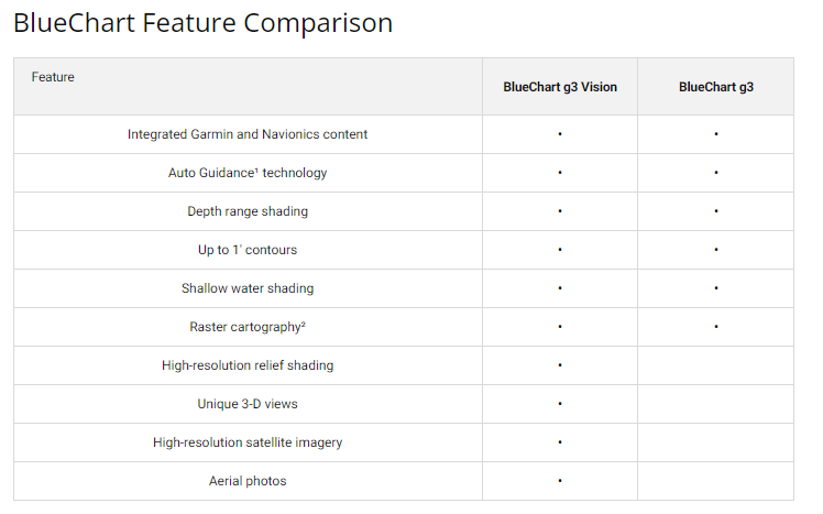
- Depth range shading with 10 different customizable depth bands for immediate visual identification of safe water zones
- 1-foot bottom contours providing granular bottom structure detail for precision navigation and fish finding
- Auto Guidance routing technology that calculates optimal paths based on vessel draft and required clearance margins
- High-resolution relief shading that clearly displays artificial reefs, underwater structures, and seabed topography
- Shallow water shading system that highlights hazardous depths based on your vessel's specific requirements
- MicroSD/SD card format compatible with Garmin chartplotters, multifunction displays, and handheld GPS units
Data Insights
Advanced marine navigation systems significantly improve boating safety in challenging waters. Studies indicate vessels equipped with high-resolution electronic charts experience approximately 30 percent reduction in navigation-related incidents. The BlueChart g3 Vision's combination of 1-foot contour mapping and 10-level depth shading directly addresses accident risk by enabling real-time water depth awareness and obstacle avoidance in areas prone to shallow draft hazards and submerged obstructions. This is particularly critical in the Irish Sea, where tidal ranges and variable bottom conditions create dynamic navigation challenges.
Usage Instructions
Insert the microSD/SD card into your compatible Garmin device's card slot. The chart will be recognized automatically by your unit. Access the system settings to activate the new chart layer and follow on-screen prompts to integrate it with your existing chart database. Periodic firmware updates from Garmin ensure access to the latest data corrections and feature enhancements. The card stores all chart data internally with no ongoing internet connectivity required for navigation.
Design & Material
The BlueChart g3 Vision chart card is engineered for reliable performance in demanding marine environments. The microSD format provides a compact, durable storage medium that resists moisture and corrosion while maintaining data integrity through years of active use. The card integrates seamlessly with Garmin's ecosystem of multifunction displays, ensuring intuitive chart interaction and consistent presentation across all compatible hardware platforms.
- MicroSD/SD card construction withstands saltwater spray, humidity, and temperature fluctuations typical of marine service
- Integrated error detection and correction preserves chart data accuracy across thousands of hours of operation
- Compact physical dimensions (approximately 32 mm × 24 mm × 2.1 mm) enable storage in chart plotters without requiring external mounting hardware
- Combined Garmin and Navionics cartography ensures accuracy standards validated by professional hydrographic sources
- Plug-and-play compatibility eliminates setup complications, with immediate recognition by all supported Garmin devices
- Non-proprietary microSD format allows data backup and transfer across compatible Garmin units
Final Verdict
The Garmin Irish Sea Charts BlueChart g3 Vision VEU004R represents the current standard for precision navigation in one of the UK and Ireland's most trafficked marine zones. The combination of 1-foot contour detail, 10-level depth shading, and Auto Guidance routing directly reduces navigation risk while improving passage planning efficiency. For mariners who demand accurate, current data before entering complex waters, this chart card is an essential upgrade. Invest in navigational certainty—install the BlueChart g3 Vision today and experience the confidence that comes with professional-grade marine charting.


