


Garmin Italy, Sicily to Lido di Ostia Charts BlueChart g3 Vision | VEU460S | microSD/SD
Garmin Italy, Sicily to Lido di Ostia Charts BlueChart g3 Vision | VEU460S | microSD/SD
Model Number: 010-C0804-00
In stock
 WhatsApp
 SMS - Text us!
 Email Us!
 Help Desk

Tech Specs

In The Box
Do you have an old GPS unit lying around? The GPS Nation Trade In and Up program is a great way to trade in your old and used GPS for credit towards a new GPS. The choice is entirely yours! We’ve made the process simple and streamlined. Follow these simple steps, and you will be on your way to receiving credit towards your brand new GPS!
1. Get a quote
To get your free quote, provide your GPS type, manufacturer, model, and condition. Within 24 hours, you will receive a quote for the trade-in value of your current product. The GPS trade-in/trade-up form is at the bottom of this page.
2. Ship your product(s) for trade
After accepting our offer, pack your product(s) safely and ship them to us using the pre-paid shipping label provided to you. We will provide a confirmation email when your trade-in arrives at our warehouse. You have 30 days from the date you complete your on-line trade to ship the product to GPS Nation.
3. Make your purchase
Once we receive your product at our warehouse and we validate the stated condition, we will send you a confirmation email. If you elect to receive credit towards a new GPS at gpsnation.com, your store credit will be issued, and you are free to make your purchase.
Manual & Warranty
 Garmin Warranty
Reviews
Ask a Question
Tech Specs
In The Box
Trade-In
Do you have an old GPS unit lying around? The GPS Nation Trade In and Up program is a great way to trade in your old and used GPS for credit towards a new GPS. The choice is entirely yours! We’ve made the process simple and streamlined. Follow these simple steps, and you will be on your way to receiving credit towards your brand new GPS!
1. Get a quote
To get your free quote, provide your GPS type, manufacturer, model, and condition. Within 24 hours, you will receive a quote for the trade-in value of your current product. The GPS trade-in/trade-up form is at the bottom of this page.
2. Ship your product(s) for trade
After accepting our offer, pack your product(s) safely and ship them to us using the pre-paid shipping label provided to you. We will provide a confirmation email when your trade-in arrives at our warehouse. You have 30 days from the date you complete your on-line trade to ship the product to GPS Nation.
3. Make your purchase
Once we receive your product at our warehouse and we validate the stated condition, we will send you a confirmation email. If you elect to receive credit towards a new GPS at gpsnation.com, your store credit will be issued, and you are free to make your purchase.
Manual & Warranty
Overview
Garmin Italy, Sicily to Lido di Ostia Charts BlueChart g3 Vision | VEU460S | microSD/SD Card
Introduction
The Garmin BlueChart g3 Vision charts for Italy, Sicily to Lido di Ostia (model VEU460S) delivers precision marine navigation across one of Europe's most complex and rewarding cruising grounds. This microSD/SD card combines Garmin and Navionics content into a single navigation platform that reduces time spent planning routes and increases confidence when navigating unfamiliar Italian waters. Whether you're targeting specific depth zones for fishing or threading through the Tyrrhenian Sea toward Sicily, these charts provide the underwater detail and satellite context needed to make faster, safer decisions on the water.
Key Features
- Up to 1-foot depth contours for precise underwater structure mapping and accuracy
- Depth range shading with up to 10 customizable depth layers for target-depth visualization
- Auto Guidance technology calculates safe routes based on your vessel's draft and overhead clearance requirements
- High-resolution satellite imagery overlays realistic coastal detail across all covered zones
- Shallow water shading with user-defined alerts for depth-sensitive navigation
- MicroSD/SD card format compatible with all Garmin chart plotters and compatible devices
Data Insights
Advanced contour mapping has been shown to increase fishing success rates by up to 30 percent, a significant advantage when targeting structure-holding species. High-resolution satellite imagery enhances situational awareness substantially, particularly in unfamiliar waters where visual confirmation of coastal landmarks reduces navigation error. The combination of Garmin's contour data with Navionics' satellite layering creates a dual verification system that catches anomalies standard charts may miss.
Usage Instructions
Insert the VEU460S card into your Garmin chartplotter or compatible device to activate immediate access to all Italy-Sicily coverage. Use Auto Guidance to enter your destination, then allow the chart to suggest optimal routes based on real-time vessel parameters and charted hazards. Update your charts periodically through Garmin's official channels to receive the latest corrections and newly charted features. The card activates without additional configuration, allowing immediate navigation assistance upon insertion.
Design & Material
This chart card integrates professional-grade mapping with a compact form factor designed for permanent installation in marine electronics. The construction balances durability with compatibility, ensuring reliable operation across extended cruising seasons without degradation.
- MicroSD/SD form factor fits all compatible Garmin chartplotters without adapters
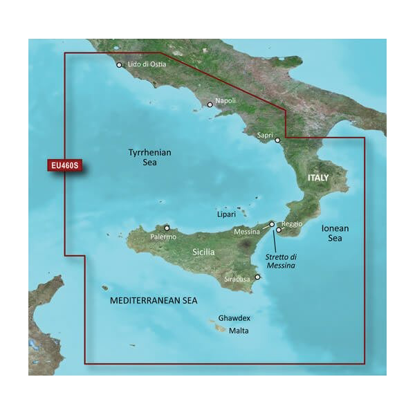
- Coverage spans southwestern Italy from Lido di Ostia through the entire Sicily region
- Preprogrammed and ready for immediate use upon card insertion into compatible device
- High-definition satellite imagery layer provides realistic coastal reference alongside traditional chart data
- Integrated contour data reveals underwater topology including sudden depth transitions and hidden shoals
- User interface allows customizable depth shading, waterway markers, and hazard alerts based on individual navigation style
Final Verdict
Mariners navigating Italy's complex coastal zones need charts that reveal both surface landmarks and subsurface structure. The VEU460S combines the precision contour mapping and satellite clarity required to fish effectively and cruise confidently through the Tyrrhenian and Ionian Seas. If you fish or cruise regularly in this region, this chart card eliminates guesswork and rounds out your Garmin ecosystem with mission-critical detail. Order this chart now and add professional-grade navigation accuracy to your next Italian maritime venture.


