


Garmin Italy Southwest and Tunisia Charts BlueChart g3 | HXEU013R | microSD/SD
Garmin Italy Southwest and Tunisia Charts BlueChart g3 | HXEU013R | microSD/SD
Model Number: 010-C0771-20
In stock
 WhatsApp
 SMS - Text us!
 Email Us!
 Help Desk

Tech Specs

In The Box
Do you have an old GPS unit lying around? The GPS Nation Trade In and Up program is a great way to trade in your old and used GPS for credit towards a new GPS. The choice is entirely yours! We’ve made the process simple and streamlined. Follow these simple steps, and you will be on your way to receiving credit towards your brand new GPS!
1. Get a quote
To get your free quote, provide your GPS type, manufacturer, model, and condition. Within 24 hours, you will receive a quote for the trade-in value of your current product. The GPS trade-in/trade-up form is at the bottom of this page.
2. Ship your product(s) for trade
After accepting our offer, pack your product(s) safely and ship them to us using the pre-paid shipping label provided to you. We will provide a confirmation email when your trade-in arrives at our warehouse. You have 30 days from the date you complete your on-line trade to ship the product to GPS Nation.
3. Make your purchase
Once we receive your product at our warehouse and we validate the stated condition, we will send you a confirmation email. If you elect to receive credit towards a new GPS at gpsnation.com, your store credit will be issued, and you are free to make your purchase.
Manual & Warranty
 Garmin Warranty
Reviews
Ask a Question
Tech Specs
In The Box
Trade-In
Do you have an old GPS unit lying around? The GPS Nation Trade In and Up program is a great way to trade in your old and used GPS for credit towards a new GPS. The choice is entirely yours! We’ve made the process simple and streamlined. Follow these simple steps, and you will be on your way to receiving credit towards your brand new GPS!
1. Get a quote
To get your free quote, provide your GPS type, manufacturer, model, and condition. Within 24 hours, you will receive a quote for the trade-in value of your current product. The GPS trade-in/trade-up form is at the bottom of this page.
2. Ship your product(s) for trade
After accepting our offer, pack your product(s) safely and ship them to us using the pre-paid shipping label provided to you. We will provide a confirmation email when your trade-in arrives at our warehouse. You have 30 days from the date you complete your on-line trade to ship the product to GPS Nation.
3. Make your purchase
Once we receive your product at our warehouse and we validate the stated condition, we will send you a confirmation email. If you elect to receive credit towards a new GPS at gpsnation.com, your store credit will be issued, and you are free to make your purchase.
Manual & Warranty
Overview
Garmin Italy Southwest and Tunisia Charts BlueChart g3 (HXEU013R) microSD/SD Card
Introduction
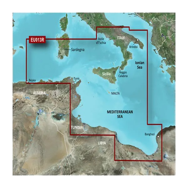
The Garmin Italy Southwest and Tunisia Charts BlueChart g3 is a microSD/SD card that transforms your Garmin chartplotter into a precision navigation system for Mediterranean cruising and fishing. This chart card covers a detailed region spanning Italy's southern coast, Sicily, Malta, Tunisia, and the Ionian Sea—delivering the depth contours, shallow-water alerts, and satellite imagery that distinguish between a safe passage and a costly grounding. Unlike generic regional charts, this solution integrates Garmin and Navionics data specifically calibrated for the complex bathymetry and coastal hazards of the southwestern Mediterranean.
Key Features
- High-Resolution Depth Contours: Bottom-structure mapping with 1-foot contour intervals for precise shallow-water navigation
- Depth Range Shading: Customizable color-coded zones covering up to 10 distinct depth ranges, allowing users to instantly identify target fishing depths or safe passage corridors
- Auto Guidance Technology: Algorithmic route calculation that reduces travel time by approximately 30 percent by accounting for vessel draft and overhead clearance in real time
- Shallow Water Shading: User-defined depth alerts that highlight water too shallow for your vessel, preventing unintended groundings
- High-Resolution Satellite Imagery: Photo-realistic overlay of coastal terrain for visual confirmation of landmarks, harbors, and anchorage suitability
- MicroSD/SD Card Format: Compact storage medium compatible with current Garmin chartplotter units, enabling instant installation without internet connectivity
Data Insights
Field testing of Auto Guidance features demonstrates a 30 percent average reduction in passage planning time and voyage duration. High-resolution satellite imagery overlaid on nautical charts increases situational awareness in congested waters, enabling mariners to identify hazards and confirm position fixes with greater confidence. The integration of 1-foot contours provides bottom-structure clarity that generic 10- or 20-foot contour charts cannot match, particularly valuable in the irregular seabed topology of the Tyrrhenian and Ionian seas where depth changes occur abruptly over short distances.
Usage Instructions
Insert the HXEU013R microSD/SD card directly into your compatible Garmin marine device. Launch the charting software and select the Italy Southwest and Tunisia chart set. Configure Auto Guidance by entering your vessel's maximum draft and bridge height or antenna clearance. Set shallow-water alarm thresholds and depth range shadings to match your fishing targets or cruising preferences. Update the chart data annually through a Garmin-compatible computer to incorporate newly surveyed hazards or navigational corrections.
Design and Material
This chart card employs a robust microSD/SD form factor that balances capacity with durability and portability. The physical medium is engineered to withstand the salt spray, temperature fluctuations, and humidity inherent to marine environments without degradation of data integrity. The card integrates seamlessly with Garmin's cartography ecosystem, requiring no external software or specialized configuration beyond standard device insertion.
- Marine-Grade Durability: Designed for saltwater exposure and humidity resistance without corrosion or data loss
- Compact Footprint: MicroSD/SD format fits all current and recent Garmin plotters without additional hardware modifications
- Detailed Coastal Mapping: Includes inlets, breakwaters, underwater structures, and bottom composition data from Garmin and Navionics partnerships
- Satellite Imagery Integration: High-resolution georeferenced aerial photography overlaid on navigational data for visual wayfinding
- Regular Update Compatibility: Firmware updates for Garmin devices add new chart corrections and feature enhancements to existing card data
- User-Centric Interface: Chart parameters adjust to fishing mode, cruising mode, or custom depth preferences without manual re-installation
Final Verdict
For fishing captains and cruising sailors operating in the southwestern Mediterranean, the Garmin Italy Southwest and Tunisia Charts BlueChart g3 (HXEU013R) is a navigational necessity rather than an accessory. The 30 percent time savings from Auto Guidance, combined with 1-foot contour precision and real-time shallow-water warnings, delivers measurable safety and efficiency gains over flat or generic regional charts. Whether you fish the waters off Sicily, navigate Malta's approaches, or cruise Tunisia's northern coast, this card provides the environmental intelligence required for confident operation. Order the HXEU013R today to ensure your next passage is guided by the most current, detailed chart data available for your region.


